I study tornadoes and the conditions under which they form. Here's how these storm systems develop and what El Niño has to do with it.
The right conditions for a tornado
Two basic conditions are required to produce the rotating supercell thunderstorms that are capable of generating tornadoes:
Warm moist surface conditions and cold air above.
Winds that change in both speed and direction as you move up in the atmosphere, known as vertical wind shear.
Picture a kid who has a helium balloon at a party and releases it - the balloon floats upward. Like that helium balloon, the warm moist air is less dense than the surrounding colder air, so it rises, accelerating upward. This upward motion releases heat, moisture and energy, and causes thunderstorms to develop.
As with many severe weather outbreaks that occur in the U.S., the atmosphere became primed for storms as warm moist air at the surface was being transported northward from the Gulf of Mexico by a series of surface low-pressure systems.
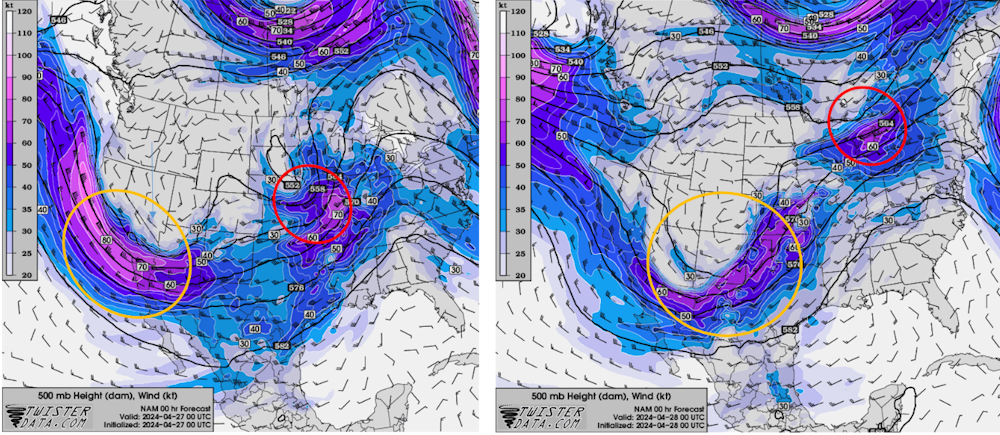
Higher up, about halfway between the ground and where airplanes fly, atmospheric waves within and below the jet stream were transporting cold air through the middle part of the atmosphere. These waves, formally called Rossby waves and commonly referred to as troughs and ridges, also enhanced vertical wind shear.
A small atmospheric wave that moved through the Central Plains and Midwest on Friday, helped trigger the tornadoes in Nebraska and Iowa, including a large, destructive tornado in the suburbs of Omaha, Nebraska, and in the town of Minden, Iowa, about 30 miles away.
The following day, a bigger wave moved through Oklahoma, where tornadoes damaged several small towns that evening.
What was especially important was how close these parameters were to the center of the surface low-pressure system and a warm front that extended just to the east of it. The tornado-producing storms were able to tap into that instability and draw on the strong vertical wind shear generated in the vicinity of the warm front.
The U.S. often sees more frequent tornadoes when the climate is transitioning out of El Niño. The strong El Niño of 2023-24 was decaying in April 2024, and forecasters expect it to be gone by summer .
Weather experts are getting better at predicting tornado conditions. It is not uncommon now to know days in advance of the actual event that an elevated threat exists. Forecasters have high-resolution weather models that can anticipate storms at an appropriate spatial scale to provide a sense of the likely organization of the storms and come close to the location.
The better we understand these storms' attributes, the better those forecasts and warnings can become.
Get updates delivered to you daily. Free and customizable.
Welcome to NewsBreak, an open platform where diverse perspectives converge. Most of our content comes from established publications and journalists, as well as from our extensive network of tens of thousands of creators who contribute to our platform. We empower individuals to share insightful viewpoints through short posts and comments. It’s essential to note our commitment to transparency: our Terms of Use acknowledge that our services may not always be error-free, and our Community Standards emphasize our discretion in enforcing policies. We strive to foster a dynamic environment for free expression and robust discourse through safety guardrails of human and AI moderation. Join us in shaping the news narrative together.


 Most Popular
Comments / 0