undefined
Posts
undefined
Followers
Rain returning to Central Indiana with cooling temps
By Adam Feick,
1 hours agoINDIANAPOLIS (WRTV) – Following a beautiful and an unseasonably warm start to the weekend, we will keep temperatures warm for now as our next system arrives.
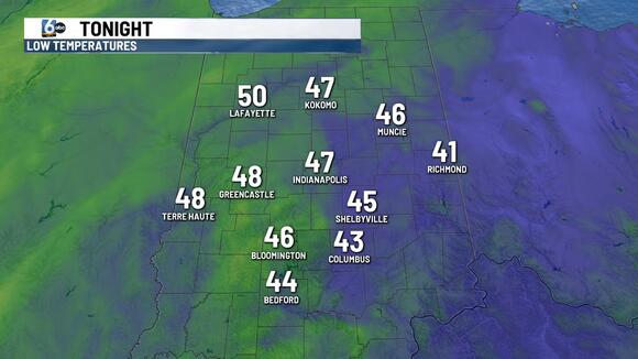
TONIGHT:
Mainly clear skies remain for the night but with mild temperatures earlier in the day, overnight lows will only drop into the 40s. A wide range however with Richmond as low as the low 40s and the western part of the state in the upper 40s.
TOMORROW:
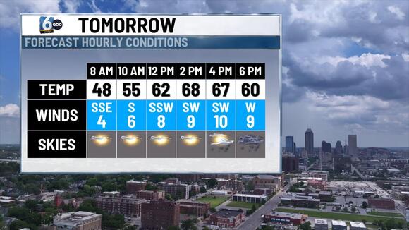
Beautiful start to the day but things will quickly change. Shine will be present for the first half of the day, allowing temperatures to return to the upper 60s and a rogue spot or two in the low 70s. Our next system will work in for the second half of the day. A cold front will move through returning showers for the late afternoon and evening hours. A rumble of thunder or two cannot be ruled out.
7-DAY FORECAST:
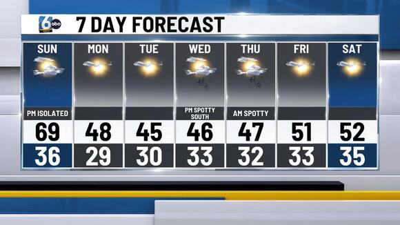
Following Sundays cold front things will calm back down to start the week. Rain showers will exit prior to midnight Monday. Sunshine will return for the day on Monday and Tuesday, however temperatures will be cooler, below normal in the mid to upper 40s. Clouds will return Wednesday as a low pressure system works across the Southern US. A few showers with this system will try to clip southern Indiana, especially spots south of I-70. As the low pressure system exits Thursday a shower or two will be possible in the morning hours. Temperatures will remain slightly below normal in the mid 40s for the rest of the Holiday week. Sunshine returns Friday and Saturday as temperatures will try to return to the 50s.
The post Rain returning to Central Indiana with cooling temps appeared first on WRTV.
 Add to Preferred Sources