undefined
Posts
undefined
Followers
Thunderstorms to sweep through Modesto area. How long will wind and rain last?
By Angela RodriguezSean Macaday,
7 days ago
Register to attend a free virtual forum on Tuesday, Nov. 17 at 6 p.m., on how Central Valley residents can prepare for the coming El Niño season, featuring Sean Macaday, a meteorologist with the Sacramento Bee, and Stanislaus County Deputy Director of Emergency Services Ruben Wegner.
As the Central Valley braces for a potentially record-breaking El Niño season, multiple rounds of rain-producing atmospheric rivers are expected to move through the Modesto region.
The storm systems could bring periods of heavy rain and thunderstorms, along with cooler temperatures and gusty winds.
“A pair of storm systems will bring widespread rain, moderate to heavy rain and snow in the mountains, and gusty to strong southerly winds today into Monday,” the National Weather Service said in a news release Friday.
Here’s what Modesto-area residents can expect:
When will the season’s first atmospheric river hit Modesto?
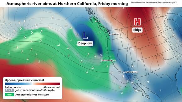
While there was a brief atmospheric river across Southern California and the southwestern U.S. around Halloween, this will be the first to truly soak the entire state, The Sacramento Bee reported.
As cool air from Alaska continues to sink down along the coast, it rapidly saturates the subtropical jet stream with abundant moisture, in part thanks to El Niño.
As the jet stream saturates, it becomes a moving stream of rain stretching thousands of miles across.
In this case, it will stretch along the entire West Coast and out to sea.
Rain was expected to begin in the early morning hours Friday across Southern California and along the Northern California coast as the first few showers ahead of the atmospheric river push through. Those showers were expected to be brief.
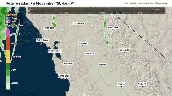
That is expected to change in Northern California after 7 a.m., as a line of heavier showers and even a few thunderstorms push inland along the north Coast Range and the Sacramento Valley.
Heavier and longer-lasting showers should arrive in Sacramento in the late morning and linger through the afternoon.
Further south, showers continue across the Central Valley through the afternoon in Modesto, Merced and Fresno.
Most rain across the San Joaquin Valley will begin to die out between 7 p.m. to 10 p.m. as a lighter sporadic drizzle.
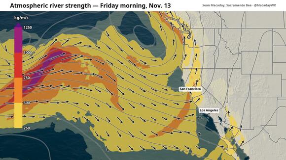
What is an atmospheric river?
According to the National Oceanic and Atmospheric Administration, an atmospheric river is an area in the atmosphere that carries water vapor outside of the tropics.
“The average atmospheric river carries an amount of water vapor roughly equivalent to the average flow of water at the mouth of the Mississippi River,” NOAA said.
When an atmospheric river “makes landfall,” it often releases this water vapor in the form of rain or snow.
“Those that contain the largest amounts of water vapor and the strongest winds can create extreme rainfall and floods,” the weather agency said.
During the atmospheric river event, the National Weather Service said, there is a high risk of heavy precipitation that could lead to flooding and snowfall.
How much rain will fall in Modesto?
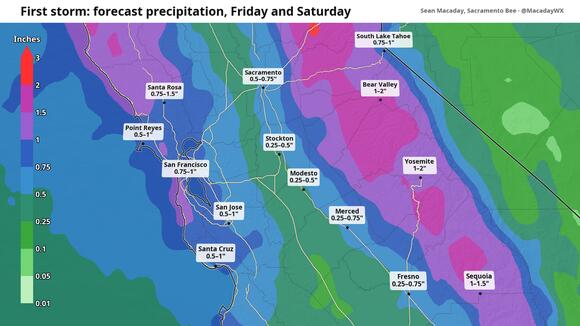
Around half an inch of rain is expected to fall across the Central Valley on Friday and Saturday, with another quarter to half inch possible later Sunday into Monday as the second wave hits.
Approximately 1.09 to 1.11 inches of rain will fall across the Modesto region.
When will second wave of rain hit Modesto?
After a drier Saturday, with partly sunny skies and highs in the 60s across most of the state, rain will return Sunday afternoon and last into Monday.
The atmospheric river arriving on the West Coast on Sunday is expected to be a tad weaker than its Friday counterpart.
A slow-moving line of showers will push through the Sacramento Valley and Northern California on Sunday afternoon with winds gusting up to 20 mph.
The showers will push southeast towards Modesto overnight, and further south into Merced, Fresno and San Luis Obispo by Monday morning.
What’s in the weather forecast for Modesto?
The weather forecast for Modesto shows rain and possible thunderstorms on Friday, according to the National Weather Service.
There is a 90% chance of rain before 5 p.m. and between 9 and 10 p.m.
Daytime highs will reach 66 degrees, while overnight lows will be around 47.
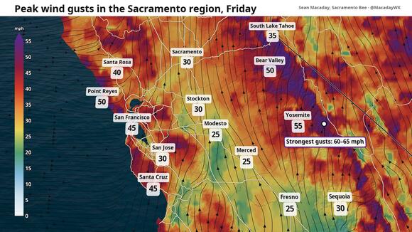
Winds will sweep at around 14 to 16 mph, with gusts reaching as high as 30 mph.
On Saturday, skies will be mostly cloudy, with a high near 66 and a low around 47.
Rain is likely to return on Sunday.
There is a 90% chance of rain in store, with a high near 67 and a low around 49. Winds will sweep at around 6 to 9 mph and gusts reaching as high as 20 mph.
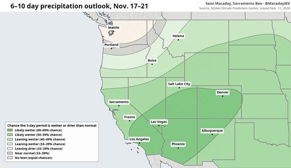
As El Niño continues to provide abundant moisture and unstable air to the south, any atmospheric rivers that develop will be supercharged, with more rainfall and stronger winds to keep storms going longer into next week.
What do you want to know about life in Modesto? Ask our service journalism team your top-of-mind questions in the module below or email servicejournalists@modbee.com.
 Add to Preferred Sources
