undefined
Posts
undefined
Followers
SnowBrains Forecast: Weekend Snow Builds Utah’s Mountain Base
By WeatherBrains,
9 days ago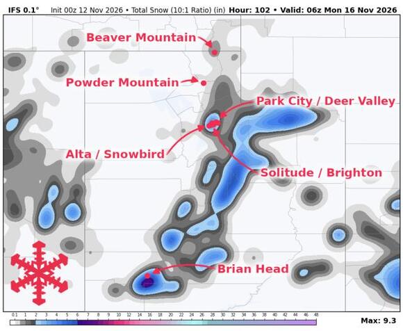
Utah’s snow forecast brings a useful base-building storm Friday into Saturday, followed by opportunities for more snow next week. Brian Head and the upper Cottonwoods have the best accumulation prospects as temperatures cool through the weekend. None of the resorts covered here are open for skiing as of Thursday, November 12, with Brian Head still waiting to confirm opening day.
Most northern mountains stay dry through Friday daytime before precipitation becomes more widespread Friday night and Saturday. Showers can reach Brian Head earlier Friday and develop over the Cottonwoods during the afternoon or evening. Guidance agrees strongly on the storm’s passage, although precipitation amounts vary considerably, particularly around Powder Mountain. Snow levels initially sit near 8,500 to 9,500 feet where showers develop, favoring snow on higher terrain and rain or mixed precipitation near lower bases. Southwest winds also strengthen ahead of the storm, with gusts around 40 mph or higher possible at Brian Head Friday into early Saturday.
Saturday delivers the main accumulation, with denser snow giving way to a somewhat drier finish as colder air arrives. Snow levels fall toward 6,000 to 7,000 feet near the storm’s tail end, while higher mountain temperatures settle into the 20s. Expect 7-10 in at Brian Head and 6-9 in at Alta, Snowbird, and Brighton through Sunday’s lingering showers. Lower elevations receive wetter, denser snow and less accumulation. Compared with Wednesday’s guidance, expected amounts have eased modestly across much of northern Utah, while Brian Head’s outlook has held up. This looks most useful for adding coverage ahead of winter operations.
Sunday brings a substantial lull, although light snow showers may linger over the Cottonwoods. Overnight freezing should help preserve the new snow, but daytime temperatures recover above freezing at many forecast elevations, allowing some settling and surface softening. Another storm is plausible around Tuesday and Wednesday, with a further opportunity later next week. Broad support for a wetter pattern is encouraging, and later storms could bring colder conditions, but differences in timing and storm structure leave their local snowfall potential uncertain. Specific resort totals remain most dependable for this weekend.
Utah Snow Forecast Resort Totals (Fri Nov 13 – Sun Nov 15)
- Brian Head – 7-10 in
- Alta – 6-9 in
- Snowbird – 6-9 in
- Brighton – 6-9 in
- Solitude – 5-7 in
- Park City – 4-6 in
- Powder Mountain – 4-5 in
- Deer Valley – 2-3 in
- Beaver Mountain – 1-2 in
The post SnowBrains Forecast: Weekend Snow Builds Utah’s Mountain Base appeared first on SnowBrains.
 Add to Preferred Sources

