undefined
Posts
undefined
Followers
SnowBrains Forecast: Modest High-Elevation Snow Returns to the Pacific Northwest
By WeatherBrains,
8 days ago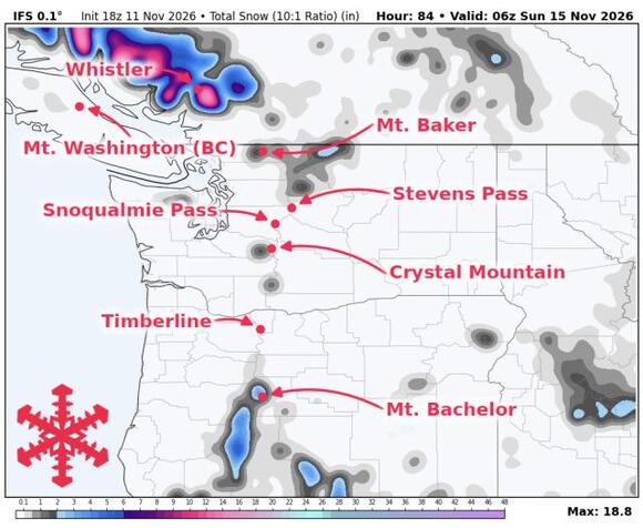
The Pacific Northwest snow forecast favors modest high-elevation accumulation Friday into Saturday, followed by another unsettled stretch Sunday into early next week. Mild air will limit the first round’s usefulness at lower elevations, while colder air behind the weekend systems should help subsequent snow stick farther down the mountains. None of the resorts covered in this forecast are currently open for skiing, making base building the practical focus.
Friday’s front brings the clearest near-term opportunity for accumulating snow across the higher Cascades. Precipitation spreads into Oregon Friday morning and continues farther north through the day, with showers lingering into Saturday before a relative lull. Oregon snow levels generally start around 5,500 to 6,500 feet and briefly fall toward 5,000 to 5,500 feet Saturday. That favors higher terrain at Mt. Bachelor and Timberline, while lower slopes receive rain or mixed precipitation. Expect 3-4 in at Mt. Bachelor’s forecast elevation and 2-3 in at Timberline and Crystal Mountain through Saturday evening. Guidance supports the frontal passage more firmly than the snowfall amounts, especially in Washington. Snow will generally be dense, with temperatures near freezing during accumulation and gusty southerly winds affecting exposed terrain.
Another system approaches Saturday night and Sunday, with colder showers following into Monday. There is broad support for renewed precipitation, but substantial spread in its intensity and how quickly snow levels fall. Whistler has a more promising accumulation signal than the lower Washington locations, although recent guidance has reduced its heavier scenario and agreement remains weak on magnitude. Higher Oregon terrain also has another opportunity to build coverage. The likely evolution is wetter snow initially, followed by somewhat drier snow as colder air arrives, with lower slopes benefiting later than upper elevations. These differences keep Sunday and Monday totals too uncertain for a firm commitment. Timberline’s current operating report confirms it is waiting for sufficient snow, and Whistler Blackcomb’s opening schedule still places the start of skiing after this weekend.
From Tuesday onward, additional mountain snow remains possible, but the signal becomes less organized. Colder conditions would help preserve new snow on higher terrain, while guidance differs considerably on the placement and strength of subsequent precipitation. Oregon retains a more favorable broader precipitation signal than Washington later next week. That supports watching for further base-building opportunities without assuming a sustained regional storm cycle or a major low-elevation turnaround.
Pacific Northwest Snow Forecast Resort Totals (Fri Nov 13 – Sat Nov 14)
- Mt. Bachelor – 3-4 in
- Crystal Mountain – 2-3 in
- Timberline – 2-3 in
- Mount Washington – 0 in
- Mt. Baker – 0 in
- Snoqualmie Pass – 0 in
- Whistler – 0 in
- Stevens Pass – 0 in
The post SnowBrains Forecast: Modest High-Elevation Snow Returns to the Pacific Northwest appeared first on SnowBrains.
 Add to Preferred Sources
