


Early summer heat and humidity will expand across Acadiana over the next week to 10 days, while the chance of afternoon storms slowly decreases into next week.
In the near term, any shower activity will dissipate early Thursday evening with fair to partly cloudy skies and temperatures nearing the lower 70s by Friday morning.

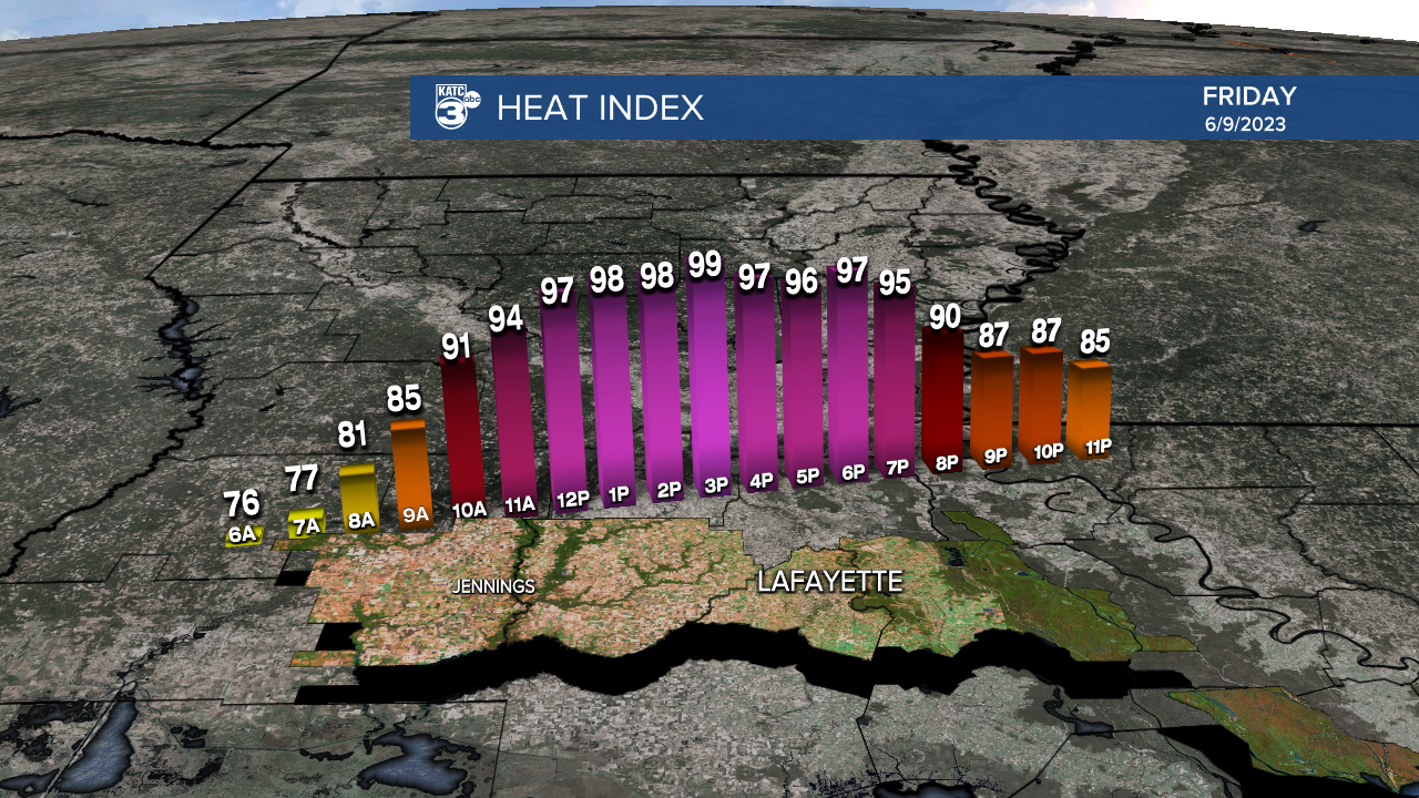
Look for a mostly sunny and hot day to finish our week Friday with highs approaching the mid-90s, while heat indices near the 100° mark.
The chance of an isolated afternoon shower or thunderstorm will remain present Friday, with odds of getting wet closer to 20%.

Look for much the same this weekend with the chance of a few afternoon storms (mainly Saturday) while high temperatures stay planted in the low-mid 90s.
Dew points and morning lows will begin to get more uncomfortable this weekend with readings closer to the mid-70s.
Next week a building ridge of upper high pressure will become the dominant feature in Acadiana's forecast allowing for mostly sunny, hot and humid conditions with the chance of afternoon storms 10% or less for much of the week.
Daytime highs next week will be well into the mid-90s, with heat indices pushing 105°, while night-time/morning lows rise into the extremely uncomfortable upper 70s.
Next week will probably be considered our first little heat wave of the summer.
See the KATC 10 Day Forecast for the latest.
The tropics remain quiet and should stay that way through the next week to 10 days, beyond that, while the GFS model has been touting some tropical development near the Gulf of Mexico by the 3rd week of June...the Euro model gives this scenario no support at this time, and remains too early to even speculate...we'll just keep watching.
El Niño News: Per the Climate Prediction Center, El Niño has officially arrived...and its influence will be on more than just tropical activity.

It's full impacts will be felt later this summer/fall and will likely persist through the winter.
Now while El Niño helps to suppress some hurricane activity and intensities in the Atlantic Basin, we have to be mindful that it should have much less influence on potential early season storm activity through July.

El Niño or not, Gulf of Mexico tropical activity is still a good bet, so be prepared for this and every hurricane season equally, busy forecast or not.

Also of note, this could lead to a rather wet winter for portions of the Gulf Coast as the pattern is conducive to a more active subtropical jet stream, and can pull Pacific moisture and storms, sometimes tapping into atmospheric rivers, towards the Gulf Coast in the winter.
------------------------------------------------------------
Stay in touch with us anytime, anywhere.
To reach the newsroom or report a typo/correction, click HERE.
Sign up for newsletters emailed to your inbox. Select from these options: Breaking News, Evening News Headlines, Latest COVID-19 Headlines, Morning News Headlines, Special Offers
