


So we had two-surge Arctic outbreak West, Plains & Midwest to end January & move into February, a two-surge Arctic outbreak in the Northeast that side-swiped, then briefly teased us. Now, +EPO is doing its thing with surge of warmth, but it will get colder Friday-Saturday. However, that is short-lived. Next round of Arctic air is mid-month, but that looks short-lived.....
Prolonged unseasonable cold (with some snow & ice) is setting up for big chunks of March to the start of April.....
We are behaving like 1990 right now, but will be 1990-1996 combo with time. Both years had rough, wintery March weather. 1990 was late March, 1996 was mid to late March....
Here is the low-down....
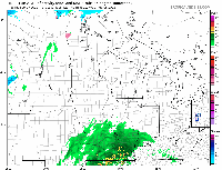
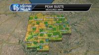
Peak gusts measured from last night are below:

Today, temperatures are falling & low clouds are overspreading the area from the north behind our cold front. Any rainfall amounts last night were only a trace.
Temperatures as of 4:30 p.m. vary from 38 in our northwest to 52 in our southern areas. Even in Greater Lafayette, temperatures vary from 46 on the northwest side of town to 52 on the southeast side of town.
Highs today will go down as 50-55 over the viewing area. Normal for this date is 35-37.
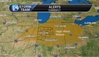
Wednesday night-Thursday storm is tracking a hair more to the northwest & is looking very strong. It will undergo rapid deepening from Illinois to Michigan.
As a result, High Wind Watch is up for the area Thursday morning to 7 p.m. in the evening.

Rain overspreads the area Wednesday night with winds increasing to 25-40 mph (from southeast to south to south-southwest) by early morning.
A couple to few embedded t'storms are possible early Thursday morning as winds continue to increase to 28-45 mph (from the south-southwest).
Some sun may then briefly appear & a narrow, low-topped line of showers & t'storms may pass mid-morning to noon. If we get enough instability (temperatures running 53-60) we may see the MARGINAL RISK of severe weather extended northward into the area.
Regardless, high winds will coincide with & follow this line. Sustained winds 25-40 mph with gusts 45-60 mph (isolated +60 mph) are expected. The highest sustained winds & gusts are expected in the 10 a.m. to 4 p.m. time frame.
Low clouds will pivot in & turn our skies cloudy in the afternoon with temperatures falling to the 30s to near 40 by 5 p.m.
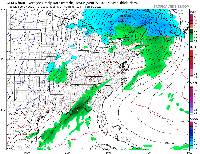
A few rain/snow showers or at least spits of rain/snow showers will pivot in during the late afternoon-evening.
A total of 0.60-1" rainfall is expected.
A few power outages are expected.

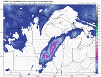
On the backside of the storm, heavy, wind-driven, accumulating snowfall will occur.
Given the wind, local blizzard conditions may occur.

As for Friday, it looks mostly cloudy to cloudy & blustery with highs 33-38 after 29-32 in the morning.
Some rain/snow to snow is possible late Friday-Friday night, but not a certainty. Confidence is low in this forecast as it is unclear where a local band of heavy, wet snow will set up.
Some data has us getting some accumulating snow, others have nothing here.
We know there will be an upper level system that will pivot through parts of the Midwest, Lower Ohio Valley & Southeast, but exact track is unclear.
Lows in the 20s are expected by early Saturday morning.

Saturday is cool with sun & 30s with teens & 20s for lows Sunday morning, but Sunday will turn windy with sun & highs 38-46.
Monday looks windy with skies becoming cloudy. Some showers are possible late in the day with highs 46-52.
After this weak front passes, Tuesday looks cooler with 41-47, but rain is likely Tuesday night Wednesday with 40s to 50 for highs & windy weather. Another 0.60-1" rainfall is possible.

Thursday features another round of rain with even a few t'storms & highs in the 50s (with windy weather).
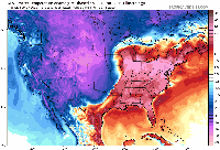
Arctic air then plunges southward, changing rain to snow. We see temperatures drop to well-below normal.

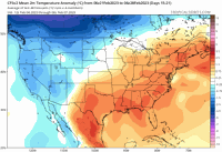
However, watch how quickly we rebound!
The Arctic air comes in with temperatures to +20 degrees below normal......then we are back to temperatures up to 15 degrees above normal by February 22!

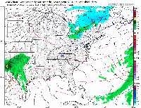
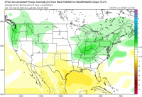
Late February to start of March above normal temperatures & precipitation:


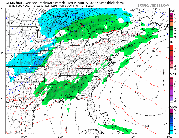
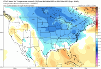
A good chunk of March is quite wintry & colder than normal.
Below normal temperatures dominate mid through late March.
Watch for late-season snow & ice events!

Below normal temperatures could last into early April. Latter half of April looks warmer than normal & quite Summery suddenly.