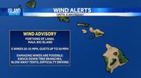
...SMALL CRAFT ADVISORY NOW IN EFFECT UNTIL 6 PM HST THURSDAY...

* WHAT...East winds 20 to 30 kt.

* WHERE...All surrounding coastal waters.

* WHEN...Until 6 PM HST Thursday.

* IMPACTS...Conditions will be hazardous to small craft.

PRECAUTIONARY/PREPAREDNESS ACTIONS...

Inexperienced mariners, especially those operating smaller
vessels, should avoid navigating in these conditions.

&&
Tuesday Evening Weather Forecast: January 31, 2023
Chief Meteorologist Pete Caggiano forecasts for KITV4 Island News during the 5,6 and 10 p.m. newscasts Monday – Friday. He has the American Meteorological Society and National Weather Association Seal of Approval.
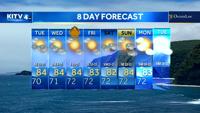
Drier weather through midweek. Trade wind showers increase for Friday into the weekend. Overnight, partly cloudy skies. Lows in the upper 60s. Light winds. Scattered rains focused on Windward Big Island.
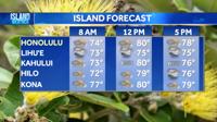
HONOLULU (KITV4) – Drier weather through midweek. Trade wind showers increase for Friday into the weekend.
Overnight, partly cloudy skies. Lows in the upper 60s. Light winds. Scattered rains focused on Windward Big Island.
Wednesday, morning sunshine with comfortable temperatures. In the afternoon sea breezes will allow for a few pop up showers and increased cloud cover. Overall rain chances will be much low.
Highs in the lower 80s. Variable to south winds at 10-15 mph.
Expect a similar pattern for Thursday with increasing trade wind showers for Friday - Weekend.
An out of season south swell will bump south shores near summer time averages. Brown Water Advisories in effect due to the recent heavy rains.
North: 6-8 ft
West: 3-5 ft
South: 5-7 ft
East: 2-4 ft
Do you have a story idea? Email news tips to news@kitv.com
Chief Meteorologist Pete Caggiano forecasts for KITV4 Island News during the 5,6 and 10 p.m. newscasts Monday – Friday. He has the American Meteorological Society and National Weather Association Seal of Approval.