


Local 6 is continuing to track a tricky forecast on Monday evening.
Multiple precipitation types are expected across the area, and one or two degrees in ground temps & temps aloft could make a big difference in what you see in your town.

Travel may become very difficult later tonight and especially tomorrow morning. Bridges, overpasses, sidewalks, and untreated roads may become dangerous.
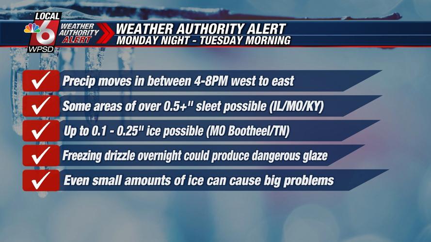
Precipitation will move in between 4 p.m. and 8 p.m. over the area tonight, and most of the short-range models indicate a period of sleet for parts of Illinois, Missouri, and Kentucky (closer to the Ohio River) — possibly accumulating to over a 1/2" or more if it remains all sleet.

Areas farther south toward the Kentucky Tennessee line south into the Missouri Bootheel will see primarily freezing rain, with amount around 0.1-0.25". This should not be enough to create a big concern for power outages, but will create travel problems.

Overnight as the steady precipitation winds down, a period of freezing drizzle is possible before daybreak.
Even though amounts will be very light, temperatures will be in the mid 20s, so a dangerous glaze of ice could develop.
Click here to check Snowman 6 for up-to-date school and government closures in your area.
Click here to download the Local 6 Weather App for weather alerts based on your location.