


While it appears the Chicago area will experience precipitation of some sort this weekend, what exactly we'll see remains up in the air.
If it does snow, accumulation will likely vary widely - depending on where you live.
Here is a timeline of what could occur and when from a weather perspective.
Friday Night
Feeling out of the loop? We'll catch you up on the Chicago news you need to know. Sign up for the weekly Chicago Catch-Up newsletter here.
Snow showers came to an end for the majority of the Chicago area Friday evening following a fast-moving clipper system that dumped snow in some areas, resulting in treacherous conditions and massive pile-ups along the Illinois-Wisconsin border.
While the evening saw temperatures in the mid-30s, colder conditions are expected to set in overnight. Temperatures are poised to drop into the teens as a band of snow moves eastward toward Chicago, according to NBC 5 Storm Team Chief Meteorologist Brant Miller.
Saturday
Local


While you may see some sunshine Saturday morning, don't be deceived.
Accumulating snow is a possibility later on, but rain is as well, depending on which forecast model you look at.

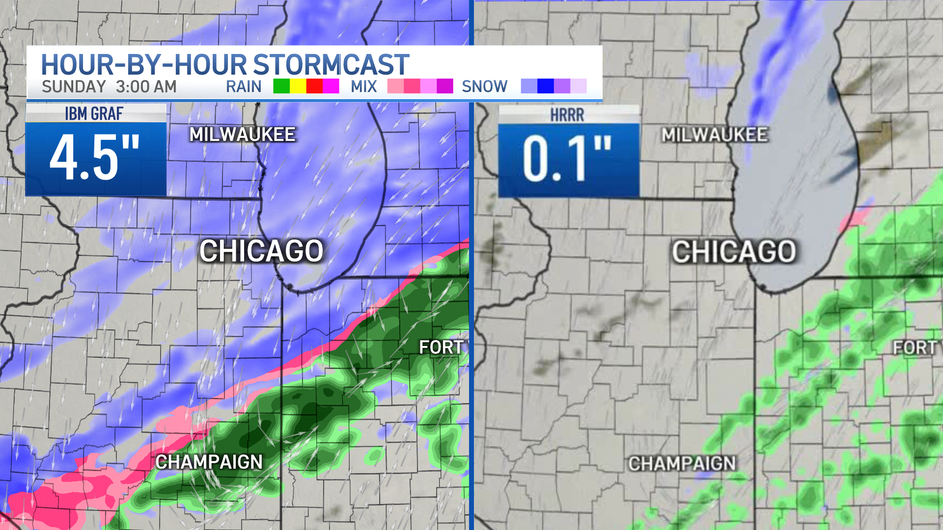
The High Resolution Rapid Refresh model projects the storm system will track further north, meaning it's more liquid, and therefore lead to rain. The other model, the IBM Global High-Resolution Atmospheric Forecasting System, anticipates the center of low pressure will stay further south, meaning more snow.

If the IBM GRAF model holds true, parts of Chicago could see snow begin in the afternoon hours and more than three inches of accumulation through the late evening.
Sunday
If snow does occur, it's poised to continue through early Sunday, with the possibility of snowfall totals in Chicago growing to around 4.5 inches.
However, much more accumulation could be in store for those along the Illinois-Wisconsin state line.
Counties in Illinois along the border could potentially see 6 to 7 inches of snow, while portions of southern Wisconsin could experience up to 9 inches of snow. Snowfall projections are far lower in the western suburbs, with 1 to 4 inches possible.
Some of Chicago's northern suburbs could see around 4 inches of snow, though that likely won't be the case for every community, according to the IBM GRAF model. For the most part, 1 to 2 inches of accumulation are expected across most of Chicago.
Those in southern counties will likely see even less than that, according to forecasts.
If snow does fall during the weekend, it'll likely stick around for a while and bring a chance of flurries come Monday.

