
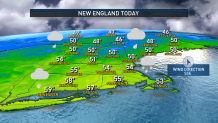
Mild showers falling across all of New England Wednesday are the result of a storm center moving through southern Canada, with its broad, counter-clockwise flow of wind around its center delivering temperatures in the 50s to much of the Northeast Tuesday.
This warmth ensures all precipitation for New England falls as rain, much to the chagrin of ski areas, but a colder pattern starting Friday promises better weather for snowmaking, even if natural snow will continue to be limited in the mountains.
What’s fascinating is the large pattern is actually very similar to the description given by Dr. David Coe in our recent Climate 2022 special on NBC10 Boston and NECN – a large-scale fall weather pattern, but interacting with colder, winter air in spots. One clear example of this is the broad, powerful storm developing over the central Atlantic Ocean, already sporting a wind field with 60 mph sustained wind and being monitored by the National Hurricane Center for potential subtropical storm (partially tropical) development.
Get New England news, weather forecasts and entertainment stories to your inbox. Sign up for NECN newsletters.
This storm will sweep warmth all the way to Greenland as it expands across the North Atlantic, and will send large waves – swell – out in all directions, including building waves offshore of New England’s coast to 12 to 18 feet by the weekend, with eight to 10 foot waves in the nearshore waters. The broad counter-clockwise circulation of air around the huge storm center, combined with a strong high pressure, or fair weather, cell in eastern Canada, will push cool air south into New England, dropping daytime highs of around 50 degrees Thursday to the 40s by Friday under sun with a freshening north wind on Cape Cod gusting to 35 mph.
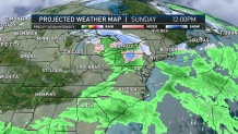
Eventually, moist ocean air will follow the wind as it shifts to blow from the northeast, meaning a gray deck of clouds with showers, drizzle and a raw feeling will overtake much of southern New England for the weekend, with drier but cool conditions in northern New England. Eventually, the air will turn cool enough for some snowflakes to mix in with the raindrops from late Sunday into Monday morning.
Although it remains to be seen just how much snow falls – a few outlier solutions turn pretty snowy in southern New England – right now our team believes the most likely scenario is for a light accumulation, if any, away from the coast Sunday evening and night.
Although next week will start cool, a storm at midweek will open the door to milder air as it deposits rain in southern and central New England, and either rain or snow in the North Country, followed by returning milder-than-normal air at the very end of next week, at the end of our First Alert 10-day forecast.
