According to the November River Report from the Upper Arkansas Watershed Collaborative, most of the Upper Arkansas Basin remains drought-free, but severe and extreme drought have returned to parts of the lower basin.
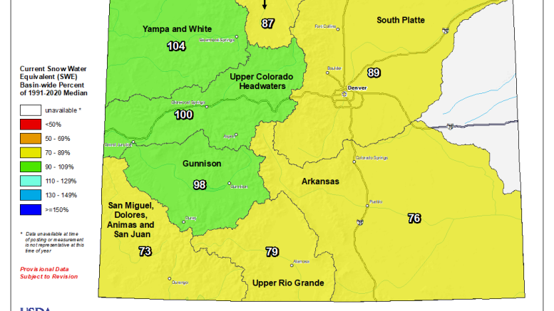
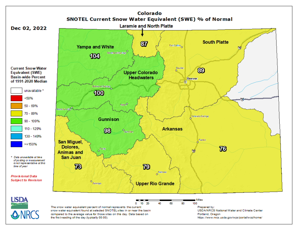
In spite of recent snowfall in the upper basin, early season snowpack is trending below average. SNOTEL data shows basin-wide snowpack at 76% of median. The Saint Elmo SNOTEL station shows the deepest snowpack at 118% of median.
The Governor’s Water Availability Task Force report for November notes that the 2022 Water Year was “the sixth warmest and 35th driest on record going back to 1896.”
Colorado has some of the best “soil moisture in years,” the report says, “but on the eastern side of the Divide, (soil) conditions are a lot drier than normal.
A La Niña weather pattern looks likely to continue through early winter and possibly beyond. On average, the Northern Rockies are wetter and colder during La Niña, which can result in good snowpack conditions in the upper reaches of the Ark Basin.
But La Niña often brings drier conditions to the southern part of the state, including most of the Arkansas Basin.
From Nov. 15 to March 14, the Winter Water Storage Program affects water storage, river flows and calling water rights in the Arkansas Basin.
The Winter Storage Progam stores water during the winter months that would otherwise be diverted by irrigators downstream from Pueblo Reservoir. The stored water is then released during the following irrigation season.
Participants in the Winter Storage Program primarily store their water in Pueblo Reservoir. When space is limited, priority for storage of water in Pueblo Reservoir goes to entities that don’t have access to other storage.
Current water storage at major Ark Basin reservoirs is:
- Pueblo Reservoir – 184,866 acre-feet (57.2% full).
- Turquoise Lake – 84,452.2 acre-feet (65.3% full).
- Twin Lakes – 114,014 acre-feet (80.9% full).
- John Martin Reservoir – 15,921 acre-feet.
Arkansas River flows have generally decreased. The Leadville gauge hasn’t reported any new data for the past week, and the gauge at Granite currently reads 119 cfs.
River flow at Wellsville is 315 cfs, and at Cañon City, 380 cfs. The flow below Pueblo Reservoir has dropped 69.9 cfs, a reflection of the WWSP.
The gauge near Avondale currently reads 289 cfs, while the flow at Rocky Ford has dropped to 68.8 cfs. Flow below John Martin Reservoir has dropped to 1.16 cfs but has increased to 16.3 cfs near Lamar.
With the Winter Storage Program in effect, only eight water rights are currently calling for water in the Arkansas Basin. The most senior calling right is the Lewellyn McCormick right with an 1864 priority date on the Purgatoire River. The 1866 Gonzales Ditch right on the Apishapa River is next in priority, followed by the 1867 Coleman Ditch right on Hardscrabble Creek.
The Fernandez Ditch (1868 priority) has a call on Turkey Creek, the Upper Huerfano No. 2 (1869) has a call on the Huerfano River, and the Doris Ditch (1870) has a call on Fourmile Creek. On the Arkansas River mainstem, the 1910 Fort Lyon Storage Canal right has a call, and as always, the Arkansas River Compact has a call at the Kansas state line to ensure that Colorado sends water to Kansas.
Information provided by the Arkansas River Watershed Collaborative, the nonprofit organization for the Arkansas Basin Roundtable. Formed by the Colorado General Assembly, Ark Basin Roundtable works to find solutions to water-related issues in the basin.

- Conservancy districts oppose major water purchase by Aurora - April 15, 2024
- ARWC releases February River Report - March 10, 2024
- State official to discuss water administration changes today in Salida - March 8, 2024
You must be logged in to post a comment.