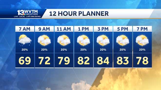
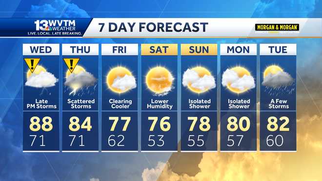
MORNING, ESPECIALLY IN SOME OF OUR NORTHERN COUNTIES WHERE WE’VE GOT SOME STEADY AND HEAVIER RAIN. NUMBERS ARE IN THE FORTIES. THERE IN THE METRO AREA WILL GO WITH SOME LOW FIFTIES AND AREAS OF RAIN REALLY KIND OF OFF AND ON THROUGH THE DAY TODAY. TEMPERATURES A LITTLE BIT LATER ON THIS AFTERNOON THOUGH SHOULD CLIMB INTO THE LOW SIXTIES. HERE’S A LOOK AT OUR RAIN CHANCES. AND THIS MAY BE A LITTLE BIT ON THE CONSERVATIVE SIDE FOR TODAY. THERE’S A LOT OF AREAS THAT ARE GOING TO SEE RAIN, BUT I THINK THERE’LL BE SOME BREAKS. AND I REALLY DO THINK COVERAGE WHAT KIND OF BE A LONG AND NORTH OF I-20 AND THEN REALLY COVERAGE STARTS TO DECREASE TUESDAY ESPECIALLY WEDNESDAY AND THURSDAY. TEMPERATURES ARE REALLY EXPECTED TO WARM IN THE COMING DAYS, TOO. HERE’S LOOK AT OUR FUTURE CASTING. SO YOU’LL NOTICE BY THE MID TO LATE MORNING HOURS, WE MAY GET A LITTLE OF A BREAK BEFORE THE RAIN KIND OF FEELS BACK A BIT. THIS IS AT NOON AND YOU CAN SEE AGAIN SOME OF THE HEAVIER SHOWERS UP A LITTLE BIT CLOSER TO THE TENNESSEE AND THEN THROUGH THE AFTERNOON AND EARLY EVENING. THEY’LL STILL BE SOME AREAS RAIN OR SOME PASSING SHOWERS KIND OF ACROSS AREA WITH NUMBERS EXPECTED TO A LITTLE BIT INTO THE SIXTIES AND I THINK THOSE NUMBERS AT LEAST TEMPERATURES WILL HOLD STEADY THROUGH THE EVENING AND OVERNIGHT PERIOD. AND THEN DAYBREAK TOMORROW CAN SEE AT LEAST A LOT OF CLOUDS AND THE CHANCE FOR A FEW SHOWERS. COVERAGE DOES NOT LOOK TO BE QUITE AS HIGH DURING THE DAY ON TUESDAY. AND THEY’LL STILL BE SOME SHOWERS MOVING ON THROUGH. SO YOU’LL LIKELY NEED TO KEEP UMBRELLA KIND OF HANDY OVER THE NEXT TWO DAYS. ALL RIGHT. HERE’S A LOOK. RAIN TOTALS AND AS I MENTIONED WITH, THE HIGHEST COVERAGE IN THE NORTHERN COUNTIES. THAT’S LIKELY WHERE WE WILL SEE OUR HIGHEST RAIN TOTALS THROUGH THE END OF THE WEEK WITH MAYBE 2 TO 4 INCHES THERE ACROSS NORTH ALABAMA, MORE THAN LIKELY 1 TO 2 INCHES, I THINK ON AVERAGE US HERE ACROSS OUR AREA. IT’S CHILLY, THOUGH, IN NORTH ALABAMA, WHERE GOT THOSE FORTIES FIFTIES. ELSEWHERE THERE’S A LOOK AT OUR THREE MINUTE ADVANTAGE AND A PRETTY GOOD AREA OF REALLY KIND OF MOVING THROUGH COLEMAN AND ARLEY SMITH LAKE OAKMAN DOWN TOWARD BERRY AND MOST OF WHAT WE’RE SEEING RIGHT NOW IN THE BIRMINGHAM METROS PRETTY LIGHT BUT SOME HEAVIER RAIN JUST UPSTREAM. AND SO SOME OF THAT BE MOVING THROUGH. THAT’LL KIND OF MAKE THAT COMMUTE EVEN A LITTLE BIT TOUGHER THIS MORNING. STILL SOME SCATTERED SHOWERS AT TIMES TUESDAY OVERALL WEDNESDAY AND THURSDAY, BUT A BUMPED UP TEMPERATURE IS A LITTLE BIT MORE. LOOK AT THAT, YOU GUYS MID TO UPPER SEVENTIES EXPECTED FOR THE MIDDLE PART OF THE WEEK. BACK TO YOU. OKAY. THANKS, STEPH JUST TURNED 647.
Cloudy and wet to begin the week
![WVTM logo]()
Updated: 7:12 AM CST Dec 5, 2022
A rainy weather pattern develops for the upcoming week. Along with the clouds, mild temperatures will turn warmer by the middle of the week. Check the video forecast for the latest.CLOUDY AND WET WEATHER THIS WEEK Showers will remain possible through the day Monday. Again. the best chance for rain will be areas along and north of I-20. Temperatures will peak in the lower to mid 60s Monday afternoon. SEVEN DAY FORECASTA frontal boundary that moved across the area the state this weekend, will return northward as a warm front Monday, then become stationary in a west to east orientation over or near the Tennessee Valley this week. A series of systems moving along this boundary will bring numerous to widespread showers, along with a few thunderstorms to the area for much of the work week. This may lead to widespread flooding near the Tennessee River.More rain on the way for at least the first half of the week. On average, we see around 1-2" of rain in Central Alabama through next week; those totals increase significantly in North Alabama: up to 5” near the Tennessee border. —STAY WEATHER AWAREGet the free WVTM 13 app and turn on the alerts for the latest weather updates.For the latest Birmingham weather information and central Alabama's certified most accurate forecast, watch WVTM 13 News.Current Weather ConditionsHourly Forecast | 10-Day ForecastInteractive RadarBirmingham SkycamsLive Doppler RadarSign Up For Email Weather AlertsDownload the WVTM 13 AppDon't forget to follow us on Facebook, Twitter and Instagram.
A rainy weather pattern develops for the upcoming week. Along with the clouds, mild temperatures will turn warmer by the middle of the week. Check the video forecast for the latest.
CLOUDY AND WET WEATHER THIS WEEK
Showers will remain possible through the day Monday. Again. the best chance for rain will be areas along and north of I-20. Temperatures will peak in the lower to mid 60s Monday afternoon.
SEVEN DAY FORECAST
A frontal boundary that moved across the area the state this weekend, will return northward as a warm front Monday, then become stationary in a west to east orientation over or near the Tennessee Valley this week. A series of systems moving along this boundary will bring numerous to widespread showers, along with a few thunderstorms to the area for much of the work week. This may lead to widespread flooding near the Tennessee River.
More rain on the way for at least the first half of the week. On average, we see around 1-2" of rain in Central Alabama through next week; those totals increase significantly in North Alabama: up to 5” near the Tennessee border.
—
STAY WEATHER AWARE
Get the free WVTM 13 app and turn on the alerts for the latest weather updates.
For the latest Birmingham weather information and central Alabama's certified most accurate forecast, watch WVTM 13 News.
Don't forget to follow us on Facebook, Twitter and Instagram.


