Second round of storm to arrive Saturday morning; here's what to expect
The second of back-to-back winter storms was making its way Friday toward the Sierra Nevada, where up to 2 feet (61 centimeters) of snow already has fallen on the mountains around Lake Tahoe — much to the delight of area ski resorts.
Mountain highways reopened under sunny skies Friday and classes resumed two hours late at schools around the lake where they were closed on Thursday.
A winter storm warning expired at 4 a.m. Friday but a new one goes into effect at 4 a.m. Saturday into Monday morning for most of the Sierra from south of Yosemite National Park to north of Lake Tahoe and Reno.
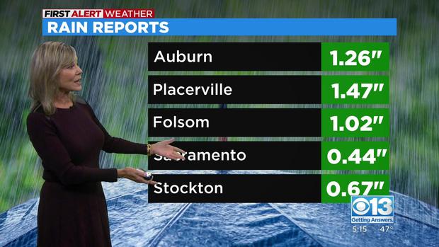
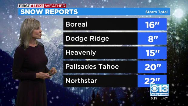
Last 24-hour Totals
Two feet (61 cm) of snow was reported at Homewood resort on Tahoe's west shore, 22 inches (56 cm) at Northstar in Truckee, 20 (51 cm) at Palisades near Tahoe City and 19 (48 cm) at Mount Rose on the southwest edge of Reno.
The most snow so far, 30 inches (76 cm), was recorded late Thursday and overnight south of Yosemite at the top of Mammoth Mountain ski resort near Mammoth Lakes.
Timing The Storm
Saturday
- 6 a.m.-noon: Light rain moves into the valley and will gradually increase through the noon hour -- the region from Redding to the southern portion of the San Joaquin Valley will be affected.
- Snow will persist in the Sierra and there will likely be chain controls in the mountain passes.
- 11 p.m.: Cold air moves in as the earlier system circulates off to the east. Snow levels drop overnight with the colder air.
- The high temperature in the Sierra will be 40 degrees and the low will be 31.
Sunday
- Scattered showers will persist in the valley in the morning. Snow levels will descend to about 5,500 feet.
- The high temperature in the Sierra will be 36 and the low will be 22.
Monday
- Snow will persist in the Sierra. Things will settle down on Tuesday and then we'll dry out Wednesday.
Snow Forecast Totals
- Another 6 to 17 inches (15-42 cm) is expected into the weekend at elevations above 7,000 feet (2,133 meters)
- Four to 10 inches (10-25 cm) is expected to fall below 7,000 around Lake Tahoe, the National Weather Service said Friday.
Local Warming Centers
Cold temperatures have prompted Sacramento and Sacramento County to open warming centers. Between Friday and next Tuesday, you can visit any of these places to stay warm:
- Outreach & Engagement Center (3615 Auburn Blvd.): 8 p.m.-8 a.m.
- North Fifth Street Shelter lobby (700 North Fifth St.): 8 p.m.-8 a.m. Adults only.
- DHA Annex (1725 28th St.): 7 p.m.-7 a.m.
The city of Stockton is also opening an overnight warming zone to help people get out of the cold. Stribley Community Center will be open through Sunday. There, people can get access to food, water, and restrooms. Face coverings are required.
Weather Tools
- Download the CBS13 Weather App and get access to live, interactive radar
- Visit the CBS13 Weather Center for radar images, 7-day totals, the latest video forecast, and more.
- Are you a News Hound? Share your weather footage with us or become a Weather Watcher.
- Visit the CBS13 Weather Facebook page