
Page resident Cindy Stafford gave a presentation on the history of Hite, Utah, at Page Public Library on Nov. 15. The event was part of the Glen Canyon Conservancy’s monthly lecture series.
This item is available in full to subscribers.
To continue reading, you will need to either log in to your subscriber account, or purchase a new subscription.
If you are a current print subscriber, you can set up a free website account and connect your subscription to it by clicking here.
If you are a digital subscriber with an active, online-only subscription then you already have an account here. Just reset your password if you've not yet logged in to your account on this new site.
Otherwise, click here to view your options for subscribing.
Please log in to continue |
Page resident Cindy Stafford gave a presentation on the history of Hite, Utah, at Page Public Library on Nov. 15. The event was part of the Glen Canyon Conservancy’s monthly lecture series.
Many locals know Hite – located at the northernmost extent of Lake Powell – as a place where commercial raft trips take out after floating through Canyonlands National Park, where there used to be a marina. Few knew Hite when there were no bridges, no paved highways and no lake. Stafford’s presentation featured historic photographs and documents from a time when many in the audience had not yet been born.
Stafford visited Page and Hite in 1989 on a pleasure trip. In 2005, she started thinking of working in the Southwest. When she discovered the Page Public Library, she realized that a town that cared enough to build such a great library was a place where she wanted to live. Stafford got a job at Glen Canyon NRA in the interpretation division and volunteered for the cultural resources division.
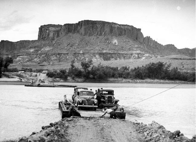
Stafford’s presentation, entitled “Submerged Memories: Dick Sprang Recalls Hite Ferry,” included many historic photographs describing the original settlement and the ferry that transported cars across the Colorado River before there was a lake or a paved road. Hite is 167 miles upstream along the river from Lees Ferry.
As plans were being made for construction of dams on the Colorado River, surveyors documented the topography of the area in the early 1950s. In the interest of efficiency, the survey was limited to a maximum elevation of 3,900 feet, and many canyons simply didn’t show up on the survey drawings. The maximum designed level for Lake Powell is 3,700, so as far as the survey, little mattered for the topography above 3,900 feet.
At the time of the survey, the only way to reach Hite was by driving down a treacherous road in North Wash, also known as Crescent Wash. A sign along the road read, “Danger Flash Flood Area. 60 Wash Crossings Next 18 Miles. Do Not Cross Wash When In Flood.” If the sign didn’t give a traveler pause, the actual wash crossings did, as many of them showed no hint of any sort of road. Maps of the area had the note, “Travel in this area not recommended without a guide.”
Gus Scott floated the river as a young man in 1955. Scott and his friends were anxious to explore the area, as they knew that the dams would come and the chance to explore would be lost. At the time of their trip, the river flowed some 1,500 cubic feet per second. They were the first non-Natives to explore Three Warrior Ruins, which later became known as Defiance House.
Cass Hite (1834-1914) was the first white settler in the area known as Hite. He was a gold prospector and explorer who arrived in southern Utah around 1880. Hite spun tales to the national press about mining for gold in Glen Canyon. These stories helped trigger a rush of miners to the area.
Prospectors soon found that the ore was too small and dusty to extract. The Salt Lake Herald described Hite as a “genial old miner who has found more gold and made less money than any man.” C. Gregory Crampton, a historian at the University of Utah who is best known for documenting cultures and artifacts in Glen Canyon before it was flooded by the Glen Canyon Dam, said of Hite that he was “a strong believer in the rule that it is easier to mine gold out of an investor’s pocket than it is out of the ground.”
Arthur “Arth” Chaffin (1884-1979), an avid hiker and explorer, settled in the area. He knew the area well and was reluctant to share information about it with others, knowing that once the beauty became known, more and more people would arrive. Chaffin coined the term “canyonitis” – “a humorous affliction, but I know of no old riverman who doesn’t seriously carry this disease,” a condition in which one does not disclose too much information about canyon country. The nearest railroad was about 120 miles away, and Chaffin’s nearest Colorado River neighbor was at Lees ferry, almost 170 miles downstream along the river.
The original crossing of the Colorado River was called Dandy Ford, about 5 miles downstream from what would later be the Hite Marina in Glen Canyon National Recreation Area. The ford would allow crossing the river when its flow wasn’t too high.
In 1933, every Utah politician voted for the establishment of Capitol Reef National Monument, and bridges were built across the Colorado and Dirty Devil rivers. The governor of Utah at the time was the first to cross the new bridges, which were still approached by unpaved gravel roads.
There wasn’t enough funding for both the road and the bridges, so the bridges were built first. At the time of the governor’s visit, the bridges were first dedicated as a “marriage” among San Juan, Garfield and Kane counties.
The bridges were described by author John V. Young as standing “a few miles apart in the middle of a vast and silent wilderness, with nothing at either end but a 50-mile stretch of gravel track stretching east and west across a nearly waterless desert.”
The Hite Ferry served from 1946 to 1964 and ceased operations when the paved highway was complete.
Almost 60 years after the completion of Glen Canyon Dam, the area is once again coming out of the watery depths. All that remains of the water-based facilities is a boat ramp, now a slab of concrete in the tamarisk flats. For many in the audience, last week’s lecture was a chance to learn more about an area that they never saw. Scott was in the audience and posed in front of the photo of himself in 1955. He later became a cartoonist for the Batman and Robin comic books.
The schedule for future Glen canyon Conservancy lectures at Page Public Library is available in the Copper Newsletter, a publication by the City of Page. To subscribe free to the newsletter, send a request to copper@pageaz.gov.


