


A warmer day ahead with mostly to partly sunny skies
(WLFI) – Good Wednesday morning! We aren’t as cool this morning. Most areas are seeing lows in the upper 30s to low 40s. A few areas of patchy fog may be possible again across rivers and low-lying areas.
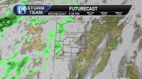
Today's big change in our forecast will be a wind shift from NE to SSW. This will help warm us into the mid to upper 70s in the afternoon with SSW winds 5-10 mph. Increased clouds will also be likely this afternoon and especially overnight.

During the late evening hours into Thursday morning, isolated rain chances may occur but with dry air in place, a lot of the rain may dry up before it hits the ground. Anything on radar will be light in nature.

Thursday
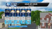
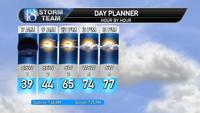
Throughout the early morning hours and into late morning, a few isolated showers/sprinkles may be possible. With increased cloud cover, morning lows will only be in the upper 40s and lower 50s.

During the afternoon and early evening, we are going to get some sun out and warm us up back into the mid to upper 70s.

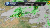
The main cold front will slowly work eastward across the viewing area later Thursday evening. This may cause a weak line of showers and possibly a rumble of thunder. Again, widespread rain is unlikely but this may be our best chance for rain as the cold front passes through. I'm keeping coverage at about 15% to 20%.

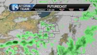
Winds will begin to pick up late out of the North which will give way to a possibility of lake effect rain showers and clouds especially north of Lafayette overnight and into Friday morning.
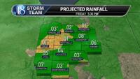
Once said and done with precipitation, I’m thinking only trace amounts to 0.1” of rain will be possible.

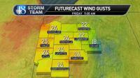
Thursday night and Friday morning will be rather windy at times. North winds will get up to 25-35 mph at times bringing in cooler air for Friday and the upcoming weekend.

Friday
As mentioned above, a few rain showers may be possible north of Lafayette thanks to the strong north wind we will have coming off of Lake Michigan. Clouds will be possible for Friday but then diminish through the evening. Morning lows on Friday will be in the upper 30s and lower 40s then high temperatures will only reach the mid 50s due to strong cold air advection (north winds bringing in cold air).
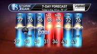
7-Day Outlook
Saturday and Sunday both look dry and sunny with well below normal temperatures. Widespread frost and possibly freeze conditions will be likely both Saturday and Sunday morning. Be sure to bring sensitive plants inside or cover them.
We warm up for next week back into the 70s with our best rain chance possibly working in Wednesday and Thursday as a stronger cold front will work in giving us a chance for storms.


