

Meteorologist Kristy Steward's First Warning Forecast
Ian’s remnants are returning with a vengeance the next couple days. We will see strong winds, rain, major tidal flooding, and a high surf causing ocean overwash and beach erosion through Wednesday. If you are in a flood-prone area, you need to take precautions tonight.
Northerly winds will pick up into Monday. Expect 20-35 MPH sustained winds Monday gusting to 50 MPH. These strong winds will bring us about 2 feet of inundation at high tide 4 AM Monday, rising to 3 feet of inundation at high tide 4 PM Monday. Even at low tide, there will still be minor flooding with about 1.5 feet of inundation on some roadways. The high tide Monday afternoon will be major at 6.9’. This is worse than what we saw Friday by over a foot. For comparison, Hurricane Sandy brought us 6.81’ of tidal flooding in 2012. We have not seen flooding this bad in 10-15 years, especially in the lower Chesapeake Bay.

If you are in a low-lying area, now is the time to move to higher ground, park your car out of the flood zone, and sandbag buildings that are at risk of being flooded. Do not try to drive through these waters, you will ruin your car. Do not let children play in these waters. They are filled with debris, pet waste, hazardous materials, and possibly wild animals.

Waves in the Chesapeake Bay will be 5-9 feet and in the Atlantic 9-15 feet on Monday. Stay out of our Bay and Coastal waters too. Gale and storm warnings are in effect through Monday, likely to be extended into Tuesday, and the rip current risk is high.

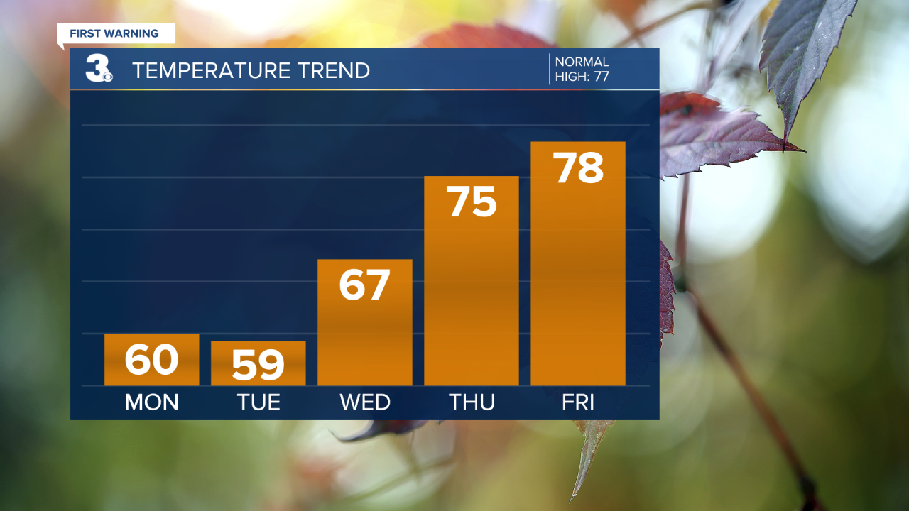
Aside from the high winds creating flooding and ocean overwash/beach erosion Monday, it will also be a wet day. Scattered rain showers persist all day. Temperatures will only rise a couple degrees to around 60° for a high.
Tuesday is going to be another rough day. Still mostly cloudy with scattered showers and strong 15-25 MPH north-northwest winds gusting to 40 MPH. Moderate to locally major tidal flooding is expected at high tide 4 AM Tuesday and 5 PM Tuesday. Tide levels are forecast to be at 6.4’ and 5.9’ during those cycles, respectively. Expect 5-8 feet waves in the Chesapeake Bay and 9-12 feet waves in the Atlantic.
Conditions begin to improve a little Wednesday. We’ll dry out and see some sunshine. Temperatures get warmer into the mid and upper 60s. However, we will still have tidal flooding and a rough surf. Minor to moderate tidal flooding during high tide around 6 AM and 6 PM Wednesday. Both have a forecast high tide level near 5.5’. In the Chesapeake Bay, there will be 3-5 feet waves and 5-9 feet waves in the Atlantic. So, some slight improvements, but still the need to be vigilant with the water.
Tides gradually recede each cycle on Thursday. We’ll still have northerly winds, but they will be lighter about 10-15 MPH. By Friday, our wind direction shifts to southerly and we will certainly catch a break from tidal flooding then.
From Wednesday through the weekend, there will be tons of sunshine to enjoy and dry conditions. Temperatures will gradually rise to the upper 70s by Friday, then a dry cold front cools us down to highs in the mid 60s for the weekend.
Stay safe in the flooding these next few days and remember to turn around, don’t drown when you find a flooded roadway! It’s always worth taking the few extra minutes to find an alternate route than ruining your car or injuring yourself crossing floodwaters.
Connect with Meteorologist Kristy Steward:
FACEBOOK
TWITTER
INSTAGRAM
