Hurricane Ian has made landfall Wednesday on the west coast of Florida as an extremely dangerous Category 4 hurricane, but it will be days before metro Atlanta feels the effects.
The storm made landfall near Cayo Costa with 150-mph winds, threatening deadly storm surge, catastrophic winds and flooding in the Florida Peninsula. It was just shy of a Category 5 hurricane, which would have been only the fifth of its kind to ever make landfall in the U.S.
Only 4 Category 5 hurricanes have made landfall in the US in recorded history:
— Brian Monahan, WSB (@BMonahanWSB) September 28, 2022
Michael (2018), Andrew (1992), Camille (1969), and the 1935 Labor Day hurricane.
Ian is making a run at being the fifth. @wsbtv
“Whether it is a 4 or 5, this is going to have the same impact on southwest Florida, and it’s going to be a catastrophic impact,” Channel 2 Action News meteorologist Brian Monahan said.
1 PM EDT 9/28 Tropical Cyclone Update for Hurricane #Ian.
— National Hurricane Center (@NHC_Atlantic) September 28, 2022
The Earth Networks Station at Naples Grande Beach Resort recently reported a wind gust to 112 mph (180 km/h).
Latest: https://t.co/tnOTyfORCw pic.twitter.com/ERvk04fttd
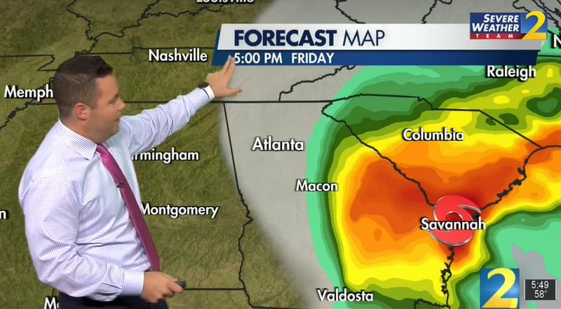
Ian’s current track takes the storm east across Florida on Thursday before turning back to the west off the coast of Georgia. It is expected to make a second landfall Friday somewhere between Georgia and South Carolina as a tropical storm at near-hurricane strength.
According to Monahan, impacts to metro Atlanta are improving based upon current storm track predictions.
[9/28 11AM Tropical Update] Here's the latest #HurricaneIan forecast track. Please remember that impacts will extend beyond the forecast cone. In north and central GA, we are still expecting gusty winds and periods of heavy rainfall from early Thursday through early Sunday. #gawx pic.twitter.com/TONaPCga4r
— NWS Atlanta (@NWSAtlanta) September 28, 2022
Tropical storm and storm surge warnings have been issued for several coastal Georgia counties, with wind gusts up to 60 mph and storm surge up to 7 feet possible as Ian makes its approach.
In preparation, Gov. Brian Kemp has declared a state of emergency for all 159 counties, with up to 500 troops from the Georgia National Guard to be used to help residents prepare for and recover from the storm. The declaration started at 7 a.m. Wednesday and ends at midnight Oct. 28.
At least for Wednesday and Thursday, Atlanta will stay on the dry side of the tropical system, Monahan said.
“All you will notice from Ian today is some high clouds, especially across the Southside,” Monahan said. “North and west of Atlanta, it should be a mostly sunny day and a partly cloudy night tonight.”
The dry air is also contributing to cooler weather. Temperatures were in the 50s in town on Wednesday morning, and some of the higher elevations of the northeast Georgia mountain woke up to numbers in the 30s.
By the way, another pretty sunny day here today (some more high clouds from Ian later in the day).
— Brian Monahan, WSB (@BMonahanWSB) September 28, 2022
Temperatures are chilly! Starting in the upper 30s/40s in the mountains with 50s in metro Atlanta! @wsbtv
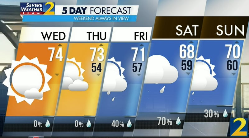
Atlanta is headed for a projected high of 74 degrees, and it will be even cooler Thursday as the city braces for Ian’s rain bands. Monahan expects rain chances to increase beginning Friday afternoon.
“As we go toward Friday night, heavy rain moves into North Georgia,” he said. “West Georgia, not much rain. Metro Atlanta will have downpours around, but the heaviest rain will be on the Eastside — strongest wind gusts, too.”
Wind gusts up to 45 mph are possible, and power outages are likely. East Georgia will see the most impacts from Ian’s remnants, according to the latest forecast, and there is currently no tornado or severe weather risk.
Credit: Channel 2 Action News
Credit: Channel 2 Action News
Monahan expects the rain to begin tapering off Saturday afternoon as the storm moves up the East Coast.
“We are left with just some lingering showers and some breezy, cooler weather Sunday morning,” he said.
Credit: Channel 2 Action News
Credit: Channel 2 Action News
» For a detailed forecast, visit The Atlanta Journal-Constitution weather page.
» For updated traffic information, listen to News 95.5 and AM 750 WSB and follow @ajcwsbtraffic on Twitter.
» Download The Atlanta Journal-Constitution app for weather alerts on-the-go.


