


The Lowcountry is under tropical storm and storm surge watches as Hurricane Ian's projected path has shifted eastward, bringing with it the potential for heavy rain, gusty winds and flooding throughout South Carolina later this week.
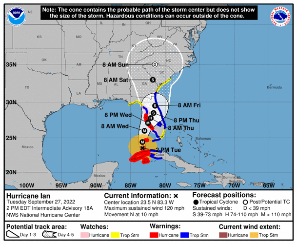
An updated forecast the evening of Sept. 27 marked a "significant shift eastward," according to Ron Morales, a meteorologist at the National Weather Service office in Charleston.
The updated forecast "puts it closer to the water on the Atlantic side, which is more troubling for us," Morales said.
“We are fully prepared for whatever comes...We’ve been through a lot of hurricanes,” Gov. Henry McMaster said Sept. 27. “We know we are going to experience some rough weather.”
The University of South Carolina moved its football game against S.C. State up two days to Sept. 29 in anticipation of the storm. A number of high schools, including in the Charleston area and along the Grand Strand, also moved games up earlier in the week.
The Charleston County School District announced it would shift to remote learning Sept. 30 in preparation for the hurricane, according to its website.
Charleston residents in West Ashley had another way of finding out that extreme weather was headed this way. The Coburg Cow, a local iconic sign at the intersection of Coburg Road and Savannah Highway, was removed from its perch midday Sept. 27 for safekeeping in anticipation of Ian.
Still, the storm's track remains uncertain, Morales noted.

The watch area, which stretches the East Coast from Jacksonville, Fla., to the Santee River north of Charleston, could experience gusts of tropical storm force winds reaching speeds between 39 and 73 mph as early as Sept. 29, Morales said.
Sustained winds at those speeds were less likely, especially more inland, but gusts could still cause power outages and topple trees, he said.
Up to 4 feet of storm surge inundation — which Morales defined as "water above normally dry ground" — could also affect Charleston and other coastal areas Sept. 29 through Oct. 2.
"These are not what I would consider catastrophic, but these are certainly enough to cause issues with flooding roads," he said.
John Quagliariello, a National Weather Service meteorologist in Columbia, anticipated the storm would have impacts throughout the Palmetto State.
He cited the potential for heavy rainfall, flash flooding, landslides and isolated tornadoes, adding officials plan to issue additional watches in the state as Ian moves north.
Local forecasters are expecting 6 to 8 inches of rain in the Charleston area between Sept. 28 and Oct. 1. Tides could reach moderate flood levels of over 7.5 feet on the coast, to major coastal flood levels of over 8 feet on Sept. 29, and remain there through the weekend.
As of 8 p.m. Sept. 27, Ian was 180 miles south-southwest of Punta Gorda, Fla., and roughly 600 miles southwest of Charleston. It is trudging north-northeast at 10 mph.
Ian, a Category 3 hurricane with winds of 120 mph, is expected to gather more strength after battering western Cuba as it makes its way through the Gulf of Mexico toward Florida's western coast.

Forecasters expect the storm will reach Category 4 with wind speeds between 130 and 156 mph before spearing through Florida Sept. 28 — a day earlier than previously forecasted — "as an extremely dangerous major hurricane," according to the National Hurricane Center's latest advisory.
As it moves north on land, Ian is expected to lose steam but Morales warned there is a chance the storm could regain strength again if it continues to shift east over the warm waters of the Atlantic. Both Morales and Joe Coates, Charleston County's emergency management director, called that a "worst-case scenario."
Governor Henry McMaster will hold a media briefing with state emergency management officials today, Tuesday, September 27 at 4:00 PM. The governor will update the public on Hurricane Ian's potential impact on South Carolina. #SCETV #SCEMD
Current projections say by Oct. 1, the storm is expected to settle over Georgia and South Carolina as a tropical storm with wind speeds between 39 and 73 mph.
Because of the track's uncertainty, Coates said the county doesn't plan to announce response plans until after Ian makes landfall in Florida. But preparations are underway, including discussions about opening shelters and staging equipment like high-water vehicles for swift water rescues.
"We're making plans behind the scenes," he said. "We're working through scenarios to keep residents safe."
Coates suggested folks review their emergency plans and restock any expired items in emergency kits. Once the storm arrives, he also encouraged drivers to stay off the roads, but if you must venture out, do not to drive through flooded roads.
For those who live in low-lying areas, he said if you've experienced flooding in the past, expect it again. Prepare to ride out the storm on high ground, he said.
The National Weather Service's Charleston office issued a high rip current risk beginning the morning of Sept. 28. The advisory is extended to all South Carolina beaches.
The county won't close bridges in high winds, but officials discourage motorists from crossing them, especially when speeds reach 40 mph or higher.
Caitlin Ashworth contributed reporting from the Columbia office. Ema Schumer contributed reporting from Charleston.


