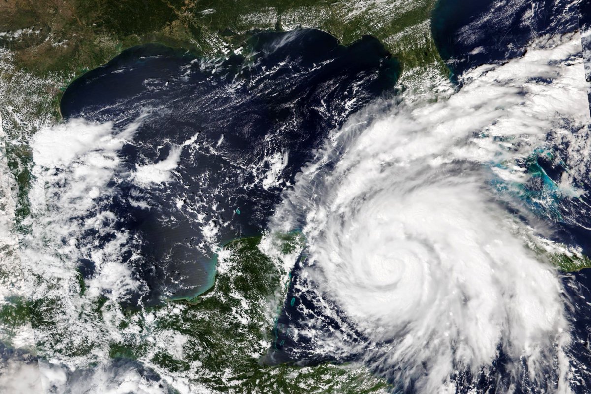
- Hurricane Ian has grown to a Category 3 storm as it made landfall in western Cuba. More than 50,000 people on the island have been evacuated as the storm is clocking maximum sustained winds of 125 mph.
- The storm is now gaining strength in the Gulf of Mexico before its expected to make landfall in Venice, FL Wednesday night.
- Hurricane and Tropical Storm warnings for Ian are in effect for much of the west coast of Florida, where several counties have issued mandatory and voluntary evacuations orders.
- Governor Ron DeSantis warned that the large storm will also have broad impacts in central and eastern Florida. He told residents to anticipate power and communication disruptions.
- Ian is expected to bring heavy rain, life-threatening storm surge and flooding to Florida. Tornado watches have also been issued in southern Florida.
- Tropical Storm warnings are also in effect for Georgia and South Carolina, as heavy wind, rain and storm surge is expected along those coasts later this week.
The live updates for this blog have ended.
State of Emergency Declared in Georgia
Georgia declared a state of emergency ahead of Hurricane Ian's landfall.
Governor Brian Kemp signed an executive order Tuesday issuing a state of emergency in every county in preparation for the storm's impact later this week.
The declaration states that the storm has the potential to produce severe impacts to citizens throughout the southeast coastal region of the U.S., including Georgia.
Today, I issued a State of Emergency in anticipation of the arrival of Hurricane Ian. Please find more information here: https://t.co/FHZEgsI6KT
— Governor Brian P. Kemp (@GovKemp) September 27, 2022
The Georgia Emergency and Homeland Security (GEM/HS) has been directed to provide affected counties with assistance if access to essential public services is disrupted by power outages, debris or flooding.
The state of emergency goes into effect Thursday at 7 a.m. and will end Friday, Oct. 28.
Georgia is currently under a Tropical Storm Watch as the storm approaches Florida. Camden and Glynn counties are under a Tropical Storm Warning, according to GEMA/HS.
Tropical storm conditions are possible along the coast, with a chance of major coastal flooding, dangerous rip currents and beach erosion.
The National Hurricane Center estimates the hurricane is expected to reach Georgia by Thursday.
"Widespread considerable flash and urban flooding" is expected across southern Georgia and coastal South Carolina later this week, the NHC said.
A Storm Surge Watch has been issued for the entire Georgia coast. A Tropical Storm Warning has been issued for Camden and Glynn counties, and a Tropical Storm Watch has been issued for the remainder of the Georgia coast.
— Georgia EM&HS (@GeorgiaEMAHS) September 27, 2022
For preparedness info, visit https://t.co/jybFpTDu5H. pic.twitter.com/Fople1KepL
Starting Friday, Ian will likely impact Southeastern Georgia as a tropical storm or tropical depression with heavy rainfall, Kemp's office said in a statement.
While the storm's path is still uncertain, tropical storm force sustained winds of over 40 mph will be possible across all of Georgia on Friday and Saturday.
Hurricane Ian is expected to bring damaging winds that could down trees and powerlines, two to six inches of rain and flash flooding. Storm surge of three to five feet will also be possible.
On Monday, Kemp activated the State Operations Center to help coordinate local, state and federal response to the hurricane.
GEMA/HS remains at a Level 2 elevated activation and continues to monitor Hurricane Ian's progress and has teams standing by, ready to deploy to impacted areas when needed.
City of Miami Beach Declares State of Emergency
A state of emergency was declared in the City of Miami Beach, Florida Tuesday afternoon, as officials warn of possible flooding in some areas from Hurricane Ian.
"Hurricane Ian is expected to impact the city with tropical storm conditions, including flooding in low-lying areas and strong wind gusts," a City of Miami Beach statement reads.
"While Miami Beach is not expected to experience any direct impacts from Hurricane Ian, I am declaring a state of emergency out of an abundance of caution," said Miami Beach City Manager Alina Hudak. "Our teams are fully operational and proactive in preparing our city, and we have additional support on standby should we need to deploy quickly."
City of Miami Beach Declares State of Emergency
— City of Miami Beach (@MiamiBeachNews) September 27, 2022
— Flooding from Hurricane Ian is possible in some areas —
Learn more: https://t.co/O5oqa7iXuL pic.twitter.com/qYfurw8nf8
January 6th Hearing Postponed
The House January 6 committee scheduled for Wednesday has been postponed due to Hurricane Ian.
"In light of Hurricane Ian bearing down on parts of Florida, we have decided to postpone tomorrow's proceedings," the committee tweeted Tuesday. "We're praying for the safety of all those in the storm's path."
The committee said it would announce the rescheduled date "soon." The last time the Select Committee met was mid-July.
In light of Hurricane Ian bearing down on parts of Florida, we have decided to postpone tomorrow’s proceedings. We’re praying for the safety of all those in the storm’s path.
— January 6th Committee (@January6thCmte) September 27, 2022
The Select Committee will soon announce a date for the postponed proceedings. https://t.co/DgNchy845D
Kentucky, Texas Send First Responders to Florida
Florida is receiving aid from its neighbors ahead of Hurricane Ian's expected arrival.
Kentucky Governor Andy Beshear authorized the Kentucky National Guard to provide direct assistance to Florida.
The state sent three C-130 flight crews to assist in hurricane preparations.
"[The Florida Division of Emergency Management] was there for Eastern Kentucky following July's flooding and we will be there for them during the hurricane," Beshear said in a tweet.
Today I authorized the @KentuckyGuard to provide direct assistance to Florida through three C-130 flight crews. @FLSERT was there for Eastern Kentucky following July’s flooding and we will be there for them during the hurricane.
— Governor Andy Beshear (@GovAndyBeshear) September 27, 2022
Texas Governor Greg Abbott announced he sent first responders to Florida ahead of the storm.
"The spirit of Texas is helping one another in times of need, and we are proud to help our fellow Americans in Florida ahead of the arrival of Hurricane Ian," Abbott said in a statement.
Texas A&M Task Force 1 has deployed a Type 3 urban search and rescue team. The team includes 45 personnel, four boats and two canines.
He also thanked Florida for its help when Texas faced similar Category 3 hurricanes.
"We greatly appreciate the the generosity of Floridians and aid the State of Florida has sent us during times of crisis in our state—and we are honored to do the same," Abbott said.
Texas is sending first responders to Florida ahead of Hurricane Ian.
— Greg Abbott (@GregAbbott_TX) September 27, 2022
The spirit of our state is helping one another in times of need.
Cecilia & I pray for all who are impacted by this storm.https://t.co/y7Mlm37xVo
Images Show Lightning Around Eye of the Storm
Satellite images from the National Oceanic and Atmospheric Administration (NOAA) show lightning flashing around the eye of Hurricane Ian as it churned near Cuba Tuesday.
"GOES East can see its distinct eye as well as lightning flashing around the storm," NOAA Satellites tweeted. "Ian is a major Category 3 hurricane that is continuing to strengthen in the southeastern Gulf of Mexico."
As #HurricaneIan churns near Cuba, #GOESEast can see its distinct eye as well as #lightning flashing around the storm.#Ian is a major Category 3 #hurricane that is continuing to strengthen in the southeastern Gulf of Mexico.
— NOAA Satellites (@NOAASatellites) September 27, 2022
Latest: https://t.co/FYrreOueMf pic.twitter.com/Rh85xqu0Rt
Colorado State University's Cooperative Institute for Research in the Atmosphere also released a video Tuesday showing the eye of the storm.
The impressive and very clear eye of Hurricane Ian this afternoon. pic.twitter.com/vNC3VisXEu
— CIRA (@CIRA_CSU) September 27, 2022
Residents Urged to Prepare to Evacuate With Pets
Florida officials are urging residents under evacuations warnings to include their pets in their preparations.
"Your plans should include all members of your family," Pinellas County Director of Emergency Management Cathie Perkins said. "Including pets."
Hurricane #Ian's deadly storm surge and destructive winds are a threat to your whole family - including your pets!
— Rick Scott (@SenRickScott) September 27, 2022
Prepare NOW before it's too late. https://t.co/tleZ95y0KQ pic.twitter.com/ANC4YRyHZF
The Society for the Prevention of Cruelty to Animals (SPCA) Tampa Bay said pet owners should ensure they have enough food, water and medication for their animals during a storm.
"The most important thing is be ready to move with your pet," SPCA CEO Marth Boden told WFLA. "If you need to evacuate you want to make sure you've got a good, safe carrier. You may not even be in your own vehicle when you're moving around, right?"
Boden said things should be kept familiar for pets to ensure they are calm.
"Try to make sure you're feeding the same food, you've got a toy or two that is familiar," Boden said. "If you can carry something small, if there's a blanket that they always sleep on, bring that with you, put that in the carrier."
She also recommends pet owners stay at the home of a friend or family member or a hotel that has waived pet restrictions.
A a press briefing Tuesday, Florida Governor Ron DeSantis reminded residents that there are pet-friendly shelters across the state.
"Make sure you take care of your pets," he said. "Don't leave your pets behind."
Don’t forget to have a #hurricane plan for your pet.
— Orange County Sheriff's Office (@OrangeCoSheriff) September 27, 2022
Get these items ready NOW:
• Food & Water
• Litter Boxes/Pee Pads
• Medical Records & Medications
If you evacuate, know which hotels or shelters accept fur babies.
Thanks to @ASPCA for these helpful tips.#HurricaneIan pic.twitter.com/fSVYLYcgYp
Heavy Traffic Along Florida Highways
Several major Florida roadways are crowded Tuesday as residents heed evacuation orders ahead of Hurricane Ian's landfall.
Traffic is stacking up on Florida's west coast as people evacuate ahead of Hurricane #Ian. Pack your patience today if you are in Florida. pic.twitter.com/Zl1lQNaI0h
— WeatherNation (@WeatherNation) September 27, 2022
Eastbound lanes on I-4, I-275 and I-75 were packed with heavy traffic as people make their drive inland from the west coast.
Eastbound lands out of Tampa on I-4 are bumper to bumper right now. These people likely trying to get out before #HurricaneIan Here's a pic from @abcactionnews. cc: @Ginger_Zee @robmarciano @GMA @ABC @ABCNewsLive pic.twitter.com/gYUDtZ272k
— Greg Dutra (@DutraWeather) September 27, 2022
Drivers are advised to be patient and safe today as the Florida Department of Transportation (FDOT), the Florida Department of Highway Safety and Motor Vehicles (FLHSMV) and the Florida Highway Patrol (FHP) work to keep traffic flowing.
The Florida Highway Patrol continues to assist with traffic control and evacuation efforts.
— FLHSMV (@FLHSMV) September 27, 2022
We're here for you, Florida. 🫶 https://t.co/dnGVtB3ndR
Highway Patrol officer Tara Crescenzi of the Florida Highway Patrol advised drivers to plan alternate routes inland.
She said troopers are stationed along evacuation routes to "keep people out of harms way."
🚨 If you must travel/evacuate due to #Ian, be mindful of yours and other's safety.
— FLHSMV (@FLHSMV) September 27, 2022
Drive with caution, courtesy and patience. Roads are wet, winds are high, and visibility will be limited. Never drive through floodwater or over/under downed power lines.https://t.co/aJzeZjPiWV pic.twitter.com/yMH9NbGGdD
Highway Patrol tells residents not to drive immediately after the storm through floodwaters or across downed powerlines.
"Drive with caution, courtesy and patience," FLHSMV said in a tweet. "Roads are wet, winds are high, and visibility will be limited. Never drive through floodwater or over/under downed power lines."
Tolls have been suspended, weight restrictions for commercial trucks have been waived and FDOT said it is prepared to open the shoulder to increase traffic flow amid evacuations.
In preparation for Tropical Storm #Ian, I directed @MyFDOT to waive weight restrictions for commercial trucks to ensure ample fuel and resources are coming into FL.
— Ron DeSantis (@GovRonDeSantis) September 25, 2022
We've also waived state requirements to ensure pharmacies can prescribe 30-day emergency refills for medications.
SeaWorld Orlando to Close
SeaWorld Orlando is closing Wednesday and Thursday amid Hurricane Ian's expected landfall, the park announced Tuesday.
"After reviewing the latest route of Hurricane Ian and to ensure the safety of our ambassadors, guests, and animals, SeaWorld Orlando will be closed on Wednesday, September 28 through Thursday, September 29," SeaWorld Orlando wrote in a Facebook post.
"Precautions are in place following the park's comprehensive weather preparedness plan to ensure the safety of our animals and ambassadors during this time."
Residents Wait in Long Lines for Sandbags
Manatee County is now out of sandbags, officials announced Tuesday, citing an "unprecedented demand."
"Due to unprecedented demand and delivering over 200,000+ sandbags, our supplies have been exhausted at all locations," the county posted Tuesday afternoon. "Thank you for your patience. Stay safe!"
Due to unprecedented demand and delivering over 200,000+ sandbags, our supplies have been exhausted at all locations. Thank you for your patience. Stay safe! pic.twitter.com/80RZKtu522
— Manatee County Government (@ManateeGov) September 27, 2022
There have been long lines in Tampa as residents wait for hours to get sandbags. City locations giving out sandbags closed Tuesday afternoon at 2 p.m. ET and warned residents to "expect long lines."
Around noon Tuesday, the city tweeted "all sandbag locations are at capacity. If you are not currently in line, you will not be able to pickup free sandbags."
Nearly 50,000 sandbags were distributed Monday, the city said.
A coworker just snapped this on like for sandbags at Ed Radice Park in #Tampa. #ian pic.twitter.com/CkcTtsfGBm
— Geno from Q105 (@GenoRadio) September 27, 2022
A #Florida resident says he waited three hours to pick up sandbags only to learn that he didn’t make the 2pm cutoff.
— Adi Guajardo (@AdiGTV) September 27, 2022
He says he isn’t sure what to do next to help protect his home. #HurricaneIan #tampa pic.twitter.com/ylecEIrOIB
Biden Calls Mayors, Not DeSantis
President Joe Biden spoke with a handful of Florida mayors Tuesday ahead of Hurricane Ian's expected landfall; however, there are questions about why the President did not speak with Florida Governor Ron DeSantis.
FEMA Administrator Deanne Criswell was asked the question during Tuesday's White House press briefing, she was also present in the Oval Office for the phone calls. She answered that she contacted Governor DeSantis "right away" and said there is a team in place supporting him.
"The President is very focused on making sure that the federal family has the right resources available to them to support this," Criswell continued. "That is why I contacted the Governor [DeSantis] right away and we have a team of my senior leadership that are embedded with the Governor to make sure that we are supporting that."
When again pressed on the question of why Biden did not call DeSantis, Criswell answered "we do not bring politics into our ability to respond to these disasters."
FEMA Administrator Criswell was just pressed on why Joe Biden called Mayors in Florida, but did not contact Governor DeSantis, ahead of Hurricane Ian.
— Tea Party Patriots (@TPPatriots) September 27, 2022
Her response?
“We do not bring politics into our ability to respond to disasters.” pic.twitter.com/W6TE2Uh2yS
Biden spoke with the mayors of Tampa, St. Petersburg and Clearwater, Florida in separate phone calls Tuesday morning.
"The President spoke with the Mayors about the potential impacts of Ian and ongoing efforts Federal, State and local governments are taking to pre-position resources and continue to initiate evacuation operations, including the resources made available through the Federal Emergency Declaration President Biden approved over the weekend," the White House said in a statement Tuesday.
Communication between U.S. Presidents and governors is typical during times of natural disaster and when federal support is requested. Biden did approve Florida's emergency declaration on Saturday, authorizing federal assistance with disaster relief efforts.
National Hurricane Center Says 'Time is Ticking' to Evacuate
The National Hurricane Center (NHC) said Florida residents in the path of the storm are "losing time" to take action before Hurricane Ian makes landfall.
Southwest Florida has today to make final plans ahead of the storm, the NHC said during its 11 a.m. update. The large rain shield ahead of the storm system will contribute to flooding and make it difficult for final preparations.
The storm is currently over the southeastern Gulf of Mexico, according to the NHC 1 p.m. update.
1 PM EDT Sep 27 position update of Hurricane #Ian over the southeastern Gulf of Mexico. https://t.co/cy01fM7Od6 pic.twitter.com/fendQUwrgW
— National Hurricane Center (@NHC_Atlantic) September 27, 2022
Hurricane Ian is expected to make landfall in Florida at around 8 p.m. Wednesday. The storm will then move to southeast Georgia by Thursday and reach the Carolinas by Friday.
There are new tropical storm watches and warnings in Georgia and the Carolinas. Those coasts are also expected to experience four to six foot storm surge.
Parts of northeast Florida also have new warnings. The NHC is expecting storm surge warnings in the Jacksonville/St. John's River area.
9/27 11am ET: Life-threatening storm surge from #Ian is increasingly likely along the Florida west coast where a storm surge warning is in effect, w/ the highest risk from Fort Myers to the Tampa Bay region. Listen to local officials & check https://t.co/0BMJEA5Wz0 for updates! pic.twitter.com/Yvimd5FMzT
— NHC Storm Surge (@NHC_Surge) September 27, 2022
The storm's wind field is getting bigger as it moves into the Gulf of Mexico. The NHC estimates an 80 to 90 percent chance of "dangerous winds" across the impact area.
Even in Tampa Bay, which is north of the expected storm track, should expect significant impacts from the storm. The wind and heavy rain can still knock down trees and powerlines and cause major flooding.
There are large, life-threatening storm surges expected on Florida's west coast. Around 10 feet of surges is expected in the long boat key, Bonita Beach, Charlotte Harbor, Fort Meyers area.
The heavy rain and large storm surge will cause a significant flood risk. The NHC, therefore, urges residents ordered to evacuate should do so.
"Time is ticking," the NHC said. "There is not a lot of time to second guess it."
Here are the 11 AM EDT Sep 27 Key Messages for Hurricane #Ian. Residents in the Hurricane and Storm Surge Warning areas should rush all preparations to completion and follow the advice and evacuation orders of local officials. More: https://t.co/tW4KeGdBFb pic.twitter.com/iT2nCxb4O3
— National Hurricane Center (@NHC_Atlantic) September 27, 2022
DeSantis Says Ignoring Evacuation Orders is a 'Major Risk'
Florida Governor Ron DeSantis urged residents living in areas under evacuation orders to seek shelter inland.
Traffic on I-75 heading inland is moving, DeSantis said. The Florida Department of Transportation (FDOT) is prepared to open the shoulder for emergency use for evacuations if necessary. This would only occur if the traffic reaches below 40 mph, DeSantis added.
FDOT said it will not make roadways one-way during evacuations. This plan has been tested and FDOT said two way traffic is needed to deliver supplies and rescue personnel into the evacuation areas impacted by the storm.
Some traffic on northbound I-75 as we head south toward Venice/Englewood and eventually Lee County. Growing surge impacts in the 11 am track and most of the short term models. #ian #hurricane pic.twitter.com/3smRYXSMyI
— Ginger Zee (@Ginger_Zee) September 27, 2022
DeSantis said fuel will continue to be provided until the state is unable to do so.
Fuel levels currently "look good," he said, despite long lines at gas stations.
Florida residents in the impacted areas should anticipate power outages, the governor said. People who do not evacuate should be prepared to lose power and for it to "not come back on immediately."
DeSantis said there are almost 30,000 people stationed ready to get the power back on once the storm has passed.
He also urged all residents to listen to local evacuation orders.
As #HurricaneIan approaches, locally ordered evacuations are in effect. Check your evacuation zone so you and your family can make informed evacuation decisions.
— Ron DeSantis (@GovRonDeSantis) September 27, 2022
Find your zone at: https://t.co/zT0tDvgR7j pic.twitter.com/g1Q66nIC4z
"Evacuation orders should not be taken lightly," DeSantis said.
There are about 2.5 million people across the state who are currently under some kind of order to seek shelter inland.
People in low-lying, coastal areas should seek shelter on high elevation in solid structures.
Florida has partnered with Expedia to create a webpage for evacuees to find available accommodations in the state.
Gov Ron DeSantis in Sarasota updating public on Hurricane Ian preps and resp. Helpful links include: https://t.co/zRKegFWW1U, https://t.co/6bRIe39nK3 , https://t.co/bFCDNNOoRG… find info there on evacuation zones and orders, shelter help, and updates on school closures @WPTV
— Chris Gilmore (@thechrisgilmore) September 27, 2022
Those remaining without the zones expecting significant storm surge are "taking a major risk," DeSantis said.
"If you evacuate, you're not going to die," he said. "If you are in harms way, you are taking a risk."
DeSantis said the rain, wind and flooding will interrupt power, communications, fuel supply and make it difficult for rescue teams to get in immediately.
"Without power, it gets hot and nasty," he said. "It's not great to be sitting around. That's just par for the course. Make sure you prepare for that."
The governor said it is "better to overprepare" than "wish you'd done more after the fact."
FEMA Says Storm Surge is 'Biggest Concern'
FEMA Administrator Deanne Criswell said storm surge is the "biggest concern" for Floridians as Hurricane Ian barrels towards the state.
Criswell provided an update on Hurricane Ian during Tuesday's White House press briefing. She explained that storm surge is the leading cause of hurricane-related fatalities, referencing five deaths recorded due to storm surge when Hurricane Michael hit the Florida panhandle in 2018.
Storm surge from Ian is expected on the west and east coasts of Florida, including near the Daytona and Jacksonville areas. Criswell said "significant rainfall" is also expected, with isolated parts of Florida receiving a possible 25 inches of rain.
As of Tuesday morning, the National Hurricane Center upgraded Hurricane Ian to a Category 3 storm, with winds around 125 mph. Criswell said Ian is moving towards Florida at about 12 mph, with landfall expected somewhere between Fort Meyers and Tampa.
When the storm does reach the Florida shore, it will slow down to about 5 mph, Criswell said. She called the slowdown "significant" because it means Floridains will experience impacts from the storm for a "very long time."
.@FEMA_Deanne Criswell message for everyone in Florida: "This is going to impact everyone in different ways so you need to stay focused...get ready and do not underestimate the potential that this storm can bring. Know where you are going to get your information..." #HurricaneIan pic.twitter.com/vW9QJ5zPlR
— CSPAN (@cspan) September 27, 2022
Storm to Make Landfall in Venice Wednesday
Florida officials believe Hurricane Ian will make landfall in the Sarasota area of Florida Wednesday night.
During a press briefing with Governor Ron DeSantis, Florida Director of Emergency Management Director Kevin Guthrie said the National Hurricane Center is predicting Ian will hit Venice, FL at about 8:20 p.m. Wednesday.
Sarasota County also announced that the evacuation orders have been extended to include both levels A and B and for anyone in the county living in a mobile home, RV or houseboat.
As the storm shifts eastward, authorities still expect high winds and storm surge north into the Tampa Bay area. DeSantis said the entire west coast of Florida should prepare for storm impacts.
The storm track has shifted south of Tampa Bay, according to the National Hurricane Center. But DeSantis said there is still time for the storm path "to wobble" and change direction as it passes over the state.
DeSantis said the storm is expected to slow down "to almost a crawl" after it makes landfall. He said this will dump and inordinate amount of rainfall inland.
Hurricane Ian is a "big storm" that will "kick up water" and lead to significant flooding and life-threatening storm surge, he added.
The Sarasota County city of Venice is expected to be landfall for Hurricane Ian, Florida Emergency Management Director Kevin Guthrie said Tuesday.https://t.co/f0d7bNqTdH pic.twitter.com/xfRja8QQXn
— Sarasota Herald-Tribune (@HeraldTribune) September 27, 2022
What Ian Looks Like From Space
NASA released satellite images showing what Hurricane Ian looks like from space.
The footage captured from the The International Space Station shows the massive storm about "260 miles below the space station as the storm was gaining strength south of Cuba and moving toward Florida" on Monday afternoon.
#HurricaneIan is seen about 260 miles below the space station as the storm was gaining strength south of Cuba and moving toward Florida at around 3pm ET on Monday, Sept 26, 2022. pic.twitter.com/GNef1ptraA
— International Space Station (@Space_Station) September 26, 2022
American Airlines Issues Travel Alert for 20 Airports
American Airlines issued a travel alert for 20 airports in the western Caribbean and Florida due to Hurricane Ian.
The alert allows customers impacted by the storm to rebook without change fees. The alert applies to the following airports:
- Daytona Beach, Florida (DAB)
- Destin / Fort Walton Beach, Florida (VPS)
- Fort Lauderdale, Florida (FLL)
- Fort Myers, Florida (RSW)
- Gainesville, Florida (GNV)
- Grand Cayman, Cayman Islands (GCM)
- Havana, Cuba (HAV)
- Jacksonville, Florida (JAX)
- Key West, Florida (EYW)
- Kingston, Jamaica (KIN)
- Melbourne, Florida (MLB)
- Miami, Florida (MIA)
- Montego Bay, Jamaica (MBJ)
- Orlando, Florida (MCO)
- Panama City, Florida (ECP)
- Pensacola, Florida (PNS)
- Sarasota / Bradenton, Florida (SRQ)
- Tallahassee, Florida (TLH)
- Tampa, Florida (TPA)
- West Palm Beach, Florida (PBI)
"In order to assist customers who have chosen to evacuate via air, American added reduced, last-minute fares for cities that will be impacted by Hurricane Ian," an American Airlines statement reads. "Additionally, American is waiving checked bag fees for up to two checked bags to/from certain affected airports and waiving fees for carry-on pets to/from all affected airports."
As of noon Tuesday, 100 flights into Tampa International Airport had already been canceled. The airport announced it will suspend all operations at 5 p.m. ET Tuesday.
Tampa International Closing Later Today
Tampa International Airport will suspend all operations early Tuesday evening in anticipation of Hurricane Ian.
The airport will close at 5 p.m. ET, airport officials announced.
"The 5 p.m. closure will allow the Airport to prepare the airfield and terminals, including the securing of jet bridges, ground equipment, and any remaining aircraft," a Tampa International Airport statement reads. "The Airport, including the Main Terminal, Airsides, and parking garages will be closed to all visitors at that time."
The focus will shift on reopening the airport as the storm passes, Tampa International Airport CEO Joe Lopano said during a Tuesday morning press conference. At this time, there is no set date for reopening. He added that airlines are already canceling flights and urged travelers to check their flight status.
Hurricane Ian continues to intensify as it churns toward Florida. The Tampa Bay area is expected to be hit with strong wind, heavy rain and storm surge.
ICYMI: TPA leaders provided an update regarding Hurricane Ian’s impacts on Airport operations and planned recovery. The Airport will be suspending operations at 5 p.m. today.
— Tampa International Airport ✈️ (@FlyTPA) September 27, 2022
Watch it here: https://t.co/WtZ5YbWka5
Florida Keys Under Tornado Watch
The Florida Keys are under a tornado watch Tuesday ahead of Hurricane Ian's landfall.
"Tornadoes are possible in vicinity of the Florida Keys and across the southern into central Florida Peninsula through tonight in association with Hurricane Ian," the National Weather Service Storm Prediction Center said in a Tuesday morning update.
A tornado watch means a tornado is possible in the area. A tornado warning is issued when a tornado is happening or about to happen.
All the Florida Key are now under a 𝐓𝐎𝐑𝐍𝐀𝐃𝐎 𝐖𝐀𝐓𝐂𝐇. Tornadoes can be extremely dangerous. Safe places include an interior room without windows. If you receive a tornado warning, take shelter immediately! https://t.co/rWuZtF7IjV. #FLKeys #KeyWest #FLwx pic.twitter.com/lGksPAi6vJ
— NWS Key West (@NWSKeyWest) September 27, 2022
A tornado watch was also issued for several southern Florida counties, including Broward, Collier, Henry, Miami-Dade, Monroe and Palm Beach, until 5 p.m. EDT Tuesday.
This includes southern Florida cities like Naples, West Palm Beach, Miami and Fort Lauderdale, according to Florida Storms.
The Storm Prediction Center said the magnitude of the tornado threat across the state will depend on Hurricane Ian's track and forward speed, "which remain uncertain at this time."
By Wednesday, however, the center said some reduction in the tornado threat is possible, as Ian is expected to weaken after making landfall.
Tornado Watch for Broward, FL; Collier, FL; Hendry, FL; Miami-Dade, FL; Monroe, FL; Palm Beach, FL from Tue Sep 27 8:58 AM until Tue Sep 27 5:00 PM. #FLwx pic.twitter.com/x5cEStyl8O
— Florida Storms (@FloridaStorms) September 27, 2022
Western Florida Counties Issue Evacuation Orders
Several counties on the west coast of Florida have issued evacuation orders as Hurricane Ian continues to intensify as it approaches the state.
The Florida Division of Emergency Management has compiled evacuation orders for each county. Residents are also encouraged to monitor their local authorities for evacuation updates.
🚨 Tues 9/27/22, 10AM: Mandatory evacuations are in effect for vulnerable areas of Charlotte, Hillsborough, Lee, Levy, Manatee, Pasco, Pinellas & Sarasota counties.
— FL Division of Emergency Management (@FLSERT) September 27, 2022
🌀 Residents in these areas should follow all orders from local officials & leave as quickly & safely as possible. pic.twitter.com/EtCympQDuS
Charlotte County
Mandatory evacuation order is in effect for Zone A. This includes those living on the barrier islands of Don Pedro Island, Knight Island (Palm Island), Little Gasparilla Island, Gasparilla Island, and Manasota Key, as well as residents in any zone living in mobile homes and trailers.
Charlotte County shelters in Port Charlotte are now open! Charlotte County Emergency Management has ordered an evacuation for Zone A - Red areas. This includes those living on the barrier islands as well as residents in any zone living in mobile homes and trailers. pic.twitter.com/TNKW8cU7mq
— Charlotte County Emergency Management (@CCOEM) September 27, 2022
Collier County
Voluntary evacuation orders are in effect for Zone A.
Hernando County
Voluntary evacuation orders have been issued for all areas west of US 19, which includes Zones A, B and C.
All residents living in coastal and low-lying areas, as well as manufactured homes county-wide, are included.
Residents are advised to seek safe shelter with family or friends that reside in a safe structure. If this is not a possibility, a public shelter will open at 9 a.m.
HERNANDO COUNTY: Mandatory evacuations have been issued for all areas west of US 19 in Hernando County including evacuation zones A, B, & C. Residents in coastal & low-lying areas, as well as manufactured homes, are included. https://t.co/OjXJleeaZf pic.twitter.com/bHOYvOo0xv
— Spectrum Bay News 9 (@BN9) September 27, 2022
Hillsborough County
Mandatory evacuation orders are in effect for both Zones A and B.
Those living in mobile and manufactured homes are encouraged to evacuate as well.
JUST IN: The voluntary evacuation order for Zone B in Hillsborough County will become mandatory at noon today@HillsboroughFL #HurricaneIan pic.twitter.com/NWXiAPdjny
— Jennifer Delacruz (@JenDelacruzTV) September 27, 2022
Lee County
Mandatory evacuation orders are in effect for Zones A and B.
These areas include all low-lying areas along coastal areas and barrier islands, as well as residents south of Veterans Parkway in Cape Coral and residents who live in mobile and manufactured homes.
#BREAKING: Zones A and B in Lee County are under a MANDATORY evacuation. This includes a good portion of Cape Coral, North Fort Myers, Fort Myers Beach, Sanibel, Captiva, Bonita Springs and the Iona Mcgregor area. #HurricaneIan pic.twitter.com/1ZKHU3fHY1
— Kaitlin Knapp (@Kaitlin_Knapp1) September 27, 2022
Levy County
Mandatory evacuation orders are in effect for coastal communities, RV parks, mobile homes and low-lying areas.
Manatee County
Mandatory evacuation orders are in effect for Zones A and B. There is a voluntary evacuation order for Zone C.
UPDATE: There is now a MANDATORY Evacuation currently in effect for Zones A and B, and VOLUNTARY Evacuation for Zone C in Manatee County. See thread below for details. https://t.co/yaCwvSk2vz
— Manatee Sheriff (@ManateeSheriff) September 27, 2022
Pasco County
Mandatory evacuation orders have been issued for Zone A, for those living in manufactured homes, mobile homes or RVs anywhere in the county, those living in a low-lying area or an area prone to flooding, those living in a structure that historically has experienced flooding during heavy rainfall and those living in an area ordered evacuated by local authorities due to life-safety hazards.
Voluntary evacuation orders have been issued for Zones B and C.
#PascoCounty is issuing mandatory and voluntary evacuations for Zones A, B & C. This includes coastal and low-lying areas prone to flooding. Anyone living in a mobile home or who has special needs is also encouraged to evacuate. Details: https://t.co/Qv63xoFt5M pic.twitter.com/8HAL9ovziB
— Pasco County Emergency Management (@Pasco_FL_OEM) September 26, 2022
Pinellas County
All residents in Zones A, B and C, including those living in mobile homes, are under a mandatory evacuation order as of Tuesday morning.
As of Tuesday morning, Sept. 27, @PinellasCoNews has issued a #mandatory #evacuation for residents in Levels A, B, C & mobile homes for #HurricaneIan. Life-threatening #stormsurge, #flooding & dangerous #winds are expected in these areas. pic.twitter.com/ZvQv2Chemb
— City of Clearwater, FL (@MyClearwater) September 27, 2022
Taylor County
Voluntary evacuation orders have been issued to residents in the county.
Sarasota County
There is a mandatory evacuation order for Level A starting Tuesday. This includes the barrier islands, mobile homes and those living on vessels.
We have called for the evacuation of Level A in Sarasota County starting Tuesday. If you need to utilize an evacuation center, Sarasota County emergency evacuation centers open at noon Tuesday. Learn more at https://t.co/vcr9BPErgV or call 311.
— SarasotaCountyGov (@SRQCountyGov) September 26, 2022
Thousands Evacuated in Cuba as Ian Makes Landfall
Hurricane Ian made landfall in western Cuba Tuesday as a Category 3 storm.
The storm hit the Pinar del Rio province at 4:30 a.m. EDT. Officials in the region set up 55 shelters and have evacuated 50,000 people, according to the Associated Press.
4:30 AM EDT 9/29 Update: Ian continues to strengthen and makes landfall over western Cuba with maximum sustained winds of 125 mph. pic.twitter.com/j2GV64TcuG
— National Hurricane Center (@NHC_Atlantic) September 27, 2022
Local authorities also brought in emergency personnel and took action to protect tobacco crops.
With maximum sustained winds of 125 mph, the National Hurricane Center (NHC) said Ian is "battering western Cuba with high winds and life-threatening storm surge."
El municipio de San Luis tras el paso del #HuracánIan. #PinardelRío
— TelePinar (@TelePinar) September 27, 2022
📸 Lázaro Manuel Alonso pic.twitter.com/i9smqH2fs4
The Cuban provinces of Isla de Juventud, Pinar del Rio and Artemisa are under a Hurricane Warning while the provinces of La Habana, Mayabeque and Matanzas are under a Tropical Storm Warning.
Tras la calma del ojo del #HuracánIan… en la ciudad de #PinardelRío vuelven las lluvias y vientos fuertes. pic.twitter.com/yDiCcMUVo5
— TelePinar (@TelePinar) September 27, 2022
Western Cuba has been hit with six to 12 inches of rain, with some areas receiving up to 16 inches. These rains may produce flash flooding and mudslides in areas of higher terrain in the region, the NHC said.
"Strengthening is expected later this morning after Ian emerges over the southeastern Gulf of Mexico," the NHC said in a Tuesday morning storm update. "Ian is forecast to approach the west coast of Florida as a dangerous major hurricane."
Here are the 5 AM EDT Key Messages for Major Hurricane #Ian. More: https://t.co/tW4KeFW0gB pic.twitter.com/0uzMONna9h
— National Hurricane Center (@NHC_Atlantic) September 27, 2022
Disney World Among Theme Parks Monitoring Storm
Theme parks in central Florida are keeping a watch on weather forecasts as Hurricane Ian is expected to make landfall this week.
Disney said its Walt Disney World Resort is operating under normal conditions but is "closely monitoring" the storm.
"Walt Disney World Resort is operating under normal conditions. We are closely monitoring the path of the projected weather as we continue to prioritize the safety of our Guests and Cast Members," the company said in its latest statement Saturday.
Universal Orlando Resort is also "closely monitoring" Hurricane Ian. The resort currently remains open.
Hi there, our resorts monitor the conditions closely and would take any and all safety measures required for our guests weathering the storm with us. Please feel free to contact our Online Ticket Store at 407-224-7840 with any questions regarding your tickets. Thank you https://t.co/exi368FzID
— Universal Orlando Resort (@UniversalORL) September 26, 2022
"In the rare event that our resort must close due to severe weather, this information will be available through all local media outlets," the resort said on Twitter.
Seaworld Orlando is postponing the announcement of its 2023 attraction due to Hurricane Ian, Orlando-based them park reporter Ashley Cater tweeted. It was set to make the announcement tomorrow.
UPDATE: SeaWorld Orlando is postponing the announcement of its 2023 attraction due to Hurricane Ian making its way toward Florida.
— Ashley Carter (@AshleyLCarter1) September 26, 2022
"We look forward to sharing the details of SeaWorld Orlando's new attraction when we can." pic.twitter.com/Q61mBWf688
Seaworld said on Twitter that it, too, is closely monitoring the storm and will provide updates on its social media channels.
At this time we are still closely monitoring the situation, please stay tuned to our social channels as we share any updates to park operations in the coming days.
— SeaWorld (@SeaWorld) September 26, 2022
Legoland Florida Resort is also monitoring the storm and "will continue to operate as planned at the time."
No closures as of now, but Legoland Florida has released a statement on Hurricane Ian, saying it is "closely monitoring" the storm and "will provide updates on any potential resort closures." pic.twitter.com/qyY3IIdBWI
— Ashley Carter (@AshleyLCarter1) September 26, 2022
The National Hurricane Center predicts "widespread considerable" flash and urban flooding to impact central Florida mid-to-late week. Tornadoes are also possible in southern and central Florida.
A tropical storm watch is currently in effect for Orange County, FL.
A tropical storm watch is now in effect in @OrangeCoFL. Residents are encouraged to stay prepared and continue to monitor the latest weather updates. More info at https://t.co/tVzNiqeiz8. https://t.co/1pqhcSZwbx
— Orange County FL (@OrangeCoFL) September 26, 2022
NASA Shares Views of Hurricane From Space
NASA shared satellite footage on Monday of Hurricane Ian as seen from space.
The footage was captured onboard the International Space Station as the station was flying overhead.
In the nearly 11-minute video that NASA shared on social media, the hurricane could be seen taking the form of a large white swirl that covered part of the globe seen beneath the space station. The footage showed the swirl as the space station approached it and as the station began passing over it. About four minutes into the video, the camera zoomed in to show how thick the collection of clouds making up the storm swirl appeared to be.
Live views of #HurricaneIan from the @Space_Station as it flies over the storm. https://t.co/hGjzrBmuyw
— NASA (@NASA) September 26, 2022
As Hurricane Ian crept closer to Cuba on Monday, officials in Florida began ramping up evacuation warnings for residents who live in areas at risk of flooding amid intensifying weather conditions. Hurricane experts say it is possible the storm will reach Florida as a Category 4 hurricane, according to the Associated Press.
By Monday afternoon, the National Weather Service (NWS) for the Key West region said showers and thunderstorms were beginning to move into the area.
"Conditions will continue to deteriorate from here on," NWS Key West said in a tweet accompanying an image of weather radar. One weather station in Cudjoe Key had already identified wind gusts as fast as 43 miles per hour, experts said.
Showers & T’storms associated with the outermost rainbands of Hurricane Ian have started to move through our area. Conditions will continue to deteriorate from here on. A wx station located in Cudjoe Key gusted 43 mph during a recent squall. pic.twitter.com/nLn8pkMceS
— NWS Key West (@NWSKeyWest) September 26, 2022
Tampa Bay May Get 10ft Storm Surge
Hurricane Ian may bring "life-threatening" storm surge along Florida's west coast this week.
Beginning Tuesday, the National Hurricane Center's Storm Surge Unit forecasts storm surges can reach up to 10 feet in some areas.
A Storm Surge Watch is currently in effect for:
- Florida Keys from the Card Sound Bridge westward to Key West
- Dry Tortugas
- Florida Bay
- Anclote River southward to the Card Sound Bridge
- Tampa Bay
According to the National Hurricane Center, a Storm Surge Watch means "there is a possibility of life-threatening inundation, from rising water moving inland from the coastline, in the indicated locations during the next 48 hours."
Storm surge can raise water levels and cause major flooding.
Down by Key West, storm surge is likely to be around two to four feet. Four to eight feet of storm surge is expected along the central coast and five to 10 feet is forecasted for Anclote River and Tampa Bay.
Life-threatening storm surge associated with Hurricane Ian is possible along the Florida west coast beginning late Tuesday. Residents in these areas should listen to advice from local officials. As forecasts may evolve, visit https://t.co/0BMJEA5Wz0 for the latest on #Ian. pic.twitter.com/idIpTbKTYN
— NHC Storm Surge (@NHC_Surge) September 26, 2022
Tampa Airport Braces for 'Potential Severe Impacts'
Tampa International Airport said it is preparing for the possibility of "severe impacts" from Hurricane Ian, which is expected to pass through Florida later this week.
In a Monday press release, the airport said it "remains operational" as airport staff prepare for the storm's arrival but said parts of the airfield and other facilities "may begin shutting down" in the next day or two as the weather intensifies.
The airport will limit activity once sustained wind speeds reach 40 miles per hour, which the airport said will include shuttles either stopping or limiting operations. All operations at the airport will halt once sustained wind speeds reach 50 mph.
The airport said it is exempt from evacuation orders due to its role as part of the state's "critical infrastructure" and will therefore "stay open until a closure is necessary." Local aviation officials are communicating with the airport's partners and with the National Weather Service to assess when or if an airport closure will be needed.
The airport advised people with travel plans to seek flight updates from the airline they are scheduled to fly with and to keep track of flight status changes through the flight tracker FlightAware.
HURRICANE UPDATE: As critical infrastructure, the Airport is exempt from the storm evacuation order and remains open at this time.
— Tampa International Airport ✈️ (@FlyTPA) September 26, 2022
For the latest on Airport storm preparations, visit: https://t.co/ZIiqBnEPYa pic.twitter.com/li7TVLctD5
Polk County Public Schools to Close Ahead of Storm
Polk County public schools will close Tuesday and Wednesday ahead of Hurricane Ian.
All schools in the district will be closed and all after-school programs and sports activities will be suspended.
The district said this decision allows staff to have the necessary time to work with emergency personnel to prepare the school buildings as shelters.
"We will continue to work closely with emergency management personnel as well as monitor weather forecasts," the district said in a news release.
This decision to close is "not binding" upon charter and private schools, the district said. Those schools should be contacted directly for more information.
District offices will follow normal schedule, but are subject to change.
Public schools in Polk County will be closed on Tuesday (Sept. 27) and Wednesday (Sept. 28) in response to Hurricane Ian. Details: https://t.co/9jv9z8N7VC pic.twitter.com/tynqBIZY3j
— Polk County Public Schools (@PolkSchoolsNews) September 26, 2022
Tampa Bay Lighting Postpone Preseason Games
The Tampa Bay Lighting have postponed their preseason games this week "due to the potential effects of Hurricane Ian."
The hockey team said its games on Wednesday and Thursday against the Nashville Predators will be rescheduled at a later time.
"Tickets for postponed games will be honored for the rescheduled dates," the Lighting said in a statement. "Those details will be announced at a later time."
We have postponed our preseason games on Wednesday, September 28 against Carolina and Thursday, September 29 against Nashville at @AmalieArena due to the potential effects of Hurricane Ian.
— Tampa Bay Lightning (@TBLightning) September 26, 2022
Stay safe, Tampa Bay. 💙https://t.co/OL5CKwHKKj
Mandatory Evacuation Orders Issued in Pinellas County
Pinellas County officials issued a mandatory evacuation order Monday afternoon.
Starting Monday night at 6 p.m., all residents in Evacuation Zone A, including all mobile home residents, will be under mandatory evacuation orders, Pinellas County Emergency Management Director Cathie Perkins said at a news conference.
Effective 6 p.m. today, all residents in Evacuation Zone A (including all mobile home residents) will be under mandatory evacuation orders. Mandatory orders for evacuation zones B and C will be effective tomorrow morning at 7 a.m. 1/2 pic.twitter.com/36ayoOEMIz
— Pinellas County (@PinellasCoNews) September 26, 2022
The mandatory evacuation order for Zones B and C will begin Tuesday morning at 7 a.m.
All residential healthcare facilities will be under mandatory evacuation orders starting today as well.
Pinellas County is currently under a storm surge watch and a hurricane watch, according to the Nation Weather Service.
"This kind of storm is going to cause serious damages and widespread power outages," Perkins said, adding that everyone in the county will feel the impact of this storm.
The county will open special needs and general population shelters at 6 p.m. Monday for residents in need.
Pinellas County is set to open special needs shelters & 2 general population shelters, Mon., Sept. 26 @ 6 p.m. Residents with special needs requiring shelter transportation can still sign up. Visit https://t.co/Z9BBDOxmdQ for shelter information. #GetReadyPinellas #TSIan pic.twitter.com/DPkz5goO3h
— Pinellas County (@PinellasCoNews) September 25, 2022
The mayor of St. Petersburg, which is in Zone A, told residents to "take evacuation orders seriously."
"If you are not in an evac zone, or choose not to evacuate, please note it is extremely important for our wastewater systems that you severely reduce your water usage during the storm," Mayor Ken Welch said in a tweet.
If you are not in an evac zone, or choose not to evacuate, please note it is extremely important for our wastewater systems that you severely reduce your water usage during the storm. https://t.co/L8U4YxwvHa
— Ken Welch (@MayorKenWelch) September 26, 2022
Florida AG Warns of Potential Price Gouging
Florida Attorney General Ashley Moody warned Florida residents to be on the lookout for signs of price gouging and report suspected incidents to state officials.
Florida's Price Gouging Hotline opened over the weekend after Florida Governor Ron DeSantis declared a state of emergency in 24 of the state's counties. Any resident that notices "severe price increases" on "essential" items needed ahead of Hurricane Ian's arrival were encouraged to call the hotline and report their suspicions.
"If anyone suspects price gouging, report it to my office by calling 1(866) 9NO-SCAM, filing online at MyFloridaLegal.com or using our free No Scam reporting app," Moody said in a press release issued by her office.
My Price Gouging Hotline is now available to consumers statewide following the amended State of Emergency covering all 67 counties in Florida. Please prepare for a potential storm strike from #Ian and report price gouging to my office. #StaySafeFloridahttps://t.co/aaTa3wdEMd pic.twitter.com/vCVYvhtVVR
— AG Ashley Moody (@AGAshleyMoody) September 24, 2022
Rep. Val Demings, a Democrat who represents Florida's 10th District, also urged residents to be aware of signs of price gouging before and after Hurricane Ian.
Some people try to take advantage during emergencies. If you see price gouging during the preparation and aftermath of #HurricaneIan, call 1(866) 9NO-SCAM to report it.
— Rep. Val Demings (@RepValDemings) September 26, 2022
Stay safe.
Price gouging of essential items during a state of emergency declared due to weather is barred in Florida by state law. Moody's office shared a list of "essential" items that included food, water, gas and shelter.
Parts of Hernando County Under Mandatory Evacuation
Parts of Hernando County, Florida will be under a mandatory evacuation order beginning Tuesday morning.
Officials said a voluntary evacuation order for some residents will remain in effect until 9 a.m. ET on Tuesday, at which time the order will become mandatory.
The orders apply to residents who live in low-lying areas, in mobile homes or in other areas that are west of U.S. Route 19, Hernando County Administrator Jeff Rogers said Monday. Rogers said the orders are being issued due to the "intense amount of rainfall" and storm surge expected to impact county residents.
Any areas or roadways within the county that have flooded in the past are likely to flood again in the next five to seven days, Rogers said. He urged residents covered by the evacuation order to seek shelter with friends or family members, but he said shelters will also be open to people who need places to stay.
Rogers said officials on Monday declared a local state of emergency for Hernando County that will be in effect for the next seven days. That emergency declaration enables the county to "be more efficient" in providing residents with storm assistance, he said.
As the county braces for the arrival of Hurricane Ian, Hernando County Emergency Manager Jim Coleman said the county's emergency operations center will be partially activated on Monday and fully operational on Tuesday.
DeSantis Warns Residents Not to 'Panic Buy'
Residents on the west coast of Florida should expect power outages as Hurricane Ian makes landfall in the coming days, Florida Governor Ron DeSantis said Monday.
Residents should also be prepared for power and communication interruptions.
"That's just the name of the game," he said.
Even if the eye of the storm does not hit a region, DeSantis said strong winds could knock down trees and powerlines.
Fuel interruptions are also to be expected. DeSantis said fuel stations are "constantly resupplying the fuel" and the state has contracts prepared to bring in additional fuel if necessary.
He said that "after the dust settles" when the storm passes, teams will be working to restore power.
The governor also urged people not to "panic buy" fuel or other supplies.
DeSantis warned residents not to panic, as there is time to get prepared and safely evacuate before the storm hits Florida.
"If you normally don't drink a lot of water, you may not need to go and buy 20 gallons of water right now," he said.
#Ian has strengthened into a hurricane and is expected to become a major hurricane as it moves through the Gulf. I encourage Floridians to ensure they are prepared and that their emergency supply kit is stocked with supplies.
— Ron DeSantis (@GovRonDeSantis) September 26, 2022
Follow @FLSERT for updates. pic.twitter.com/emuw7fBzgJ
Florida Activates 5,000 National Guard Servicemen
Florida has activated 5,000 members of the Florida National Guard to prepare ahead of Hurricane Ian.
Governor Ron DeSantis also said the state has received an additional 2,000 personnel from neighboring states, including Tennessee, Georgia, North Carolina and Louisiana.
The Florida Division of Emergency Management said there have already been 338 local assistance requests in anticipation of the storm.
DeSantis told residents get their evacuation plans and preparation in place, including knowing the evacuation zones.
He also said Florida has suspended tolls around Tampa Bay to help ease traffic from evacuation orders already in place.
DeSantis said drivers should anticipate that it will take longer to get from one place to another ahead of the storm.
Governor DeSantis on how to find out if you're in an evacuation zone ahead of Hurricane Ian. https://t.co/2PidMGKmL6 pic.twitter.com/d5wD7CmZqZ
— WPEC CBS12 News (@CBS12) September 26, 2022
Pinellas Residents Told to Leave 'Right Now'
Some residents in Pinellas County, Florida, are being encouraged to evacuate quickly ahead of the anticipated arrival of Hurricane Ian.
At a Monday morning press briefing, Pinellas County Sheriff Bob Gualtieri reiterated those encouragements for residents who either live in areas that could experience significant flooding or who are already planning to evacuate.
"For all practical purposes, get out right now," Tampa Bay Times quoted Gualtieri as saying during the briefing.
Pinellas County is one of the areas along the western portion of the Florida panhandle that is expected to experience high winds and storm surge. In central Florida, an advisory from the National Hurricane Center (NHC) last updated around 11 a.m. ET on Monday said flooding is likely to start in the middle of this week due to river flooding impacts and heavy rainfall. The advisory also warned of possible tornadoes Monday night and Tuesday "across the Florida Keys and the southern and central Florida Peninsula."
Hurricane Ian is expected to "continue rapidly strengthening," the NHC said, with winds already approaching 80 miles per hour.
Storm Could Impact Both Florida Coasts, DeSantis Says
Florida Governor Ron DeSantis said the impacts of Hurricane Ian will be "far and wide" across the state.
Hurricane Ian will bring heavy rain, strong wind, flash flooding, storm surge along with isolated tornado activity along the Gulf Coast, the governor said during a press briefing Monday. Residents could feel this impact up to 36 hours before the storm makes landfall.
While the landfall point is expected to be Levy County, DeSantis said the impacts will be "much, much broader than that."
"This is a really, really big hurricane at this point," DeSantis said. It has a diameter of about 500 miles wide.
He said the southeast part of the state may experience flooding. Storm impacts may also be felt further up the east coast, DeSantis said.
The track of the storm is still uncertain, as it could move closer or further from the peninsula. DeSantis said there will be more certainty about the storm's path as it moves passed Cuba.
MOMENTS AGO: Governor DeSantis warns that Hurricane Ian's impact will be larger than the track may indicate because of the size of the storm. pic.twitter.com/Y2Ksz7jwbh
— WPEC CBS12 News (@CBS12) September 26, 2022
Miami Zoo to Close Tuesday and Wednesday
Zoo Miami announced it will close on Tuesday and Wednesday amid concerns regarding the approach of Hurricane Ian.
The zoo said the temporary closures will happen out of "an abundance of caution" so that staff members can make sure the animals "are properly prepared" in the event that the hurricane causes "any significant wind and/or rain in our area."
Zoo Miami will be closed to the public on Tuesday (9/27) and Wednesday (9/28) so staff can ensure that the zoo and all of its residents are properly prepared should Hurricane Ian produce significant wind and/or rain in our area. Learn more here: https://t.co/iTeVwRx5Y8 pic.twitter.com/0kBnojQQxE
— Zoo Miami (@zoomiami) September 26, 2022
Hurricane Ian was growing in strength on Monday as it approached Cuba. The hurricane is expected to hit Florida on Wednesday, according to the Associated Press.
Ahead of the hurricane's anticipated arrival, Zoo Miami posted a notice about the planned two-day closure on social media and on its website. A pop-up on the zoo's website also alerted potential visitors about the planned closure.
In a longer website post, Zoo Miami said the hurricane is not expected to hit Miami directly but that "significant wind and rain" will still be possible in the Miami area. With this kind of weather expected, the zoo said its staff members "will spend Tuesday storing any objects that may become airborne or vulnerable in strong winds as well as ensuring that all equipment (vehicles, generators, maintenance tools, etc.) are fueled and tested."
Meanwhile, the animals "will be secured in their evening holding areas early on Tuesday with their diets and fresh water in preparation for what likely will be an extended period of what will hopefully only be inclement weather but ready for what may be worse."
Damage assessments will take place on Wednesday, and the zoo said it plans to reopen on Thursday so long as there is not "significant" damage.
NASA Calls Off Artemis I Launch
NASA has called off the test launch of the Artemis I rocket rescheduled for Tuesday due to concerns over Hurricane Ian.
"NASA will roll the Artemis I Space Launch System rocket and Orion spacecraft back to the Vehicle Assembly Building on Monday, Sept. 26," the Artemis team said in a statement. "First motion is targeted for 11 p.m. EDT."
Due to weather predictions related to Hurricane Ian, @NASA teams will roll the #Artemis I @NASA_SLS rocket and @NASA_Orion spacecraft back to the Vehicle Assembly Building at @NASAKennedy.
— NASA Artemis (@NASAArtemis) September 26, 2022
First motion is targeted for 11 pm ET tonight: https://t.co/Bx7oanmpa4 pic.twitter.com/wwPds84R36
NASA officials met Sunday evening and again Monday morning to review the latest information on the storm from the National Oceanic and Atmospheric Administration (NOAA), U.S. Space Force and the National Hurricane Center.
"Managers met Monday morning and made the decision based on the latest weather predictions associated with Hurricane Ian, after additional data gathered overnight did not show improving expected conditions for the Kennedy Space Center area," NASA said in a statement. "The decision allows time for employees to address the needs of their families and protect the integrated rocket and spacecraft system."
NASA said it continues to prioritize its people while protecting the Artemis I rocket and spacecraft system.
Evacuation Orders Issued Around Tampa
Evacuations orders have been issued in Hillsborough County, Florida ahead of Hurricane Ian's impact.
During a press conference Monday, County Administrator Bonnie Wise announced a mandatory evacuation order for Zone A and said the county is recommending a voluntary evacuation order for Zone B.
These orders go into effect at 2 p.m. ET Monday. Zone A encompassed the coastal areas around Tampa, Fl, including low-lying areas prone to flooding. Residents can look up their evacuation zones on the Hillsborough County website.
#IAN UPDATE ‼️ A mandatory evacuation order has been issued by @HillsboroughFL for Evacuation Zone A. A voluntary evacuation has been issued for Zone B.
— City of Tampa (@CityofTampa) September 26, 2022
Check your evacuation zone & route: https://t.co/DahPv3JOg5 pic.twitter.com/3kYMImLDcu
While there will be emergency shelters open, Wise told residents these are a last resort. She urged residents to seek shelter with friends or family who live at least 20 miles inland.
"Time is of the essence," she said. "Act now."
Wise said the county expects to evacuate over 300,000 people. She said the orders will begin today to give people time to go to shelters "safely and orderly" before the storm reaches Florida in the coming days.
Hillsborough County Emergency Management Director Tim Dudley said storm surges are predicted to reach up to 15 ft. "A great deal of rain" and 30 hours of tropical storm force winds are also expected, he said.
Florida Governor Ron DeSantis told residents to listen to local authorities regarding storm updates and evacuations orders as the the path of the hurricane remains "uncertain."
Local and state authorities are already urging residents to make sure they know their evacuation zone in preparation for Hurricane Ian's impact.
Florida residents, especially in coastal areas, it is very important that you know your evacuation zone and prepare to do so. To find your zone and for more resources: https://t.co/A4XkkaRQ8X #HurricaneIan #flwx https://t.co/qVPHvLcmkq
— NWS Miami (@NWSMiami) September 26, 2022
Ian to Hit Florida as Category 4 Storm
Hurricane Ian is on track to hit Florida as a Category 4 storm later this week.
The storm is currently at a Category 1 as it moved near the Cayman Islands and Cuba Monday.
As it moves over the warn Gulf of Mexico waters, it will increase intensity when it strikes western central Florida by Wednesday, according to the National Hurricane Center. Wind gusts are expected to react up to 140 mph when Ian reaches the west coast of Florida as a Category 4 storm Wednesday.
Ian continues to strengthen in the Caribbean. The storm now has sustained winds of up to 65 mph, and is likely to rapidly intensify over the next 24 to 36 hours. By the time Ian reaches Cuba, it may be a powerful Category 4 hurricane. Track Ian here: https://t.co/fGX1V26qJD pic.twitter.com/4rbpJ74uM3
— Breaking Weather by AccuWeather (@breakingweather) September 26, 2022
Maximum sustained winds are currently near 75 mph with some higher gusts.
"Rapid strengthening is expected during the next day or so,
and Ian is forecast to become a major hurricane tonight when it is
near western Cuba," the National Hurricane Center said.
Rainfall and storm surge is expected to impact Cuba and Florida.
Here are the 5 am Monday Key Messages for Hurricane #Ian. Latest information at https://t.co/tW4KeGdBFb pic.twitter.com/536aVhLwl5
— National Hurricane Center (@NHC_Atlantic) September 26, 2022
Empty Shelves in Florida as Residents Prepare for Hurricane Ian
Some store shelves in Florida have been left bare as residents stocked up on water and supplies ahead of Hurricane Ian.
Multiple supermarkets reported running out of bottled water on Saturday, such as a branch of Walmart and a Target in the Metrowest area.
Supermarket aisles containing toilet paper and canned foods are also running low as Floridians try to get prepared for the worst-case scenarios.
"This is the third store I visited today," resident Maritza Osorio told The Orlando Sentinel after she was turned away from a Target when they did not have the supplies she was looking for. She said she planned to try some other stores instead. "If not, we'll have to try again tomorrow."
WJXT-TV shared footage of almost-empty shelves in Publix in the Riverside and Ponte Vedra areas, where gallons of water would normally be stocked.
Airlines Issue Travel Alerts Amid Warnings Flights Could be Affected
Holidaymakers planning a trip to the sunshine state have been warned about potential travel disruptions.
All major airlines have issued travel alerts warnings, saying there is a high probability of delayed or canceled flights as it becomes too dangerous to fly.
Carriers have assured travelers they can refund their flights and rebook them for an alternative date without being hit with any penalties.
American Airlines website has a "travel alert" concerning Hurricane Ian and lists various affected Florida flights on its website, and also sets out how passengers can cancel and rebook their flights.
Delta's website tells its customers: "Due to the severe weather threat from Tropical Storm Ian to destinations in Florida, Delta has issued a travel waiver for those who may be impacted – effective Sept. 25-30, 2022."
As meteorologists scramble to try to work out the most likely path the hurricane will take, there is currently a 450-mile area where the storm could potentially do its worst damage, including major tourist hotspots like Tampa, the Panhandle, and possibly even Orlando.
It's not just planes being impacted. Cruise ships are also being affected as they look set to be rerouted due to rough seas.
Hillsborough County Closes Schools, Other Areas Follow Suit
Hillsborough County became the first district to officially close schools, revealing sites would be shut Monday through Thursday.
Hillsborough County Public Schools (HCPS) tweeted: "HCPS is working closely with the EOC [Emergency Operations Center] as Tropical Storm Ian continues its trek towards FL. County emergency officials will activate many of our schools as storm shelters beginning Monday. Because of this, our district has no choice but to close schools Sept. 26 - Sept 29."
Several other schools have now followed suit, including all Pinellas County Schools and offices Tuesday through Wednesday. They are tentatively scheduled to reopen Thursday.
The University of South Florida has also cancelled all classes Monday through Thursday.
Videos Show Strong Winds, Heavy Rain Hitting Cayman Islands
Hurricane Ian is currently approaching the Cayman Islands, although it has yet to make landfall.
Nevertheless, footage posted by nervous residents shows palm trees buckling under the weight of the wind, which is already howling as dawn breaks over the islands.
Local journalist Reshma Ragoonath shared footage online, with the caption: "With the morning light the strength of the winds associated with Hurricane Ian can be seen. Our doors are rattling here at the @cayCompass building. Within the next 30 minutes Ian will be at its closest point to Grand Cayman."
With the morning light the strength of the winds associated with Hurricane Ian can be seen. Our doors are rattling here at the @cayCompass building. Within the next 30 minutes Ian will be at its closest point to Grand Cayman. pic.twitter.com/drQx5irMIC
— Reshma Ragoonath (@resh1221) September 26, 2022
When Could Hurricane Ian Hit Florida
As Hurricane Ian gathers pace in the Caribbean, forecasters warn it looks set to batter Florida within days.
The U.S. National Hurricane Center said the extreme winds are expected to hit the far-western part of Cuba late Monday or early Tuesday morning.
And the hurricane is expected to barrel toward Florida and make landfall around the middle of the week, possibly on the state's western coast or Panhandle on Wednesday. Experts are still trying to plot its predicted path.
At 5 a.m. EDT on Monday, Ian already had maximum sustained winds of 75 mph (120 kph).
Gov. Ron DeSantis, who has declared a state of emergency, said: "We're going to keep monitoring the track of this storm. But it really is important to stress the degree of uncertainty that still exists," he said at a news conference on Sunday.
He added that "even if you're not necessarily right in the eye of the path of the storm, there's going to be pretty broad impacts throughout the state."
Governor DeSantis Delivers Update on Tropical Storm Ian https://t.co/q4IRQRRh2N
— Ron DeSantis (@GovRonDeSantis) September 25, 2022