NOTE: This article includes information and text from the National Weather Service.
(WGHP) – Meteorologists consistently speak about how global weather patterns can influence weather on a smaller scale. What does this mean exactly? Well, let’s dive into a global weather pattern known as La Niña.
What is La Niña?

La Niña is essentially the cooling of sea surface temperatures in the eastern tropical Pacific Ocean, along the west coast of South America.
The cooler surface temperatures in the Pacific are the result of unusually strong, eastward-moving trade winds and ocean currents which bring the cooler water to the surface in a process known as upwelling.
How does La Niña impact weather patterns?
The process can affect patterns of rainfall, atmospheric pressure, and global atmospheric circulation. Atmospheric circulation is the large-scale movement of air that together with ocean currents, distributes heat energy on the surface of the Earth.
La Niña is known to bring higher-than-normal pressure over the central and eastern Pacific. As a result, drier-than-normal conditions are observed in much of the southern United States.
La Niña impacts include continued or worsening drought conditions, as well as below or above average temperature and precipitation fluctuations across the United States.
How does La Niña impact the Piedmont heading into autumn?
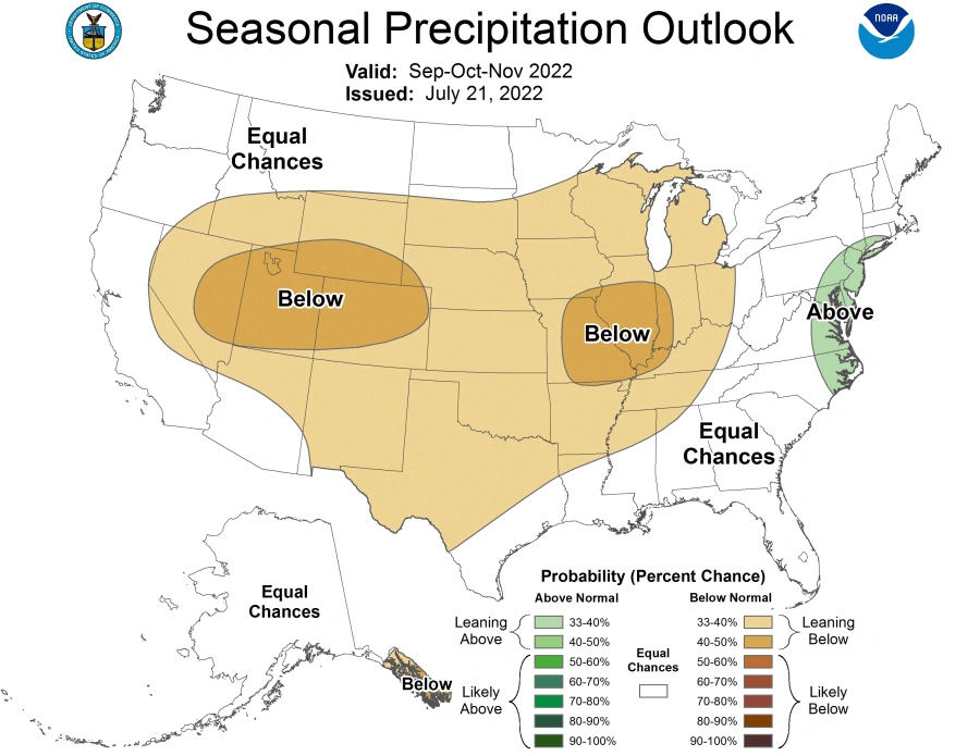
The National Oceanic and Atmospheric Administration is predicting an 80% probability that La Niña conditions will persist between September and November.
During the fall months in a La Niña year, the majority of North Carolina tends to receive more rainfall than average. This year, the Climate Prediction Center is forecasting an equal chance of a wet, dry, or normal season in the Piedmont. The North Carolina coast has the best chance at above-normal rainfall amounts this fall.
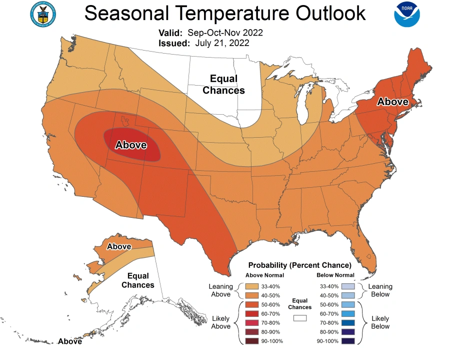
When it comes to temperatures during a La Niña year, the majority of the country is known to see warmer-than-normal temperatures. Heading into Autumn, there’s a good chance that most of the country, including the Piedmont, will see above-normal temperatures.
According to the CPC, the Northeast and the Mountain West region have the best chance for above-normal temperatures from September through November.
With the majority of the country forecasted to see warmer temperatures and drier conditions this fall, NOAA is concerned with increasing drought conditions over the next few months. With ongoing drought concerns in California and Texas, the predicted warmer and drier Autumn ahead will likely lead to worsening conditions considering extreme to exceptional drought conditions are already in place.
Not only does La Niña impact fall temperatures and precipitation in the United States but it also impacts the Atlantic hurricane season.
La Niña years are typically linked with active and destructive hurricane seasons. The reason for the link is due to weaker vertical wind shear and trade winds as well as less atmospheric stability.
Vertical wind shear refers to the change in wind speed and direction between 5,000 and 35,000 feet above the ground. If there is strong vertical wind shear in the Atlantic, it can rip a developing hurricane apart and sometimes even prevent it from forming.
An example of past hurricane seasons that occurred during La Niña year include the 2020 Atlantic season. In 2020, there were a record-breaking 30 named storms as well as a record number of seven major hurricanes (category 3 or higher).
Another example of La Niña resulting in an active Atlantic season was in 2010. There were 19 named storms, 12 of which were hurricanes, and five of which were major hurricanes. Hurricane Earl resulted in $3.5 billion in damages in NC and Tropical Storm Nicole resulted in record-breaking rainfall, 22.54 inches, in Wilmington, NC that resulting in over 150 road closures.
Things to watch for in the Piedmont Triad this fall
With the CPC forecasting above-normal temperatures this fall as well as equal chances of a wet, dry, or normal rainfall season in the Piedmont, we’ll want to monitor drought conditions.
Another thing to watch will be hurricane season which is known to be most active in August and September but lasts through the end of November.
NOAA is still predicting an additional 11-17 named storms through the end of the season. Of those, they’re expecting six to 10 of them to strengthen into hurricanes.
Those in NC know that hurricane season is no joke. We’ll continue to monitor the tropics and any possible impacts for the state and the Piedmont Triad.


