
[UPDATE 10:30 a.m.] Storms Building in the Area of the Six Rivers Lightning Complex Today Worry Firefighters

Firefighters across northwest California watch the heavens apprehensively this morning as thunder clouds build and converge on the northwest corner of the state. A Red Flag warning is not only across the Six Rivers National Complex but across surrounding counties today and into tonight.
With calmer, cooler weather last week, crews have slowly built control over the multiple fires of the Six Rivers Lightning Complex that started in the last storm. Some residents of Trinity and Humboldt Counties have been able to return home.
Firefighters reached 23% containment on the Complex this morning which now is at 23,159 acresAnd, though in many ways, rain could be a blessing, the mud flows and flooding on the McKinney Fire in Siskiyou County just a few weeks ago show the downside of downpours.
UPDATE 10:30 a.m.: Six Rivers National Forest Service put out their morning update,
…
Fire activity was minimal overnight with no instances of fire spotting outside of the control lines. Crews conducted several successful strategic firing operations overnight and improved control lines using dozers and handlines to remove fuels. All control lines are holding well.
Campbell Fire
Residents in the Seeley Mc Intosh area were allowed to return home yesterday evening. Today crews will continue to strengthen fire lines and limit the spread of the main fire. Portions of Seeley Mc Intosh Road may be closed to allow the removal of hazard tress from areas near the roadway.Ammon Fire
Firefighters will conduct strategic fire operations along the southwest perimeter along Hayden Road and in Friday Ridge area. Crews will continue to improve and reinforce fire lines along the Six Road of Ammon Ridge and within the Friday Ridge System.
Below we’ve gathered the most important information about the Six Rivers Lightning Complex Fire and organized it below for our readers and we’ll be keeping our eyes on what’s happening and updating throughout the day in green.
Stats:
Yesterday’s stats from Cal Fire are:

Today’s stats from Cal Fire are:

The extra equipment will help prepare for today’s possible storm.
Compelling Images:
California: Nighttime drone firing operations on the Six Rivers Lightning Complex. The Complex is now over 21,900 acres and 19% contained. Thanks to the Substack subscriber who sent this 🎥 in.#california #cai #calfire #hotshots #sixriverslightningcomplex #wildfire #fire #drones pic.twitter.com/fkP353dWnz
— TheHotshotWakeUp: Podcast (@HotshotWake) August 16, 2022
The Plan:
The Weather:
A Red Flag Warning has been issued for both Humboldt and Trinity Counties today. There is a chance that that there could be lightning and if storms develop near the Complex, expect erratic winds which could challenge firefighters.
The Roads:
Hwy 299 and Hwy 96 is open but please keep your eye on Caltrans QuickMap for the latest information.
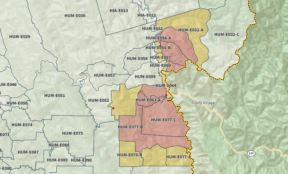
The following roads into evacuation zones have been closed. (Please note we believe more rural roads have been closed but don’t yet have accurate information. These are just the ones we know for sure.) According to InciWeb,
According to Six Rivers National Forest, the following roads leading to evacuation zones have been closed (residents may use these roads to exit only):
-
-
- Seeley McIntosh Road between Country Club Road and Campbell Ridge Road
- Campbell Ridge Road from Salyer Heights to Seeley McIntosh Road
- Horse Linto Creek Road at Saddle Lane
- Friday Ridge Road at Route 6
- Titlow Hill Road (Route 1) at Horse Mountain Botanical Area–Due to a large presence of fire personnel and machinery working to build containment lines for the Ammon Fire, residents are asked to limit travel on Titlow Hill Road/Route 1 in zones HUM-E052 and HUM-E062 to essential traffic only.
-
The Maps:
- Operations Map –to see details either zoom or click on the map and download a pdf.

- KMZ Map–Zoom for detail or for 3D imagery, click on the map and download a file that connects with your Google Earth program.


Evacuation and Meeting Information:
- Click here for the latest evacuation information from Humboldt County
- This is the latest Humboldt County Evacuation Map as of 8 a.m. on Wednesday, August 15. However, click the map to go to the latest information on ZoneHaven.

- Click here for the latest evacuation information from Trinity County
Earlier:
- Six Rivers NF Lists More Fires] Lightning Storm Peppers Northern Humboldt, Multiple Fires Reported
- Humboldt County Office of Emergency Services Issues an Advisory to Willow Creek Area After Multiple Fires
- Evacuation Orders Issued for Residents east of Willow Creek by HCSO and Evacuation Warnings Issued for Residents Near Salyer by TCSO
- Evacuation Orders and Warnings Expand as of 7:36 p.m. for Residents of the Willow Creek Area
- Over 500 Acres Burning Around Willow Creek This Evening as Latest Info on the Six Rivers Lightning Complex Released
- Six Rivers Lightning Complex Grows, Threatening Homes and Forcing Evacuations
- Trinity County Sheriff’s Department Issues Evacuation Orders For Areas Near Salyer
- New Evacuation Warning Issued for North of Willow Creek
- Humboldt County Issues New Evacuation Orders at 7:37 p.m.
- Six Rivers Lightning Complex Doubles in Size, 0% Containment
- More Evacuations Ordered This Morning as the Six Rivers Lightning Complex Takes New Ground
- Evacuation Orders Issued Sunday at 6:30 p.m.
- New Evacuation Warnings Issued Sunday by the Trinity County Sheriff’s Office at 7:52 p.m.
- HCSO Issues Evacuation Order for Zone South of Willow Creek
- Six Rivers Lightning Complex Expands to 6,773 Acres
- Six Rivers Lightning Complex Grows Several Thousand Acres and Is the Number 1 Priority in the State Right Now (PHOTOS)
- Steady Growth and New Evacuation Warnings: Six Rivers Lightning Complex August 10
- Six Rivers Lightning Complex Continues to Expand
- Firefighters Face Hotter and Drier Weather on the Six Rivers Lightning Complex Today
- Good News from HCOES
- Evacuate! New Order Issued on August 12 at 5 p.m.
- Trinity County Reducing Salyer From Evacuation Order to a Warning
- Law Enforcement Searching for Suspects in Willow Creek
- Law Enforcement Seeking Looters in Willow Creek
- Good News as Firefighters Claw Out 12% Containment on the Six Rivers Lightning Complex
- Captured! HCSO Arrests One Suspect in Yesterday’s Looting of a Property Under Evacuation Order
- ‘Secure and Hold,’ Firefighters Strengthen Their Grasp on the Six Rivers Lightning Complex
- Six Rivers Lightning Complex: 10 Days Nearly 20,000 Acres
- Six Rivers Lightning Complex Now the Second-Largest Fire in California This Year
Join the discussion! For rules visit: https://kymkemp.com/commenting-rules
Comments system how-to: https://wpdiscuz.com/community/postid/10599/
Heroes with Pulaskis n hot saws…. God Bless Em!
Southern Orygun is getting hammered right now (7:20pm 8/17). Started SE of Medford… now the thunderstorm is between Medford and Roseburg.
230 am wallop of a lightning storm with 1/2″ of rain in 40 minutes.