

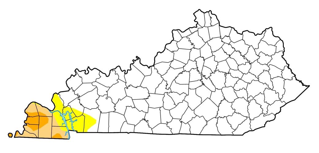


FRANKFORT, Ky. (KT) – The weekly U.S. Drought Monitor report issued on Thursday shows the part of Kentucky that is still considered to be in drought has shrunk and is now primarily confined to the Land Between the Lakes area and points west.


Data is collected every Tuesday morning and the report issued on Thursday morning, so any precipitation that fell after this past Tuesday will not be included until next week.
Every category in the drought monitor has improved over last week, from the percentage of the state that has no drought condition, to those in extreme drought, which is labeled as D3, in the scale that runs from D0 (abnormally dry) to D4 (exceptional drought).
In Kentucky, 90.17% has no drought, up from 86.62%. The abnormally dry area is 4.39%, which is down from last week’s 4.63%. Moderate drought (D1) has dropped to 3.55%, where it had been 5.15%. Severe drought (D2) areas are down to 1.88% from last week’s 3.43%. The extreme (D3) drought area, which was at 0.18% on the August 4 report is now gone.
Seven counties remain in either moderate or severe drought, which is a decrease from the 12 counties contained in last week’s report.
Richard Tinker with the National Weather Service says, “Over the past week, many areas from the Mississippi River eastward through the Piedmont and Middle Atlantic States recorded moderate to heavy precipitation. Most areas from southern Missouri and northeastern Arkansas through central Illinois recorded over 1.5 inches of rain, as did parts of the Tennessee and southern Ohio Valleys. Numerous patches of land across the Upper Midwest, the middle Mississippi Valley, the Ohio Valley, and the Gulf Coast east of Texas received over 3.5 inches of rain, with isolated totals of 6 to locally 11 inches reported in a swath from the middle Mississippi and lower Ohio Valleys northward through the Upper Midwest and western Great Lakes.”
Tinker says the next five days will be cooler and drier than normal, but for the six- to 10-day period, “Wet weather is only slightly favored from the lower Mississippi River to the southern Atlantic States and across the Appalachians. Odds significantly favor below-normal temperatures across the Ohio Valley and Central Appalachians.”
The Drought Monitor is produced jointly by the National Drought Mitigation Center at the University of Nebraska-Lincoln, the National Oceanic and Atmospheric Administration, and the U.S. Department of Agriculture.