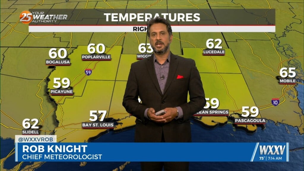
8/10 – Rob Knight’s “HEAVY RAIN THREAT” Wednesday Morning Forecast
At the risk of sounding repetitive, another day of high rain chances is on tap for the area. Once again, these storms can easily produce hourly rainfall rates that will be capable of causing flooding issues. Short term models are consistent on showing this activity likely beginning earlier than yesterday with some heavy rainfall moving into the Mississippi coastal counties around daybreak before filling in more across the area by the afternoon hours. While it is very likely that some areas see heavy rainfall, the somewhat chaotic setup to the rainfall has been helping keep the problem areas to a minimum. That said, deep tropical moisture associated with a tropical wave and persistent onshore flow will surely keep the level of concern elevated. The entire forecast area is outlooked for a slight risk of excessive rainfall through today as storms that develop today could once again easily produce rainfall rates of 2 to 3 inches per hour.
Much of the same is expected tomorrow as a boundary currently situated over the southern Plains moves toward the area, potentially helping to act as a focus for the rainfall should it make enough progress. Once again the potential will certainly be there for heavy rainfall with the locations being much harder to pinpoint. The area is outlooked for a marginal risk of excessive rainfall for tomorrow but could certainly be upgraded given rainfall that occurs today.
In addition to the rainfall concerns, a coastal flood advisory remains in effect through midday Thursday due to the persistent onshore flow. This is mainly for issues that may develop during the normal high tide periods. High pressure over the central Rockies will slide slightly east and south by the end of the week. This will place our area on the eastern periphery bringing a period of northerly flow into the area. Due to this, the focus for the shower and thunderstorm activity over the weekend will shift somewhat from a heavy rainfall threat to more strong storms with wind gust potential. Rain chances should moderate back to more normal summertime expectations as we move into next week as the ridge moves closer to the area.