
While attempting to better understand one of the more complicated public issues in Colorado — the allocation of water — I happened upon a map posted on the Southwest Basins Roundtable website, showing the various watersheds in the southwest corner of Colorado.
The San Juan River drainage; the Piedra River drainage; The Pine River drainage; the Animas River drainage; and so on…
Eventually, all these rivers flow into the Colorado River — which flows into Lake Powell, and then into Lake Mead, and ultimately, serves farms and cities in California, Arizona and Nevada.
Mostly, California…
California… the world’s fifth largest supplier of food, cotton fiber, and other agricultural commodities. In the U.S., California is the number one dairy state… and it’s the fourth largest wine producer in the world. The state produces over 90% of the wine in the U.S.
(As I write this, I am in fact sipping some California wine.)
The current drought in the American Southwest is of particular concern to farms and cities in California… but less of a concern in Pagosa Springs, situated at the headwaters of the San Juan River where, practically speaking, we have ‘first dibs’ on the cool, clear water coming out of the San Juan Mountains.
Of course, the water isn’t always cool and clear. At the moment, the roiling San Juan River is rather muddy, due to recent rainstorms.
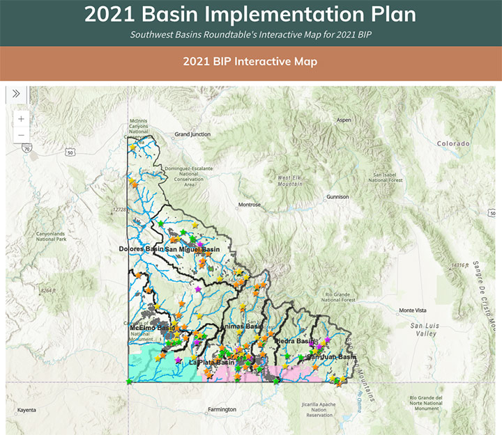
But to get back to the Basin Roundtable map. It’s one of those remarkable ‘interactive’ digital maps that allow you to zoom into the landscape to get ever-finer detail, and you can click on a link to open the map in a ‘full-screen’ version.
For a researcher interested in water issues, this map opened up a pathway to data to which I’d never before had convenient access.
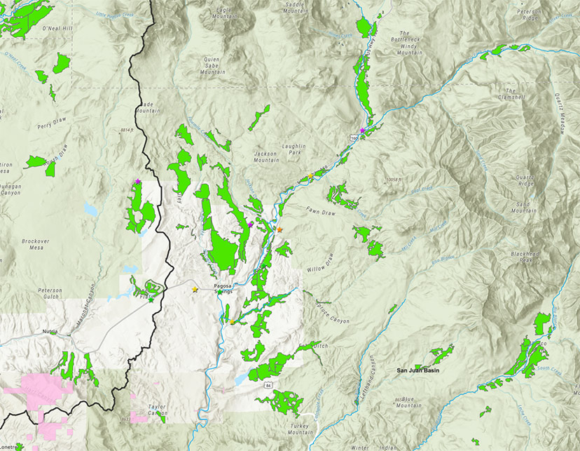
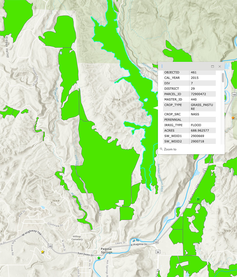
Below is a zoomed view of the area around Pagosa Springs. The green areas are irrigated ranches that pull water out of the San Juan River and its tributaries.
The colored stars — yellow, orange, purple, green — indicate water projects that the Colorado government has found suitable for taxpayer funding, either recently or in the future.
According to the U.S. Geological Survey, irrigation in Archuleta County diverts about 47,000 acre feet of water annually, mostly to grow grass. That’s about 15 billion gallons of water per year, or about 96% of the water diverted each year in Archuleta County.
For comparison, the residents and businesses served by the Pagosa Springs Water and Sanitation District (PAWSD) use a total of about 1,300 acre feet per year… about 3% of the water diverted from the river each year.
Disclosure: I currently serve on the Pagosa Area Water and Sanitation District (PAWSD) board of directors, but this editorial reflects only my own personal opinions, and not necessarily those the PAWSD board as a whole.
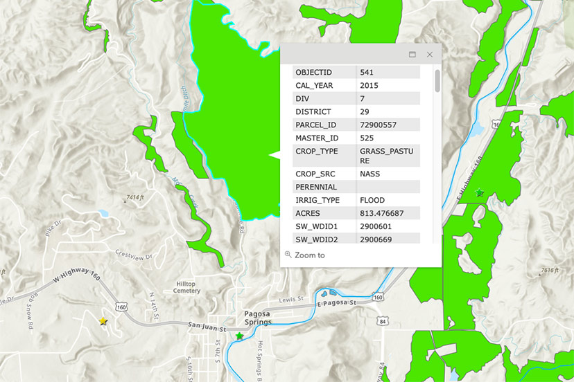
Zooming in a bit closer on the map, we can click on the largest irrigated ranch near downtown Pagosa Springs, located north of Highway 160, east of Fourmile Road and west of Snowball Road.
The map tells us that this ranch measures about 813 acres, and that it uses ‘flood’ irrigation. The crop is grass.
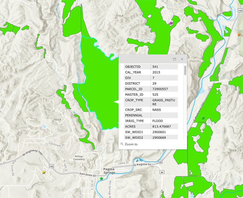
Flood irrigation is an agricultural technology that dates back to about 6,000 BC. You could, if you wanted, apply the word ‘primitive’ to this technology.
You would probably not use the word, ‘modern’.
The second largest ranch near downtown Pagosa Springs stretches north along Snowball Road, and appears to measure about 689 acres. It also uses ‘flood’ irrigation, and also grows grass.
Someone could probably tell us how many million of gallons of San Juan River water these two large ranches use annually, to grow grass using flood irrigation. I am not the right person to make an accurate estimate, but I can venture a wild guess.
Comparing the size of these two ranches to all the other ranches shown on the Roundtable map, I would guess that these two very large ranches, by themselves, use about 15% of the community’s agricultural water.
That’s a wild guess. If it’s close to being correct, then these two ranches — by themselves — use about five times as much water as all the PAWSD customers put together. Using ancient irrigation technology.
Speaking of technology, I find it slightly amazing that a team of people have produced an online digital map that puts this amount of information — about the agricultural use of water, in particular — into an easy-to-use, visual format. And that they’ve made this data available, for free, to the general public.
Which is not to suggest that most people are interested enough in water issues to spend time exploring this web page. For most of us in Pagosa Springs, water is basically a liquid that comes pouring out when we turn on the tap — and something for which we pay a relatively small monthly fee to PAWSD. (Sometimes forgetting that we also pay property taxes to PAWSD.)
As noted, the map includes colored stars, located here and there, which indicate tax-funded water projects, either current or planned. We find six such ‘starred’ projects in the vicinity of downtown Pagosa Springs, including — in the center of downtown — the Geothermal Greenhouse Partnership growing domes located across the river from the Springs Resort.
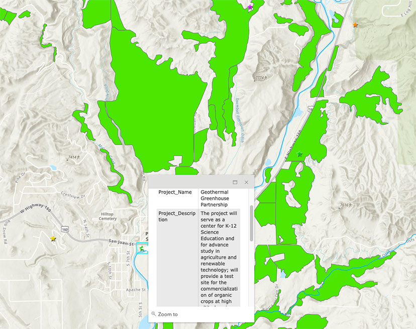
If you click the GGP star, the map includes a link to a 14-page ‘Final Report’ on the GGP growing domes. The report starts out like this:
The Geothermal Greenhouse Partnership Project in Pagosa Springs is complete (2015-2020) with regard to the expenditure of CWCB funds from the Water Supply Reserve Account Grant Program. The overall objects of the Project have been accomplished:
- Prepare substructure for installation of water infrastructure outside and under greenhouse sites
- Install water infrastructure outside and under greenhouse sites
- Complete water infrastructure inside the three greenhouses
The total Project includes three 42-foot agricultural greenhouses heated by geothermal and solar energy (including a newly installed array of solar panels), grounded in permaculture or aquaponic practices, surrounded by beds, walkways and public seating area (including an amphitheater), and graced by a newly installed pollinator/native plant garden – all centrally located in downtown Pagosa Springs at Centennial Park.
Although the three domes have been built and two have crops growing inside, I have the impression — as a downtown resident who walks past the domes on a regular basis — that the nonprofit GGP partnership struggles to find enough volunteers to manage its proposed mission of providing educational programs and ‘high-tech’ experimental food production.
That aside, one of the sites on the map of interest to me, as a person currently serving on the PAWSD board, is the Dry Gulch Valley.

Bill Hudson began sharing his opinions in the Pagosa Daily Post in 2004 and can’t seem to break the habit. He claims that, in Pagosa Springs, opinions are like pickup trucks: everybody has one.