Pittsburgh Weather: Scattered storm chances kick-off Fourth of July Weekend
PITTSBURGH (KDKA) - If you've checked in with NOAA's Storm Prediction Center, you are aware that we technically have a marginal storm risk today. The risk of storms peaks Saturday morning around sunrise but they still consider this time 'Day 1' with a 6 a.m. cutoff.
WEATHER LINKS:
Current Conditions | School Closings & Delays | Submit Your Weather Photos
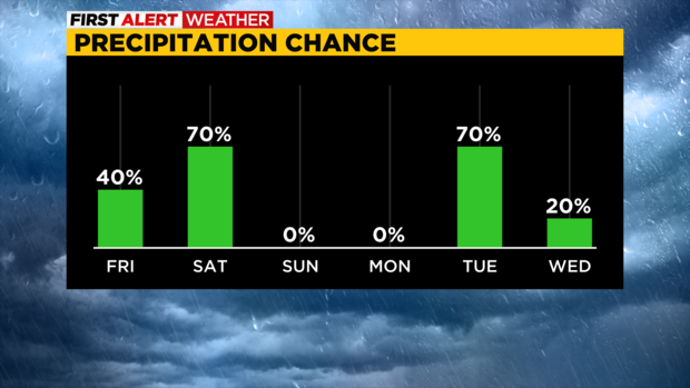
Today will see plenty of morning sunshine, and partly to mostly cloudy skies for the afternoon. There will be a chance for isolated to scattered rain and storms through the day. Right now it looks like your storm chance will be highest from 9 a.m. until 3 p.m. with places south of I-70 having the best chance of seeing rain and a thunderstorm.
Storms today will have the potential for frequent lightning, but they will not last long as they pass by.
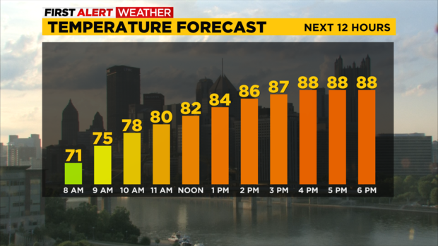
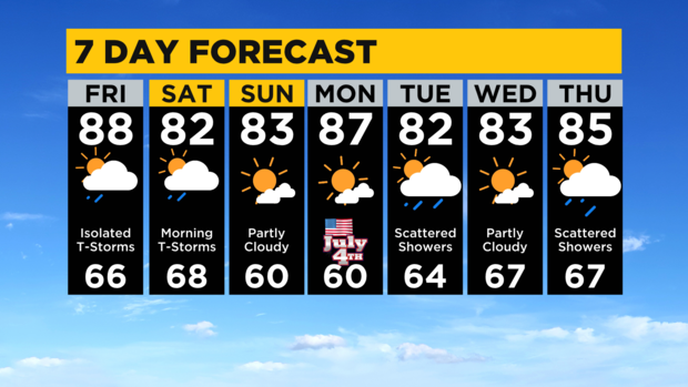
I have today's highs hitting 88 degrees with the lack of rain. Morning temperatures are in the mid-60s. I am forecasting a noon temperature of 82 for Pittsburgh. Winds this afternoon will be out of the southwest at around 10mph.
Storm chances again peak on Saturday morning as a cold front blows through. Most of the time storms moving through at this point are losing their severe weather features (winds weakening, cells lacking enough strength to maintain large hail) with heavy rain and frequent lightning continuing.
The NAM 3k does show the system maintaining at least a chance of strong winds as it rolls through. This is why we are at a marginal severe risk at this time as the line of showers will be weakening but still potentially severe as it is set to arrive and move through. Rain totals for today and tomorrow will likely be below 0.3".
That's down from the half-inch I had been forecasting for the event.
Looking at the rest of the holiday weekend, Highs on Saturday will still reach the low 80s behind the front and it is looking overcast through at least 4 p.m. on Saturday.
Sunday will be dry with a high in the low 80s.
Monday will see a warm-up with highs in the upper 80s.
I am seeing data starting to show numbers supportive of 90s on Monday. I am holding off for now but expect a hot and steamy one for the Fourth.
Stay up to date with the KDKA Mobile App – which you can download here!