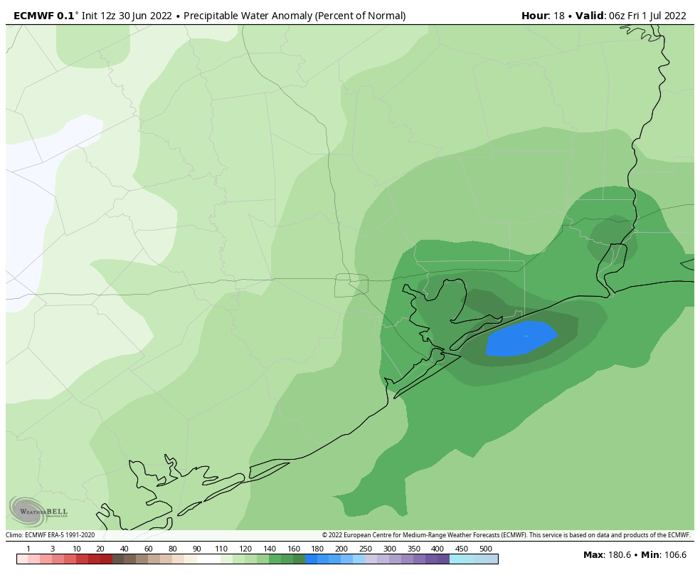
Good afternoon. With this post we will provide an update on rainfall expected tonight and Friday, before our region dries out and starts to heat back up this weekend. The bottom line: We are maintaining a Stage 1 flood alert for coastal counties through Friday. The biggest change in this afternoon update is that our area of greatest concern has shifted eastward: We now expect the heaviest rainfall from now on to be focused on Galveston Bay and points eastward.
As expected, the rainfall today has been largely focused along the coast. Whereas most of the metro area north of Interstate 10 has not seen more than a few stray drops, parts of Galveston Island have received as much as 4 inches. This trend is largely expected to continue as a tropical system moves northward, continuing to push a river of atmospheric moisture on shore. Because we expect such a wide variance in outcomes, let’s break the forecast down for two different areas: the coastal counties of Galveston, Chambers, and Orange; and everyone else, including Houston.
Galveston, Chambers, and Orange counties
Forecast modeling has zeroed in on these areas bearing the brunt of heavy rainfall, most likely from about midnight tonight and running through Friday afternoon. Locations in these counties may see between 2 and 8 inches of rainfall during that time period, and despite the dry soils the most intense rainfall rates will nonetheless quickly back up streets. (This kind of tropical moisture is capable of producing intense rainfall rates of 2 to 4 inches per hour.) If you live in these areas, you should definitely check the radar before getting on the road tonight and Friday. While things may be fine, there’s also a chance they might not be. The worst should be over some time on Friday afternoon.
Houston, Harris County, and other parts of the metro area
For everyone else the rain showers are likely to be far more spotty, and the impacts minimal. Expect a day on Friday to be pretty much business as usual. While we could see a few areas away from the coast pick up some significant rain accumulations, it would not surprise me to have much of the inland parts of our region stay below one-half inch of rain. This is especially true for locations inland of Highway 59/Interstate 69. It just looks like the moisture is going to get shunted off too far to the east to really provide meaningful rainfall to those areas. I know, our lawns and trees could certainly use a lot more.
If needed, Matt will have an updated forecast later tonight. If not, look for a post early Friday morning to catch you up on the latest.
So between Galveston and Houston are a couple other counties like brazoria?
Brazoria is west of Galveston.
There are no counties in between Houston and Galveston. Brazoria County is south of Houston and west of Galveston.
Why is Brazoria County not included in this report?
So much for all these 60% forecasts.
Not what my trees were hoping for on the westside. Buh.
This is not the forecast I wanted but I just wanted to thank you for providing better and more accurate forecasts than the news stations. At no point did you hype up this rain event and have been very cautious with your forecasts for rain. This is in stark contrast to KHOU which has been hyping many inches of rain for the entire week and the forecast is likely to be a huge bust. Definitely appreciation your realism over the fake hopium KHOU was handing out on a daily basis.
I think the chance woodlands gets any rain is less than 50% and everything will miss to the East. This is very bad news for the drought with first half of July with almost no rain chances.
Re-Starting my sprinklers as we speak!
This is why I rely on Weather Bell analytics. You two aren’t any better than the NWS forecast regurgitators appearing on Channels 2, 11, 13 and 26 in the Houston Metro area.
You’ll be missed.
Not really sure why you are following Spacecityweather, if you are disappointed in their forecasting.
Their map with rainfall accumulation is from Weather Bell.
Cool that you came here just to say that.
This is an interesting divergence, because as of right now (I just looked), National Weather Service is forecasting 2.21″ for my area (Champions, up by FM 1960) now through Saturday morning. This is way more than you guys. I’m inclined to believe you guys over NWS.
Not a drop today in Meyerland area. (We did get the good downpour a few days ago). Weather apparently is hard to predict. Clouds kept the heat down- that’s the only good thing to say about it.
Any amount of storm surge expect with a storm like this, or are the winds not strong enough?
Good analysis—tough situation to nail down but the models are showing most rain east of Houston. As a old meteorologist (Texas AM-79 and AF for 24 years) the forecast has been bad for south MS where I currently reside. My daughter lives in the Heights and tuned me on to your reports several years ago-y’all provide excellent insights!
Too bad. Some trees are starting to drop leaves here near Atascocita/Lk Houston. Might be getting ready to lose more trees if July remains dry as well.