Next Weather: Humidity set to drop dramatically Saturday
MINNEAPOLIS -- After days of stifling heat and humidity earlier this week, both are finally set to back off going into the crux of the weekend.
WCCO meteorologist Mike Augustyniak says that Saturday morning could still bring some more showers, but by mid-afternoon those should have moved through.
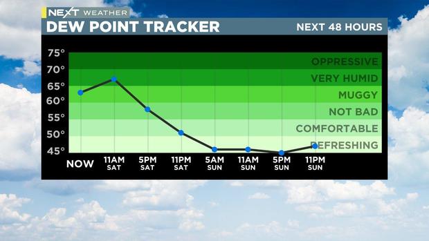
The dew point will make a dramatic plunge from "very humid" territory late Saturday morning, into downright refreshing by Sunday morning.
"Your next chance to open the windows (arrives) by tonight," Augustyniak said.
That said, Augustyniak said he expects it to be somewhat blustery Saturday night and Sunday. Highs should reach 80 Saturday, but will only be in the mid-70s on Sunday before the next work week brings typical temperatures for this time of year, with highs in the 80s and lows in the 60s.
"We're still running low on rain, particularly in the Twin Cities," Augustyniak said. "in the last week 'abnormally dry' conditions were added to the drought monitor, as we run about 2.75" below average for the month of June."
There was plenty of severe weather overnight in the northern part of the state, with some additional flooding on top of what was already happening from the previous round of rain.