Google Street View just unveiled its new camera—and it looks like an owl
The device will hit the streets in 2023 and work alongside the company’s existing cohort of cameras.
Google Street View, a feature that has shown us the wonders and oddities of our world, is turning 15 this year. With over a decade of experience under its belt, and over 220 billion Street View images from more than 100 countries and territories in its catalog, the team is ready to debut new projects and reveal the prototype for a lighter, more transportable camera coming in 2023.
Street View’s two main sources of photos are by car and by human trekker. The car mainly maps the streets, while the trekkers go to locations that are hard to drive to, like the bottom of the Grand Canyon or the top of Machu Picchu. But there are other assets that Google uses off the beaten path too, such as a flock of sheep that helped capture the Faroe Islands.
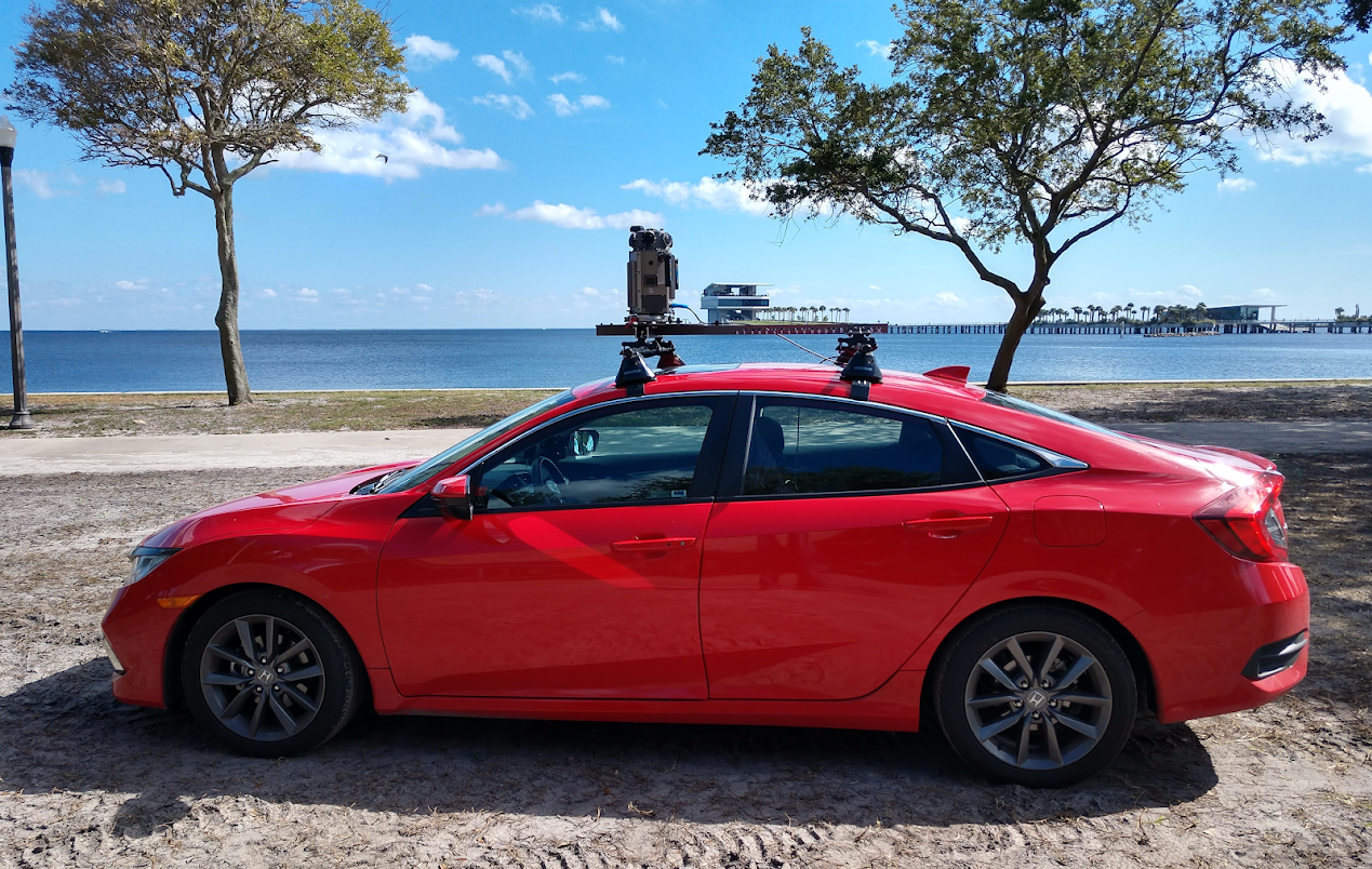
The new camera looks a bit like an owl and compresses all the properties and capabilities of the current version of the car camera into a 15-pound device. Comparatively, the car system they use today is about 150 pounds, and the trekker system carried by a person weighs 45 pounds.
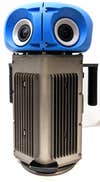
Right now, atop the Street View Car is a rosette-shaped ball of cameras that peer out and take in imagery from different vantage points. “That allows us to take an image of the world as if you were standing in the street,” says Steve Silverman, the technical program manager at Google Street View. “We made the cameras from the very beginning to mimic what we can see with our eyes.” In addition to cameras, the cars also have a photo processing center, lidar sensors that measure distance with laser beams, and an inertial mapping system with gyroscope and GPS.
[Related: How to hide your house on every map app]
The data that’s gathered is stored on a disc on board. Then it’s relayed at a “data ingest site,” where faces and license plates are blurred in a way that can’t be undone. After that, the data goes in a processing pipeline that stitches the images from the various cameras pointing in different directions into a cohesive 360-degree view that’s like if one camera was seeing everywhere at once. The team also color corrects, and locates the image’s position on Google Map, which will appear as dots that show you where Street View images are available.
The new cameras are aimed at expanding how much of the world Google can access and increasing how often they can update their data. The camera is also modular, which means that the team can also add or take away components like lidar as needed, so they don’t need to build a camera system from scratch for every type of imagery they want. “With the current Street View cameras, they’re designed to be put on top of a particular car, so it’s quite an achievement for us to be able to take one of these cameras and put it on top of any car with a roof rack,” says Ethan Russell, director of product at Google Maps. “That means that we can easily ship these cameras around the world. That allows us to both expand our reach and make sure that we can refresh the imagery more easily. Because we have flexibility about the cars we can put these on, this can help us build a more sustainable Street View fleet with cars like plug-in hybrids or fully electric cars.”
Besides our world, Street View has also taken a trip to the space station. Google worked with NASA to train astronauts on how to collect 360 degree imagery on the space station.
“In general, we look at places around the planet, world wonders, sites that are difficult to get to for some people, and we want to make those experiences available,” Silverman says.
Accruing a massive collection means that the Street View team can experiment with added features, too, like Live View, Immersive View, and Air View.
[Related: Google I/O recap: All the cool AI-powered projects in the works]
The augmented reality function in Google Maps, called Live View, is built on top of Street View. It compares the library of Street View images to the scene seen through your phone’s camera. Using that, Google Maps can figure out where you are, what direction you’re facing and what you’re looking at, allowing it to render arrows on the sidewalk that tell you which way to go, or labels on important businesses in your viewport. This function is still available even in conditions where GPS signals can be murky or get lost (like around tall buildings or in areas with no clear view of the sky).
“This is all possible because Street View understands so much of the world,” Russell says.
And Immersive View, a new feature announced at I/O this year, was built by combining Street View and Aerial View images together into a photorealistic 3D model of the world.
“If you’re going for a vacation in London, we can take you to Westminster, we can show you Big Ben and the London Eye. And then we can overlay information on top of this model of the world including current traffic, or weather, and allow you to play with different lighting and see what it looks like in the morning versus the evening,” says Russell. “And then when you want to look for restaurants, we can swoop you down to the street level and take you inside of restaurants and show you the ambiance. This only works when you have high resolution imagery that actually reflects the state of the world.”
