
Showers and thunderstorms will return to South Arkansas today as several upper-level disturbances move into the region.
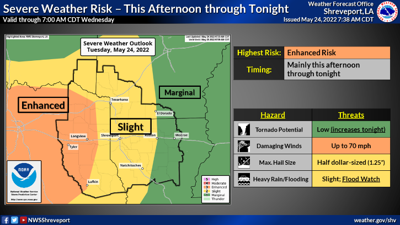
The National Weather Service in Shreveport said some of this activity may become strong-to-severe by this evening, with all modes of severe weather possible.
Heavy rainfall will also be possible by this evening, which has resulted in a flash flood watch for the entire Four State region.
Heavy rain, along with a marginal risk for severe weather, will continue into Wednesday, as additional disturbances and a cold front move across the region. Total event rainfall amounts of 2-4 inches, with isolated higher amounts, are possible. Dry conditions will return by the end of the work week and through the first of next week.
magnoliareporter.com has recorded 5.47 inches of rain in May, and 22.6 inches since January 1, plus 1.25 inches of snow. Through the same period last year, the news website recorded 29.33 inches of rain and 10.25 inches of snow.
The flood watch is in effect through Thursday morning.
Excessive runoff may result in flooding of rivers, creeks, streams, and other low-lying and flood-prone locations.
Creeks and streams may rise out of their banks. Flooding may occur in poor drainage and urban areas.
Rainfall totals of 2 to 4 inches will be possible with isolated higher amounts.
The flood advisory includes the Ouachita River south of Camden. At 26.0 feet, low lying pastures and timber land along the river begins to flood. Sandy Beach Park at Camden starts to flood.
At 7:30 p.m. Monday, the stage at Camden was 22.8 feet. The river is expected to rise to a crest of 25.5 feet Tuesday evening.


