Last Updated on May 22, 2022 3:19 pm
NCZ001-018-019-221945-
Ashe NC-Wilkes NC-Watauga NC-
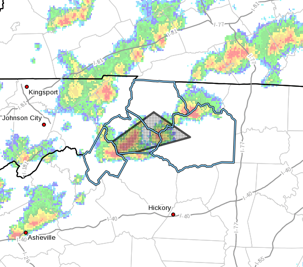
312 PM EDT Sun May 22 2022
…A strong thunderstorm will impact portions of
west central Wilkes, southern Watauga and south central Ashe Counties
through 345 PM EDT…
At 311 PM EDT, Doppler radar was tracking a strong thunderstorm over
Boone, moving east at 35 mph.
HAZARD…Winds in excess of 40 mph and penny size hail.
SOURCE…Radar indicated.
IMPACT…Gusty winds could knock down tree limbs and blow around
unsecured objects. Minor damage to outdoor objects is
possible.
Locations impacted include…
Boone…
Blowing Rock…
Foscoe…
Wilbar…
Deep Gap…
Todd…
and Blowing Rock In Caldwell County.
PRECAUTIONARY/PREPAREDNESS ACTIONS…
If outdoors, consider seeking shelter inside a building.
Locally heavy rain will quickly reduce visibility and result in
ponding of water on roadways, standing water in low lying areas, and
minor flooding of creeks, streams, and areas of poor drainage.
Drivers are urged to slow down and use extra caution to avoid
hydroplaning.