
GSSI Updates their UtilityScan® GPR System with New User Interface to Accelerate Workflow from Target Detection to Reporting
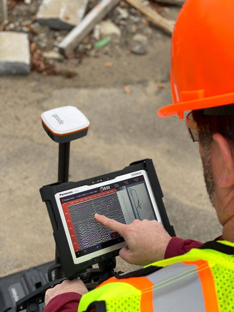
GSSI, the world’s leading manufacturer of ground penetrating radar (GPR) equipment, announces the updated UtilityScan® GPR system, with a new user interface (UI) that makes it easier than ever to locate and mark the depth of underground utilities in real-time in the field. With real-time target mapping, advanced scanning and identification capabilities, the rugged and flexible UtilityScan helps utility locating professionals accelerate workflow from target detection to reporting.
UtilityScan is ideal for marking the location and depth of subsurface utilities, including gas, sewer, and communication lines. Real-time target mapping features include a new Map Mode that allows users to trace their steps and gain a bird’s-eye view of their survey. Users can also simultaneously place APWA color-coded marks on 2D data and a geo-referenced map.
With the updated UI, users can collect and create 3D scans. The on-screen 3D data collection mode allows users to easily define the time slice depth and thickness in the field with the 3D data on the screen. The map window can be minimized to view the 3D display full screen.
The rugged, flexible system is rated IP65, with durable components tested to withstand the most challenging survey environments, including rain, dust, and extreme cold down to 4°F. The integrated Panasonic G2 tablet screen is designed for rain and glove use. For areas where Wi-Fi is prohibited, the system includes a rugged Ethernet cable that can be used for communication between the tablet and antenna.
UtilityScan is available with the optional LineTrac® power detection module, which enables identification and tracing of the precise location of underground electric and RF-induced utilities. This allows the detected power or induced frequencies data to be overlaid on the radar data, providing reliable positioning and target information. This system is compact and portable, only weighing 34 pounds.
For more information on the updated UtilityScan, email GSSI at [email protected]
About GSSI:
Geophysical Survey Systems, Inc. is the world leader in the development, manufacture, and sale of ground penetrating radar (GPR) equipment, primarily for the concrete inspection, utility mapping and locating, road and bridge deck evaluation, geophysics, and archaeology markets. Our equipment is used all over the world to explore the subsurface of the earth and to inspect infrastructure systems non-destructively. GSSI created the first commercial GPR system over 50 years ago and continues to provide the widest range and highest quality GPR equipment available today.
