Winter Storm Watch: Latest on Late Week Storm
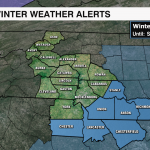
Winter Storm Watch in effect Thursday night through Saturday Morning.

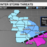
A cold front will bring widespread rain showers to the region Thursday. Colder temperatures flood the region as this boundary stalls to our south and east Thursday night. As of the latest model trends, a weak disturbance will ride along this boundary bringing wintry precip from the south to the north beginning Friday morning. The track and intensity of this piece of energy is further south and east which means more snow than ice, but lower totals across the board. The biggest impacts for the Carolinas will be for the coast where freezing rain and sleet will cause major disruptions along the NC/SC coast where .25-.50″ of ice accumulation will be possible. The highest snowfall totals will be for Raleigh-Durham, but even then 2-5″ of snow seems a bit aggressive as well.
A burst of snow and sleet will be possible south of I-85 late Thursday night. But, expecting if we see any wintry precip from this system it will begin as light snow and sleet for our South Carolina Counties early Friday morning. From there, precip will push north with an all snow event to I-85 by lunchtime with a few snow showers reaching the I-40 corridor by mid-afternoon. Locally the highest snowfall totals would be east of I-77 with 1-3″ for our eastern counties. South of I-85 snow totals will be 1-2″ with .1-.2″ of ice. Outside of light snow Thursday, the Mountains and foothills will miss out on any significant impacts from the system. Snow will wrap shortly after midnight Saturday.

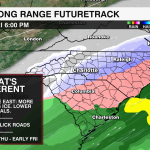
One thing to note in terms of impacts with this system is that there won’t be as much of an opportunity for any pre-treating of roads as we did for the preps we had for Sunday’s storm. The rain Thursday would wash that away. Travel woes will be felt hardest south and east of I-85 and I-77 with slippery roads.
This forecast is still very dependent on where the front stalls, and the intensity of this low. But, trends are bringing less impact to the region.