When Ellie Frymire was exposed to COVID-19 in mid-December, she knew she wanted to get tested at a city-run site rather than the overbooked urgent cares near her Park Slope apartment.
But the map on the city’s COVID-19 testing website didn’t include the New York City Test & Trace vans and tents dotting the city. Those appeared in long lists at the bottom of the page separated by borough, without a map to help users find the location closest to them.
Frymire, a software developer who specializes in data visualization, instinctively saw a design problem she could easily fix. After a couple hours’ work, she’d collected all the city-run testing sites from the website and mapped them herself. The resulting website, testingsites.nyc, has racked up thousands of views since it launched in mid-December, Frymire said.
“I wanted to create a map [of places] where people could go get tested for free, rather than find a private location where they could potentially have to pay,” she added.
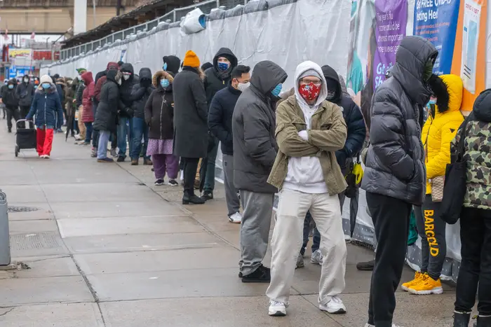
New York City’s map is frustrating for those used to easily finding the exact location of every restaurant, pharmacy, or tattoo parlor in their area. While local officials have doubled the city’s testing capacity to more than 200 sites in response to the omicron surge, more than half are mobile units and they’re not included in the map that headlines the city’s “testing locations” homepage, raising questions about its efficacy.
Instead, the city’s map directs users to urgent cares, private clinics and pharmacies. Some of those locations have closed due to staffing shortages; others may charge patients hundreds of dollars for a test depending on their insurance.
The map does include brick-and-mortar city-run testing locations, like the ones housed on NYC Health + Hospitals campuses. Though the mobile testing sites aren’t exactly kept secret, they’re less easy to find — tucked away at the bottom of the page below the map, listed on the NYC Health + Hospitals website and shared in PDFs on Twitter.
For people like Christine Callahan, a Greenpoint resident who gets tested regularly for her job in construction administration, the map may be the first and only centralized resource they see when searching. Callahan consulted the map in mid-December and found two testing sites near her office, a CVS and a Quest Diagnostics. On her lunch break, she visited the CVS, only to be told they hadn’t offered testing for months; she moved on to Quest but said she was told she’d need to make an appointment in advance.
“I don’t have the ability or the job flexibility to have an extended lunch,” she said. “That was a frustrating day.”
Ultimately, Callahan said, she had no choice but to pay $35 for a two-pack of rapid tests at a nearby pharmacy.
“The cost of doing that in that case was better than getting docked pay,” she added.
The map used by the city is created by a San Francisco-based health data company called Castlight. City and state health departments across the country have added the company’s map, which covers the entire United States, to their websites. Since the early months of the pandemic, it’s racked up 5 million unique visits nationwide, according to Castlight’s website. The company also helped build the Centers for Disease Control and Prevention’s VaccineFinder.
Lauren Timen, a spokesperson for Castlight, said the city-run testing sites on the map come directly from a file shared with the company by New York City Health and Hospitals (H+H).
“Because the mobile sites change often and are only open for shorter periods of time, NYC opts to have those listed out at the bottom of the page,” she added, which was confirmed by NYC Test & Trace Corps, a joint initiative of the city’s health department and H+H. Its spokesperson, Adam Shrier, said Test & Trace is able to make updates or corrections to the map as needed, and the map does include more than 100 non-mobile, city-run testing sites.
“Our number one priority remains providing New Yorkers with fast, accessible, free testing resources to make testing in every community as convenient as possible,” Shrier wrote in an email to WNYC/Gothamist, noting that the city recently re-upped its contract with Castlight.
According to an FAQ posted on the company’s website, the map is updated twice per week by state-level teams who call clinics and consult testing directories online. Castlight also provided a Google Form where users could propose corrections and new test sites, but it’s no longer open for submissions.
The city’s COVID-19 Information Portal website warns users that the map includes private testing sites and that some may charge for a test. It also instructs users to call ahead before they visit one of the testing sites listed on the map.
Frymire said her map requires daily updates — a more frequent pace than the Castlight map’s biweekly schedule. And WNYC/Gothamist found at least three other maps crafted by individual New Yorkers to document the city-run testing sites missing from the data visualization shared by the city.
Callahan, who struggled to find a city-run site, said she hopes the city will make its own map, one that includes its many mobile testing sites.
“I’m fully confident that there’s people in the city who are capable of making a map and maintaining it,” she said. “All people want is to feel safe and get the best information possible.”
This story originally misstated the number of non-mobile, city-run testing sites included in the Castlight map. The map includes 100 such sites, not 40.