
Can we use data to predict the future? In a way, yes—and it’s already happening. To understand how windstorms might affect a tree stand or how wildlife populations are changing, our crystal balls are less cloudy thanks to artificial intelligence.
Let’s take hurricanes, for example.
We don’t know the exact paths they’ll take to crisscross the Southeast each year, but we can make an educated guess.
To do this, we’ll need a few things. Start with gathering the ages of the trees, the content of the soil, maybe even additional vegetation growing there. We can also get meteorological data for the region and detailed satellite images containing millions of pixels of data—even information from multispectral images.
Got it—now what?
Just a few years ago, sorting through this pile of information to create a predictive model would be an impossible task. But as technology has advanced, so has its ability to parse out trends and “learn” from the data. Now, researchers at the Warnell School of Forestry and Natural Resources are at the forefront of using artificial intelligence in areas such as increasing tree stand productivity or tracking wildlife in a particular area.
As a result, we’re taking natural resources management to a new level. Here are a few ways faculty and alumni are answering big questions with “big data.”

No, that’s not a coffee table in Alicia Peduzzi’s office—it’s a molded black plastic case holding a state-of-the-art drone. Peduzzi, assistant professor of precision forestry, came to Warnell last fall as part of a UGA cluster-hire initiative to bring new researchers focusing on precision agriculture. She is using new technology to help forests be more productive, and the drone plays a large role in that.
Working with members of the Plantation Management Research Cooperative (PMRC), which is also based at Warnell, Peduzzi is investigating ways to use hyperspectral imaging to understand potential problems in the forest. For example, the high-resolution images her drone collects show trees in 260 different sections of the light spectrum. One of these sections might show forest health weaknesses not visible to the naked eye.
When this is collected alongside weather data, tree stand information and—well, any other variables you want to add to the mix—it creates an opportunity for modeling predictions.
“This is what we call big data, because now we need the help of a computer to figure out the relationship between all these different types and large amounts of data,” said Peduzzi. “We put all of that together, and we use an algorithm to process it. We use the ‘big data’ concept.”
Peduzzi is working with other experts at Warnell and across UGA to piece together data and then run it on a supercomputer on campus. “I pair with the experts in an area I intend to work with, and I give them my insights into how we can use imagery or LiDAR data to relate with what they collect on the ground.”
Associate professor Cristian Montes, co-director of the PMRC, also develops and refines models based on big data in collaboration with the forest industry. He has similar projects based in Mexico, Brazil, Colombia and Chile using country-level data.
“The thing that keeps me fascinated lately is that we’re now modeling not only how the trees are growing into the future, but also the risks associated with growing that plantation into the future,” said Montes, who debuted a new tornado risk prediction model at this year’s annual meeting of the PMRC. “To achieve all of these, we use a technique called machine learning. It’s the same type of technology that social media in your phone are using—they capture information about a subject, and once they have that data, they relate that data to someone’s interests and preferences.”
It’s technology that’s in use every day, whether it’s your social media feed serving you ads or a grocery store sending you coupons based on your previous purchases. Machines are quickly learning whether you will buy a Coke or a Pepsi the next time you stop at a convenience store.
Montes and his colleagues want similar results for forests. “As long as I have a particular amount of data from a forest stand, I can determine if that stand is going to buy a Coke or a Pepsi,” he added, laughing.
“The thing that keeps me fascinated lately is that we’re now modeling not only how the trees are growing into the future, but also the risks associated with growing that plantation into the future.”
– Cristian Montes, associate professor of natural resource biometrics and timber management
But right now, this work is still largely experimental. Jason Little (MFR ’03), director of valuation services for Forest Resource Consultants, said the forest products industry is used to dealing with large data sets, but the concept of “big data”—creating predictive models from layers of information—is still in its infancy at the commercial level.
He said less than five years ago he saw spatial technology beginning to emerge as a tool for measuring forest inventory. But the process was expensive and only the largest companies were experimenting with it. That type of data is a difficult sell when you can easily get tried-and-true measured data from the ground.
“The more that technology is reliable and people can trust it, the bigger the data sets are going to get in forestry,” he added. “We’ve been talking about a way to come up with inventorying virtual stands and using satellite technology, and nobody’s really figured it out yet. So, it still takes somebody walking the woods and putting in a plot and measuring it.”
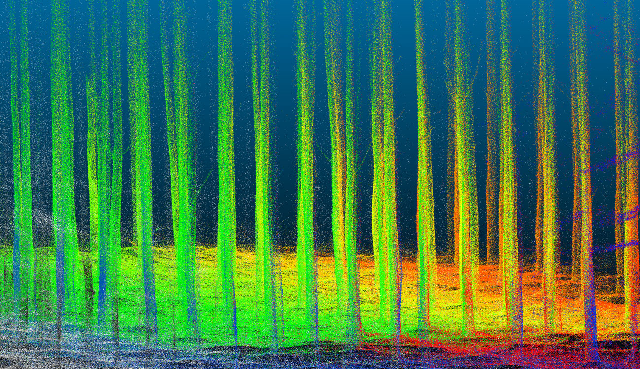
Kris Reyner, forest analyst with RMS, said the processing power required of big data also keeps companies from jumping on the early adopter bandwagon. For example, as LiDAR gains a foothold, companies struggle with how much manpower to put behind evaluating the data it collects.
“Just simply storing it—hundreds of terabytes of data is enormous amounts of data,” he said. “LiDAR can give you a pretty good estimate of the diameter, but that quality piece? That’s the piece that’s not there. It gives us a lot, but it still can’t see through all the clutter.”
When you’re evaluating a tree stand to gauge its value in five, 10 or 20 years, it’s critical to work with methods you know have worked in the past. He and Little agree, though, that as the technology advances, there’s value in continuing to have people in the woods evaluating trees. In the future, the data they collect can contribute to earlier decisions in the field, positively affecting the value of the timber.
“When you look at, say, 1990 to now, we’re light years ahead of where we were compared to the types and quality of data that we track,” said Little. “Ultimately, data drives how the forest looks and the decisions you make in the future. If you don’t get the starting data right, you’re never going to get a projection on a stand right. It’s such a crucial part of our business.”
But if big data can play a role in determining risk, models developed by Peduzzi and Montes could be a boon to landowners. The ability to predict the chance a forest might develop a disease or be in the path of a tropical storm could be an essential tool in a forester’s toolbox.
Montes is hopeful that’s the case. Already, PMRC members are implementing models he and his students have developed—and they are working on others. Traditional, or “static,” models contain some risk forecasting, but the analysis is based on a small area. “Now, with machine learning, I can incorporate not only the information from one particular stand, but also the information from all its neighbors to better forecast its future yield,” he said. “We were never able to do that before.”

On the hunt for gobbles
Johnathan Samples is keenly aware of the amount of data floating around, but it didn’t hit home until he started to get into hunting. That’s when his phone began to ping.
After setting up a wildlife camera on his property, he began to get text alerts whenever the camera thought it saw an animal. Over and over and over, whether there was an animal or not.
“I kept getting text after text, and thought, ’There has to be a better way to filter this.’”
As a software designer by trade, Samples, whose daughter recently graduated from Warnell, started thinking about ways to streamline the process. He began working with cellular cameras and developed artificial intelligence software that could learn to discern an animal in an image—and gets smarter with each image uploaded to the cloud. The result is a patented platform called HuntPro that automates and enhances trail camera surveys through artificial intelligence-powered image recognition and “big data” technology. Warnell alumnus Rans Thomas (BSFR ’99) also serves as a consultant on the project.
As more hunters and wildlife enthusiasts subscribe to HuntPro, the smarter the platform gets. This is the key to building any kind of accurate probability model: Large and diverse data. It’s the same idea behind a very specific tool now in use by Warnell professor Mike Chamberlain to identify turkey gobbles. Similar technology is also being developed by fellow faculty members James Martin and Richard Chandler for other bird species.
“I was paying 10 undergraduate students to process data, and it was taking us over a year to get the previous year’s data done,” said Chamberlain, whose software uses a similar A.I. concept but was originally developed by a researcher at Texas A&M University to identify species of algae. “Well, now we’ve created a machine-learning tool that is able to do it, and the only reason we’re able to do it is because we have so much data that we can train it.”
Now, what used to take months to listen and process now takes a matter of hours. Researchers are given a list of noises and can quickly go through and approve a gobble—or not. As the team moves to new study areas, the new sounds give the software more to learn and further increase its accuracy.
While much of Chamberlain’s work focuses on the intersection of artificial intelligence and wildlife management, there are projects that require some modeling and forecasting, similar to what’s being developed in forestry. For example, a recent study looking at bears tried to predict if populations in north, middle and south Georgia had any chance of connecting.
“To do this, we have to use a spatial model to figure out what’s the chance that one bear will make it to another part,” he said. “And the result was zero.”
Rather than paying for student labor, crunching the numbers is now the main cost for these projects. Some faculty take a similar path as Peduzzi and run their data on UGA’s supercomputer. Others have high-powered computers that will run numbers for days at a time—for example, the computer used to run the bear model was the equivalent to the server for all of Warnell. “And even then, it would take several days to run one simulation because the data set is so large,” added Chamberlain. “But now you can ask it to run every scenario—we couldn’t have done that five years ago.”
But being able to process the data faster is a game changer. When you’re working with agencies that rely on current data to make changes to policies or regulations, waiting a year for results means crucial time is lost. Now, agencies can have results within months of starting a study. This tool has allowed Chamberlain to start research in at least two states.

New levels of learning
As Warnell researchers expand into new areas, the technology is also allowing consumer-level products to explore new avenues. For example, big data could be harnessed to help people evaluate a property for purchase—whether it’s for wildlife habitat or timber—as well as to compile weather data, average temperatures, satellite images, historical images of how the property has been used, and even social media posts about the area to identify potential poaching activity.
“You can get a good sense of the property without ever seeing it,” said Samples. Any private landowner can take one data source—say, rainfall—and compare that with another set of data. “But when you have three variables or seven variables, it’s almost impossible for us as humans to extrapolate that data. But machine learning can decide, ‘Which of this vast amount of data should I weigh?’ And that’s where we have to take the big data that we’re consuming and apply it to a machine-learning algorithm and then find the signals that are in there.”
This also means students are going to become more computer savvy as they come through college. Sure, point-counts are still needed, but as that human presence gets replaced by boxes on trees, it opens new opportunities for learning.
In response to this need, Warnell launched a data literacy program for students a few years ago. Faculty member Duncan Elkins (MS ’07, PHD ’10) works with students to give them hands-on instruction in collecting data in the field, setting up data sheets, drafting projects and analyzing numbers. The goal of the program is to build habits of thinking both forward and backward in collecting and reporting data.
Little noted that problem-solving has always been a key skill for forestry graduates, and that will be even more essential as technology advances.
“Applying the wrong tool to the wrong data set is unlikely to provide useful insight,” he said. Students now need “a suite of examples of tool and data combinations that have produced valuable insights, the understanding that no tool will work perfectly with any data set, and the seeds of creative and critical thinking on how to solve real-world problems in real-time using data, big and small.”
But it’s also fun to think about how some things could be made easier by big data.
Take hunting, for example. Samples said that as HuntPro collects more data from across the country, it’s now working on harnessing the power of big data to create the ultimate model for the consumer: The most ideal time to head to the woods.
“In the beginning, we were just taking pictures and processing them,” he said. “Now, we’re taking picture activity, harvest logs, weather patterns, wind direction and your location and coming to the end user and saying, ‘Look, if you go hunting tomorrow at this time, this is your probability of finding something.’”
One more way data can be used to predict the future.
This story first appeared in The Warnell Log and is republished with permission.