A more active pattern will dominate this week’s weather in the Fredericksburg area.
The arid conditions of the past few weeks will be alleviated somewhat this week, starting with a chance of showers this Monday evening. Before that occurs, today will turn out breezy and warm. Southwesterly winds gusting over 30 mph ahead of an approaching cold front will scour out the surface cold air wedge that kept Sunday cloudy and cooler. Peeks of sunshine will help boost this afternoon’s temperatures toward the 70-degree mark in and around Fredericksburg.
A few showers will arrive with the cold front near the dinner hour, but rainfall totals will only amount to a tenth of an inch or less. Behind the boundary, winds will swap around out of the west and then the northwest, still gusting over 25 mph until near midnight.
Tuesday will then dawn under mostly clear skies, with calmer winds and temperatures beginning the day near the freezing mark. Local Fredericksburg thermometers will only rise into the mid-40s tomorrow afternoon as the cool air settles in.
People are also reading…
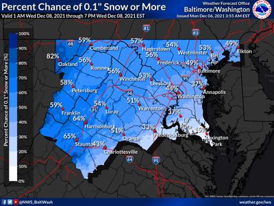
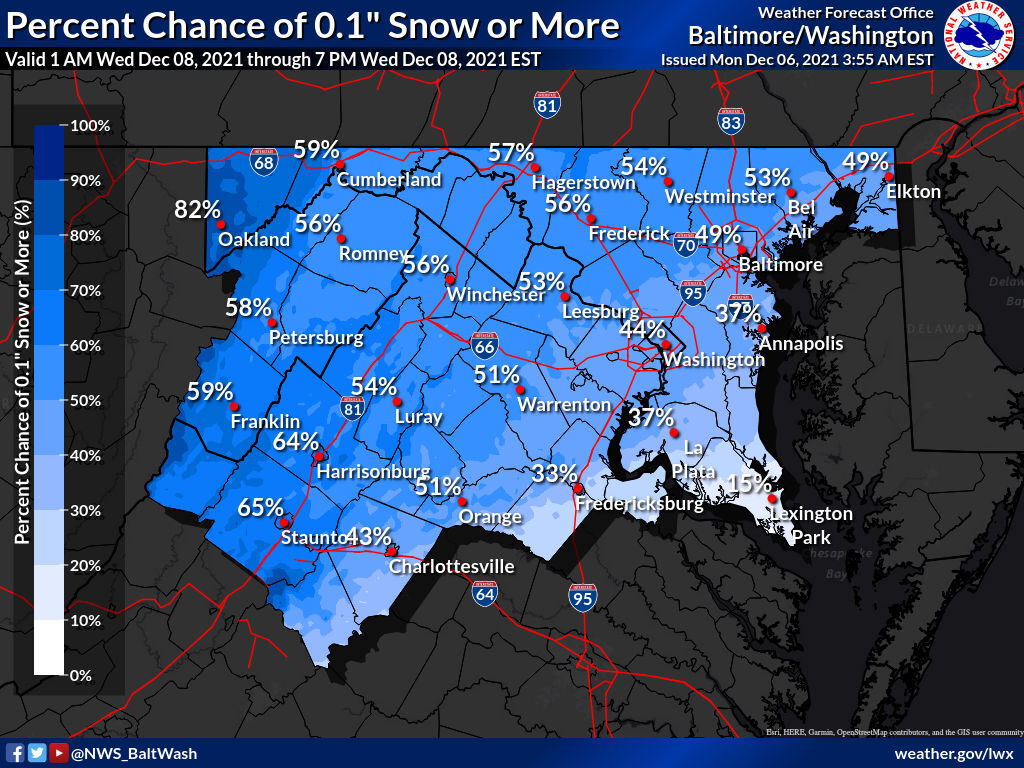
The the “fun” begins. The aforementioned cold front will stall along the Gulf Coast Tuesday, ripe for an upper-air disturbance to form a low pressure along it. That low pressure center will ride up the East Coast tomorrow night, bringing enough moisture with it to reform precipitation. Multiple numerical forecast models are aligning with the idea that enough cold air will be in place around Fredericksburg that frozen stuff is likely by dawn on Wednesday.
Thus Fredericksburg and Northern Neck residents can thus expect to see some flakes flying Wednesday morning. The graphic shows relatively low chances of any accumulation (the ground is still pretty warm, after all) but this may well be the first taste of true winter weather for the region. Precipitation will switch to all rain by mid-day as temperatures rise, but that’s good news as it’ll mean more moisture to help turn around the existing dryness.
Regardless of what form the precipitation takes, Wednesday will be a raw, cloudy day with afternoon temperatures topping out in the low 40s. It’ll be the coolest day of this week since things will warm back into the 60s by the weekend.