


Warmer conditions returning ahead of Thanksgiving
MACON, Georgia. (41NBC/WMGT) – After a strong cold front left wintry chills around Middle GA on Tuesday, warmer conditions are returning heading into Midweek.
Today
This morning was the coldest morning in Georgia so far this fall. Everywhere in Middle GA fell below freezing at some point before sunrise this morning. There is a good chance that everywhere in the state north of here did as well. The good news is the frigid conditions are not going to last as temperatures should reach 50 degrees around the region by noon. High temperatures this afternoon will be returning to the lower 6os for most of the region as well. The winds, now having shifted to the east-southeast, will be a lot calmer than yesterday. However with a bit of southerly flow now added extra moisture is being added to the atmosphere, allowing for more cloud development. Our clouds this afternoon, however, should be limited to a few cirrus clouds overhead. More cloud cover will fill in overnight as the wind shifts to the southeast. Low temperatures will remain chilly, but the southeast winds and bit of clouds should allow most locations to have lows back at and above freezing.
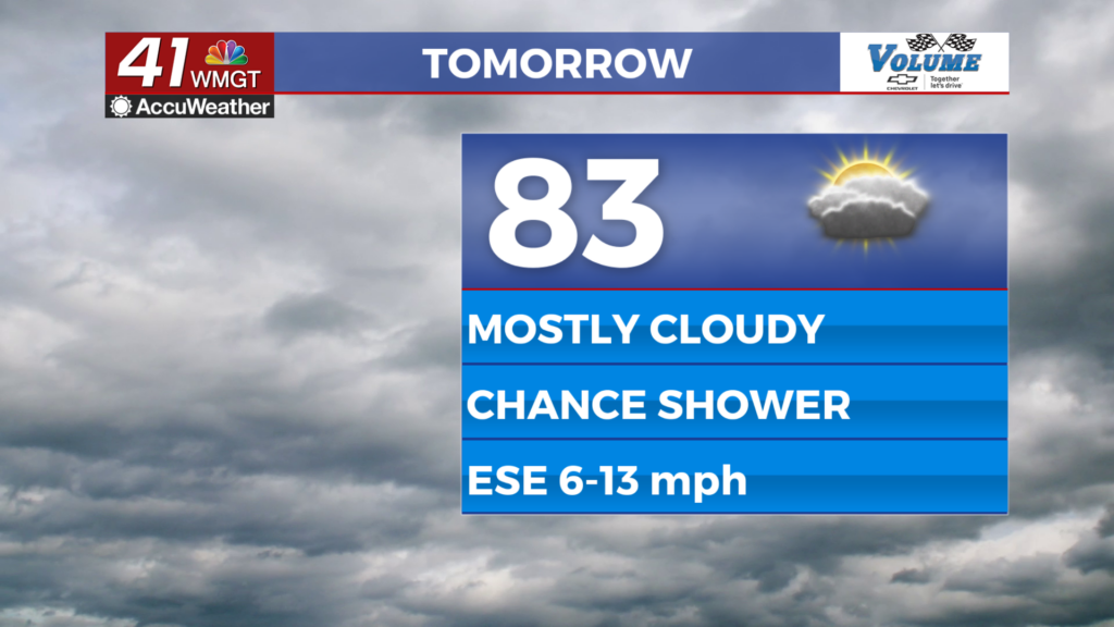
Thanksgiving
After another cold morning warmer conditions will quickly return. The surface winds will shift to the southwest during the late morning hours, allowing warm and moist gulf air to move into the Georgia atmosphere. A mix of sun and clouds will stick around through the daylight hours with the majority of the clouds being cirrus clouds ahead of the next cold front. High temperatures will jump almost 10 degrees from Wednesday, reaching the upper 60s. A few select southern locations in the region could crack the 70 degree mark. The good news is that rain chances will hold off for the day, so there won’t be any issues with planning for inclement weather this Thanksgiving. The cold front will arrive overnight with rain arriving after midnight. The locations that are further south in Middle GA have a lesser chance of seeing rain as the storms are again expected to peter out as the front moves through. Overnight lows will jump 15+ degrees for many in Middle GA compared to Thursday morning thanks to an abundance of cloud cover and winds from the southwest, bottoming out in the upper 40s and lower 50s.
Friday and the Weekend
Much like Monday, Friday will begin with above average temperatures and an abundance of cloud cover. These will clear out as the day goes on thanks to a wind shift to the northwest around sunrise. These will be breezy winds as well with sustained speeds of 10-15 mph and gusts 20+ mph. High temperatures will drop about 10 degrees from Thanksgiving, topping off in the upper 50s and lower 60s. By the time sunset arrives, the Middle GA skies should be clear. Low temperatures overnight will fall back into the lower 30s with many locations reaching or falling below freezing.
Saturday and Sunday will see a mix of sun and clouds as the winds return to the west-southwest early on Saturday. Temperatures will return to the 60s across the region as well beginning Saturday afternoon. Following the cold front Friday morning, overall benign conditions look to stick around into next week. Sunday and Monday look to be breezy days, however, with each one seeing sustained speeds at approximately 10-15 mph. These winds will be out of the west-northwest (Sunday) and the northwest (Monday). Rain chances should hold off until late next week.

Follow Meteorologist Aaron Lowery on Facebook (Aaron Lowery 41NBC) and Twitter (@ALowWX) for weather updates throughout the day. Also, you can watch his forecasts Monday through Friday on 41NBC News at Daybreak (6-7 a.m.) and 41Today (11 a.m).


Leave a Reply