Clouds returning Thursday; rain chances low but still there
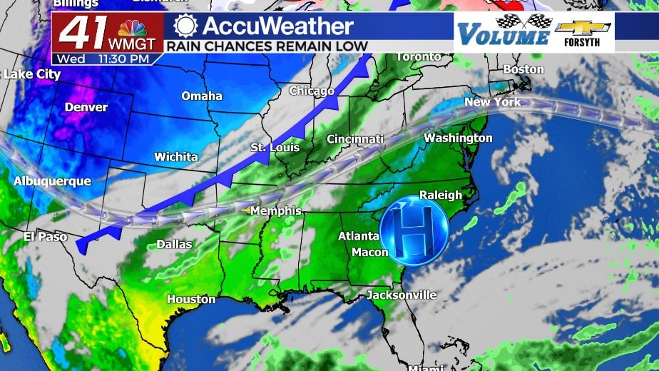
MACON, Georgia. (41NBC/WMGT) – The next cold front is arriving in Georgia Thursday, bringing clouds and some rain with it.
Tonight

Clear skies will persist through the rest of the evening and into the overnight hours. Continuous wind out of the southeast and south-southeast through the overnight hours will allow low temperatures to climb upwards of 10 degrees warmer than this morning, bottoming out in the upper 40s and lower 50s. Cloud cover will begin to fill in after midnight, also allowing for the warmer low temperatures by insulating the surface. When the morning arrives, however, there should still be opportunities to see the sunrise.
Tomorrow

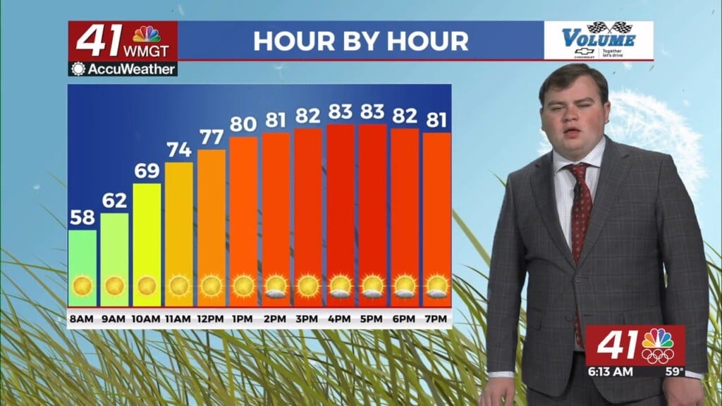
Cloud cover will continue to fill in through the morning hours, with high level clouds continuing to fill in from overnight and mid and low level clouds filling in ahead of lunchtime. The wind will also shift to the south-southwest and pickup in speed, hovering around 8-12 mph with gusts upwards of 20 mph. Temperatures will also be quite warm once again, with highs in Middle GA reaching the upper 70s and lower 80s. As for rain chances, a couple of spotty showers will be possible starting around lunchtime. Most locations will stay dry, and any rain will be light. During the late evening and early overnight hours, however, the cold front will move through. Most of the storms with it will have dissipated, but a couple of locations such as Forsyth, Roberta, and Macon could see an isolated thunderstorm.


Once the cold front passes the wind will quickly shift to the north-northwest at about 10-15 mph with gusts over 20 mph. Cloud cover will clear for the most part overnight, and temperatures will fall into the lower 40s, about 10 degrees cooler than Thursday morning. There shouldn’t be any rain overnight, however some clouds may still hang around into Friday morning. Rain totals from Thursday around Middle GA should also remain under a tenth of an inch (for those that do see rain).
Friday

Unlike the typical patterns we have seen so far this fall where the northwest wind persists the day after a cold front keeping things cool and clear, this Friday the wind will quickly shift to the northeast. It will be breezy too; 10-15 mph winds are likely with gusts in excess of 20 mph. Temperatures will be cooler however; similar to this past Monday the highs will be in the mid 60s for most locations in Middle GA. The skies will also not be completely clear; several high level clouds are likely to hang around with a few mid level clouds possible as well. Rain is not in the forecast for Friday, however; the next chance for that looks to be Sunday night.
The Weekend

Saturday will be similar to Friday albeit a bit cooler with highs in the lower 60s thanks to a persistent northeast wind. That wind, however, will shift to the east-northeast throughout the afternoon on Saturday. Less clouds are also expected than on Friday with skies remaining mostly clear into the overnight hours.

Sunday will see increasing clouds through the day with high temperatures returning to the upper 60s with winds shifting more southerly with an east-southeast flow. Mostly cloudy skies will stick around overnight with rain chances climbing into Monday morning.


Follow Meteorologist Aaron Lowery on Facebook (Aaron Lowery 41NBC) and Twitter (@ALowWX) for weather updates throughout the day. Also, you can watch his forecasts Monday through Friday on 41NBC News at Daybreak (6-7 a.m.) and 41Today (11 a.m).


Leave a Reply