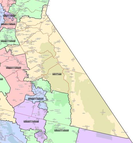
Tuolumne County could become part of a changed 4th Congressional District, according to new draft maps released Wednesday night for California’s congressional, state senate, state assembly, and state board of equalization districts.
The latest draft maps released by the California Citizens Redistricting Commission shows a geographically larger 4th District, subtracting parts of Nevada and Placer counties to the north, adding sections of Stanislaus and Madera counties to the west, subtracting part of Fresno County on the south, and adding Mono and Inyo counties on the eastside Sierra Nevada.
The Mother Lode’s congressman, U.S. Rep. Tom McClintock, R-Elk Grove, would continue representing Tuolumne County and the rest of the 4th Congressional District. An earlier suggestion from the redistricting commission had Tuolumne County joining the state’s 23rd Congressional District, represented by U.S. Rep. Kevin McCarthy, R-Bakersfield, the House minority leader.
The redistricting commission is comprised of 14 appointed volunteers — five Republicans, five Democrats, and four not affiliated with either of those two parties. Final maps are expected to be completed and certified by Dec. 27, Trena Turner, the commission chair, said in a statement.
“There is still plenty of time for the public to get involved,” Turner said. “We urge you to join us.”
Public comments are supposed to be taken for at least 14 days from the date of public display of the first preliminary statewide draft maps. The commission is not supposed to display any other maps for public comment during the 14-day period.
This is the commission’s draft map public input meeting schedule:
Nov. 17 — Congressional District Feedback
Nov. 18 — Assembly District Feedback
Nov. 19 — Senate District Feedback
Nov. 20 — Board of Equalization & Any District Feedback
Nov. 22 — Any District Feedback
Nov. 23 — Any District Feedback
Redistricting happens every 10 years and is based on population information gathered each decade for the national census. It’s always controversial because mapping and remapping physical areas where people live and vote can tip a given geographic area toward one political group and away from competing political groups.
Following criteria set out in the state constitution, the commission has tried to draw district maps that:
• Update all districts to be of equal population, to comply with the U.S. Constitution.
• Comply with the Voting Rights Act, to ensure minorities have equal opportunities to elect representatives of their choice.
• Update districts contiguously, so that all parts of the district are connected to each other.
• Minimize divisions of cities, counties, neighborhoods and communities of interest, if possible.
• Update districts to be geographically compact, so nearby areas of population are not bypassed for a more distant population. This requirement refers to density, not shape. Census blocks cannot be split.
Every 10 years, after the federal government publishes updated census information, California must redraw the boundaries of its electoral districts so that the state’s population is evenly allocated among the new districts.
In 2008, California voters passed the Voters First Act, authorizing creation of the independent California Citizens Redistricting Commission to draw new state senate, state assembly, and state board of equalization district lines. In 2010, the Voters First Act for Congress gave the commission responsibility for drawing new congressional districts following every census.
The draft maps released Wednesday night came out ahead of a state Supreme Court mandated Nov. 15 deadline.