
At a Glance
- A bomb cyclone triggered flooding rain and debris flows to California on Sunday and Monday.
- Its rainfall smashed all-time record in three California cities.
- It was the most intense known storm in this part of the Pacific Ocean, by pressure.
- It also brought over a foot of heavy snow to the Sierra.
What became the strongest known northeast Pacific bomb cyclone on record stunned drought-suffering California with record-smashing rain that triggered flooding and debris flows.
By far the wettest in a series of Pacific storms since last week, this powerful system dumped soaking rain over a prolonged period of time Sunday into Monday, tapping a long plume of moisture known as an atmospheric river, notorious for heavy rain events along the West Coast and elsewhere.
In several locations, Sunday's deluge was an all-time record-setter.
Sacramento set an all-time calendar-day rainfall record with 5.44 inches falling there on Sunday. This beat the city's previous calendar-day record of 5.28 inches set on April 20, 1880 in records dating to 1849.
Incredibly, the previous Sunday, the city had just snapped its record 212-day dry streak, seeing its first measurable rain since mid-March.

Blue Canyon (10.40 inches) and Santa Rosa (7.83 inches) also had their wettest single day on record, Sunday.
San Francisco had its wettest October day on record - 4.02 inches - and fourth wettest single day since 1849. Sunday's soaking was over four times its average for the entire month of October.
It wasn't simply the rainfall amount that was astounding, but how long it lasted.
"It is very rare that it ever rains for more than six consecutive hours around here," wrote Christopher Burt, weather historian and resident of the East Bay area to the east of San Francisco.
Burt told weather.com it rained for 34 straight hours through 6 a.m. PDT Monday.
Parts of Northern California, mainly on windward slopes of the Sierra or coastal ranges below snow level, picked up over a foot of rain from Saturday through Monday. Over 16 inches of rain was measured atop Mt. Tamalpais in Marin County, just north of the Golden Gate.
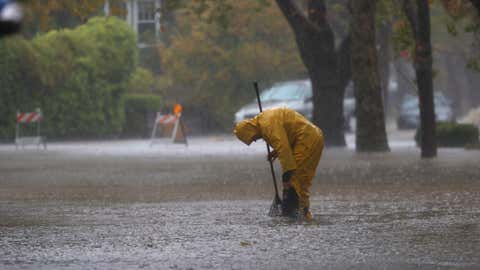
Flooding, debris flows and downed trees were reported in multiple locations in California on Sunday and Monday, particularly in the Sierra, and also from San Rafael and Santa Rosa through the Bay Area to the Salinas Valley. There were 87 reports of flooding or debris flows relayed to National Weather Service offices in California Sunday and Monday.
The record rain wasn't just in California.
Reno, Nevada, also set an October rainfall record with almost 3 inches of rain through Monday morning. Winnemucca, Nevada, picked up just over 2 inches of rain from the storm, more than a typical October and November, combined.
At elevations cold enough for snow, over 2 feet of heavy, wet snow was reported in the Sierra, which snarled travel over passes on Interstate 80 and other routes.
A Bomb Cyclone For the Record Books
The storm that tapped the atmospheric river broke a record of its own.
The area of low pressure associated easily became a bomb cyclone in the northeast Pacific Ocean over the weekend. Its pressure dropped to 942.5 millibars on Sunday off the Northwest U.S. coast, which is the lowest known pressure for a storm in this region of the Pacific dating to 1974.
In fact, it became the second bomb cyclone in a week's time in that part of the northeastern Pacific Ocean.
A bomb cyclone is a term meteorologists use for a low-pressure system associated with fronts whose central pressure plunges at least 24 millibars in 24 hours or less.
Some of the bomb cyclone's strong winds blasted parts of California and the West Coast.
A 159-mph gust was clocked at the summit of Mammoth Mountain. One gust to 82 mph was measured on the Yaquina Bay Bridge near Newport, Oregon, and a 74 mph gust blasted Cape Disappointment, Washington.
Winds up to 60 mph were clocked at San Francisco International Airport.
Using an index combining rainfall, sustained winds and peak gusts, Golden Gate Weather Services meteorologist Jan Null said this tied for the third strongest storm to hit the Bay Area since 1950.
Snuffing Out Wildfire Threat For a While
Considering that hot, dry Santa Ana and Diablo winds can ignite and spread wildfires this time of year, this storm may have been the lesser of two evils.
While clearly it was too much of a good thing as far as the extremity of precipitation triggering flooding and debris flows, this storm at least certainly lowered what can often be a significant fall wildfire risk and dampened existing wildfires.
(MORE: What's Next For California's Drought)

It also sent reservoir levels skyrocketing.
Lake Oroville, one key reservoir located in Butte County, rose over 23 feet after the deluge, but still remained about 80 feet lower than in late October 2020.

The Weather Company’s primary journalistic mission is to report on breaking weather news, the environment and the importance of science to our lives. This story does not necessarily represent the position of our parent company, IBM.


