How should North County fit in new San Diego County supervisor district boundaries?
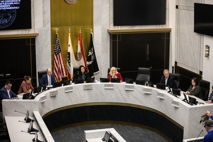
The San Diego County Independent Redistricting Commission looked at four dramatically different district maps last week, as it considered various scenarios to update county supervisory boundaries.
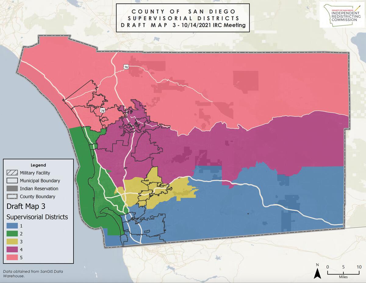
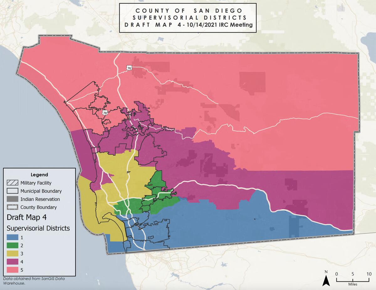
The maps, produced by the demographer FLO Analytics, show major overhauls to current district lines, with options ranging from a horizontal scheme where each district extends east to west, to others that include a linear coastal district from Coronado to Encinitas.
At the Thursday meeting, commissioners focused on the challenge of keeping North County communities in one supervisorial district, as they approach a December deadline to submit a redistricting plan.
Because of shifting demographics over the past decade, San Diego County must adjust boundaries to maintain “reasonably equal population” in each district to comply with the Voting Rights Act. The commission has to balance the number of constituents in each district while avoiding dividing cities, neighborhoods and “communities of interest,” which include areas with common geographic, economic or cultural interests.
That can pose a tricky equation for North County, which includes about a third of the county’s population, spread out across residential and rural communities along state Route 78 and in the northern backcountry along Interstate 15.
Under the current boundaries, the city of Escondido is included with Encinitas, Del Mar, Solana Beach and Miramar in District 2, represented by Supervisor Terra Lawson-Remer.
Although members of the public had been vocal about their preference for keeping North County together, only one of the four draft maps grouped Escondido with the cities of San Marcos, Vista, Oceanside and Carlsbad. That map, however, excluded backcountry communities of Fallbrook, Bonsall and Valley Center, which also identify as part of North County.
“I feel that Escondido is very much a linchpin of the eastern terminal of the (State Route) 78 corridor,” said Commissioner Jack Russ. “But I also realize that you cannot have Escondido, Carlsbad and all the areas in the northeast quadrant.”
Members of the public similarly requested a North County district that would support the region’s shared interest in preserving agriculture, fighting wildfire and ensuring political representation for its large Latino population.
“Fallbrook, Escondido, Oceanside (and the other) communities all grew up together for the past 120 years,” said Tom Frew, a volunteer historian with the Fallbrook Historical Society. “I urge you to try a little harder. I think we can improve on these.”
Escondido resident Lilian Serrano urged the commission to move Carlsbad to a potential coastal district, to pull Escondido into a northern district.
“Yesterday when I saw the draft maps I was personally disappointed, because I don’t think any of the draft maps reflect my community of interest and don’t protect Latino voting blocks in North County,” Serrano said. “We share a lot: the same community clinics, grocery stores, street fairs. I’m asking you to drop Carlsbad from District 5, to include as much as possible of unincorporated areas of Fallbrook and Valley Center.”
Some commissioners said they were reluctant to exclude Carlsbad from a North County district, noting that other constituents had previously voiced a desire to keep Carlsbad Airport within that boundary.
The drafts presented Thursday mark a starting point. They will be updated through a series of meetings and public hearings leading to the adoption of final district maps on Dec. 15.
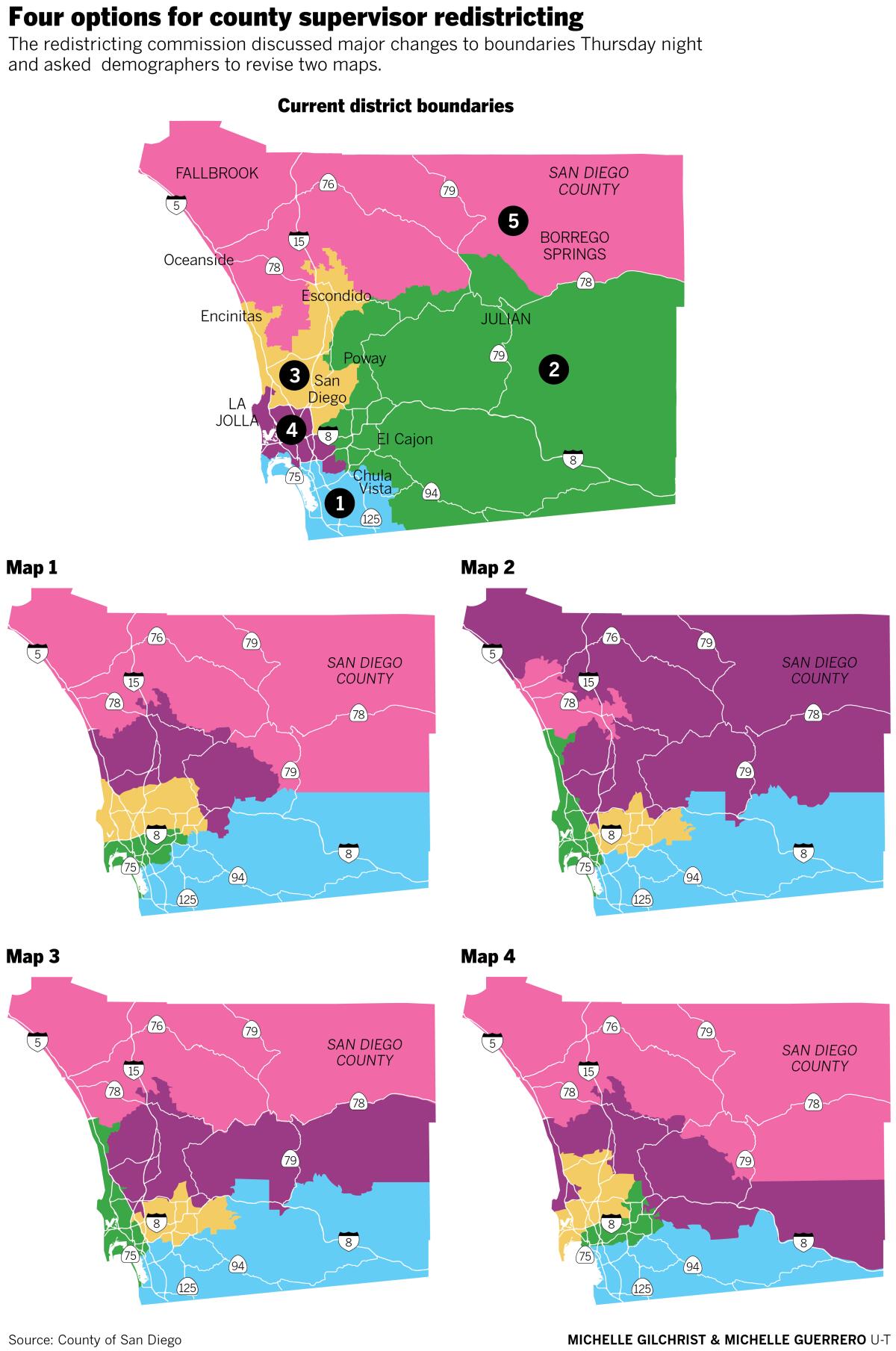
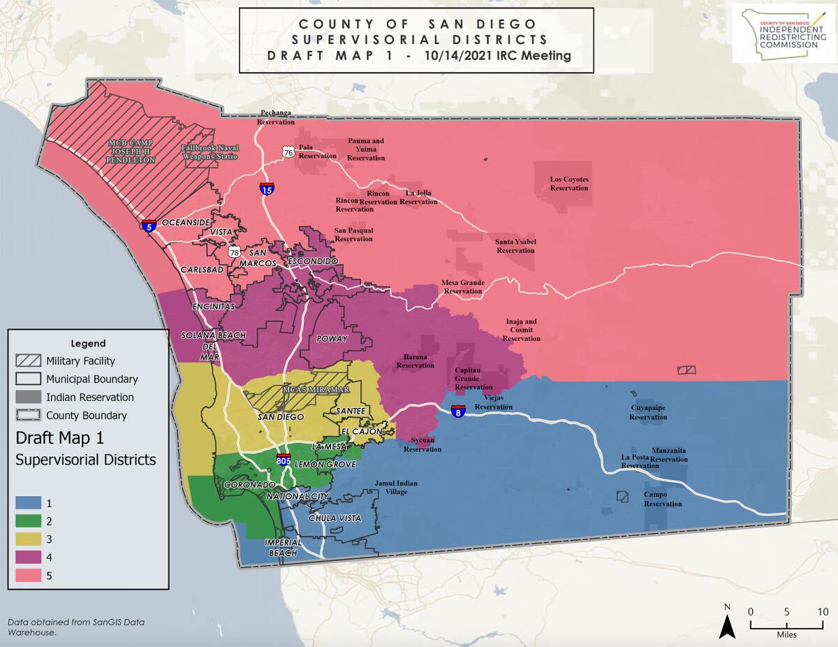
Draft map 1 depicts horizontal districts stretching east-west from the coast inland. Under that scenario, District 5, represented now by Supervisor Jim Desmond, would include a large swath of unincorporated backcountry and all North County cities except Escondido.
District 4, overseen by Board of Supervisors Chair Nathan Fletcher, would start at Encinitas and Solana Beach, and continue through Poway into part of the back country.
District 3, now served byLawson-Remer, would cover much of the central San Diego coast and include central San Diego, Santee and El Cajon.
District 2, covered by Supervisor Joel Anderson, now includes much of unincorporated East County. Under draft map 1 it would encompass Coronado, Lemon Grove and La Mesa, but stop short of backcountry areas.
District 1, represented by Supervisor Nora Vargas, would extend across the border from Imperial Beach to the county line.
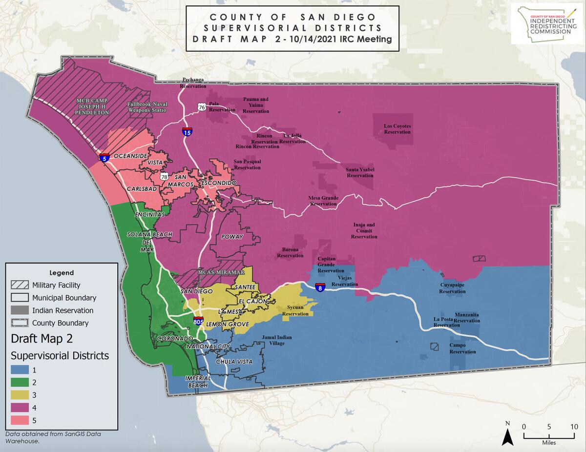
The next draft map replaces District 5 with District 4 for the county’s northern area, creating a sprawling jurisdiction that covers nearly all the county’s backcountry, along with central San Diego and Poway.
District 5 would include the North County cities of Carlsbad, Oceanside, San Marcos, Vista and Escondido.
District 3 would cover an inland area with part of the city of San Diego as well as Santee, El Cajon, La Mesa and Lemon Grove.
As in draft map 1, District 1 would extend across the border from the beaches to the backcountry.
The third draft map presents a variation on that scenario, with District 5 continuing to include nearly all unincorporated land in the north, and all North County cities except Escondido, which would be part of District 4.
Under draft map 4, Districts 2 and 3 would be reversed, with District 2 covering the inland cities of Santee, El Cajon, La Mesa and Lemon Grove and District 3 including the city of San Diego and portions of the coast.
A number of commissioners and speakers said they favored draft maps 2 and 3 over the others.
The commission directed FLO Analytics to return with modified versions of those two maps but with different scenarios for configuring a North County district. It will consider the modified versions of draft maps 2 and 3 at a public hearing on Nov. 1.
This is the first time San Diego has tasked an independent commission with drawing its boundaries, although the state of California launched a similar process in 2010.
San Diego County has seen a 6.6 percent population increase over the past decade, according to the census, with the addition of 203,301 residents. But some districts experienced more growth than others. No district in San Diego County showed a decline in population.
District 3, represented by Lawson-Remer, saw the largest change, with an increase of 8.6 percent. That’s followed by District 5, where Desmond’s area grew by 7.5 percent.
District 4, represented by Fletcher, grew the least, by 4.9 percent.
Supervisor redistricting proposals
Map 1
Map 2
Map 3
Map 4
Get the RSF Review weekly in your inbox
Latest news from Rancho Santa Fe every Thursday for free
You may occasionally receive promotional content from the Rancho Santa Fe Review.

