At a Glance
- Several roads were shut down.
- Evacuations were ordered in some areas.
- Hundreds of thousands of power outages were reported.
Evacuations were ordered, roads were closed and hundreds of thousands of people were without electricity Sunday night as a powerful storm roared across parts of California and the Pacific Northwest.
The weather brought the threat of potentially deadly landslides and flooding.
The risk is particularly high in terrain left barren by wildfires, which is vulnerable to flooding and an especially dangerous and fast-moving type of landslide that scientists call "debris flows."
Watches and warnings for flooding and debris flow were issued ahead of the storm for areas including the Dixie and Alisal burn scar areas.
(FORECAST: Powerhouse Atmospheric River Storm Arrives in California)
The weather is bringing relief amid a historic drought and tamping down the threat of fall wildfires. But it remains to be seen how the region's wet season will play out.
Here's a look at what happened throughout the day and evening Sunday.
400,000+ Power Outages in California, Oregon, Washington
Nearly 400,000 power outages were reported across three states, according to poweroutage.us. More than 179,000 were in Washington, with many of them due to high winds in King County around Seattle.
About 175,000 homes and businesses were without electricity in California. Outages were especially prevalent in northern coastal counties including Sonoma, Marin and San Mateo. Others were concentrated in Butte and Nevada counties.
There were about 28,000 outages in Oregon, mainly in the northwest corner of the state.
Evacuations Due to Flooding in Sonoma County
Residents in one Santa Rosa neighborhood were told to leave due to flooding. Firefighters went door to door in water rescue gear and an apartment complex was evacuated, the San Francisco Chronicle reported.
Resident Todd Everett, 61, told the newspaper a usually “sleepy neighborhood creek” turned into “a roaring river.” Everett said he and his family moved to the area 3 years ago from Chicago.
“We escaped the blizzards of Chicago only to face the monstrous rains in the middle of the drought,” he said.
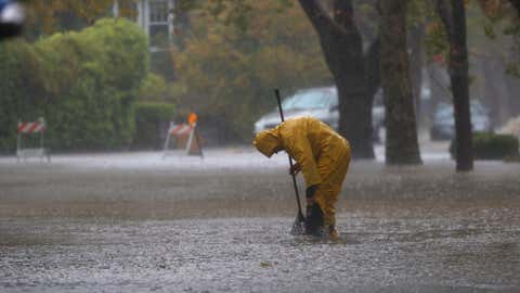
Two Feet of Water Reported Over City Streets
Police in San Rafael sent an alert to residents Sunday afternoon warning of extreme flooding in the city's downtown corridor.
"Many of the roadways are under 2 feet of water and are impassable or otherwise closed," the alert said. "The flooding is anticipated to worsen due to another high tide, in addition to the rain fall levels from the 'atmospheric river.'"
The city sits on the bay north of San Francisco.
Evacuations Ordered in Fresno County
People in the Fresno County section of the Creek Fire burn scar area were also told to evacuate their homes.
The affected area included Big Creek Canyon from below Big Creek to the San Joaquin River, according to the county sheriff's department.
The Creek Fire burned in Fresno County and neighboring Madera County in 2020.
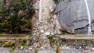
Multiple Landslides Reported
Several landslides happened, including one that shut down Highway 70 near Tobin in Plumas County, where the Dixie Fire left behind large swaths of burn scars.
"Numerous mud, rock and debris flows have been reported," the National Weather Service in Reno tweeted. "This event is just getting underway! Stay alert and stay safe today!"
A photo posted to social media showed rocks covering Highway 70.
The Dixie Fire is the single largest wildfire in California history and tore through nearly 1 million acres, or about 1,500 square miles. The blaze started July 13 and burned in Butte, Lassen, Plumas, Shasta and Tehama counties.
100-Foot-Tall Tree Prompts Evacuations in San Francisco
First responders went door to door to warn residents near a 100-foot-tall that was in danger of falling over, according to the city fire department.
Occupants of at least three buildings were told to evacuate.
There were numerous instances of downed power lines and trees blocking roads around the city.
Multiple Reports of Downed Trees
Firefighters in San Mateo County, south of San Francisco, responded to dozens of storm-related calls including downed trees and power lines.
Evacuations Ordered in Alisal Burn Scar Area
An evacuation was ordered for some residents in the Alisal Fire burn scar area, including areas west of Las Flores Canyon, east of Mariposa Reina, south of West Camino Cielo, and down to the ocean. A warning was issued on Saturday and later upgraded.
The Alisal Fire started earlier this month and burned more than 26 square miles in Santa Barbara County.
Evacuations were also issued in other areas including Santa Cruz County, where a shelter is open at San Lorenzo Valley High School. Areas there were burned last year by the CZU Lightning Complex Fire.
It May Be Too Late For Some to Leave, NWS Warns
The National Weather Service in Sacramento said debris flows were already occurring Sunday morning. In a tweet, the agency warned residents that time may have already run out for some to leave.
"If you are near a burn scar, it may be too late to evacuate," the agency said in a tweet. "Do not attempt to cross a debris flow. Take shelter in the highest floor of your home."
Warning signs of an impending debris flow include rushing water and mud as well as unusual sounds like cracking, breaking, roaring or the sound of a freight train.
What's Causing This Weather?
The rain is from a powerhouse storm tapping into a strong atmospheric river that moved into California Sunday.
Soaking rain from this latest storm to hit the West Coast is ongoing right now from Northern California into the Pacific Northwest.
Heavy snow is also possible in some areas.
Click here for the full forecast.
What Are Debris Flows and Why Are They So Dangerous?
Terrain left barren by wildfires is most vulnerable to an especially dangerous and fast-moving type of landslide that scientists call "debris flows." Known less formally as mudslides, these flows are typically triggered by short, intense rainstorms and can send a wall of water, soil, ash, vegetation, rocks and other debris careening downhill, sweeping away or burying everything in its path.
"A debris flow is kind of a flood on steroids," Jason Kean, a debris flow expert with the U.S. Geological Survey, told weather.com in an interview. "It’s all bulked up with rocks, mud, even boulders – and boulders can be the size of cars."
Besides destroying vegetation that would normally hold soil and debris in place, wildfires change certain characteristics of the soil itself. It becomes less likely to absorb water, which creates conditions ripe for flash flooding and debris flows
Click here to learn more.

The Weather Company’s primary journalistic mission is to report on breaking weather news, the environment and the importance of science to our lives. This story does not necessarily represent the position of our parent company, IBM.


