
At a Glance
- Barren, charred landscapes are vulnerable to dangerous debris flows.
- Parts of California and Oregon are threatened through next week.
- The risk ramps up as the rainy season kicks into high gear.
A newer version of this article appears here.
California is bracing for dangerous and potentially deadly landslides in the coming days, as much-needed rain moves in amid historic drought conditions.
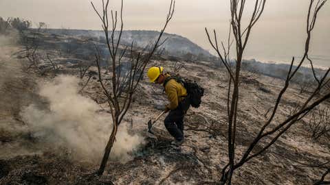
Terrain left barren by wildfires is most vulnerable to an especially dangerous and fast-moving type of landslide that scientists call "debris flows." Known less formally as mudslides, these flows are typically triggered by short, intense rainstorms and can send a wall of water, soil, ash, vegetation, rocks and other debris careening downhill, sweeping away or burying everything in its path.
"A debris flow is kind of a flood on steroids," Jason Kean, a debris flow expert with the U.S. Geological Survey, told weather.com in an interview. "It’s all bulked up with rocks, mud, even boulders – and boulders can be the size of cars."
(MORE: Latest Forecast for Western Storms)
The threat of landslides usually increases in the fall as wetter weather typically starts to move across the West Coast. A parade of storms forecast into next week has parts of both California and Oregon on alert for debris flows.
The USGS and other agencies work together to assess the debris flow threat in burn scars each year. So far they've completed assessments for about 60 fires in nine western states. The public can read them here.
Among the areas of highest concern in California this year are the Dixie, Monument and Alisal fire burn footprints, Jaime Kostelnik, also a geologist on the assessment team, told weather.com in a recent interview.
In Oregon, areas with high risk include parts of the Devils Knob, Jack and Bootleg burn areas.
But any burn scar can potentially be at risk, and conditions can change over time depending on the weather and other factors.
The cumulative effects of extreme wildfires in recent years make the situation even more hazardous, especially in California. Many of the areas impacted by wildfires have burned more than once in recent years.
Besides destroying vegetation that would normally hold soil and debris in place, wildfires change certain characteristics of the soil itself. It becomes less likely to absorb water, which creates conditions ripe for flash flooding and debris flows, according to Kean and Kostelnik.
"As (the water) runs off, it picks up all these loose soil particles that no longer have vegetation to hold them in place and then it bulks up into that debris flow that can move really fast and start actually within minutes of intense rainfall," said Kean.
Debris can rush down a hillside at a rate over 35 mph and then flatten out and spread even farther when it reaches the bottom of a slope.
At least 20 people were killed when mudslides with walls of debris as tall as 30 feet struck the Santa Barbara County community of Montecito in 2018. On average, 25 to 50 people are killed by landslides every year in the United States, according to the USGS.
This week, emergency crews worked to prepare areas scarred by the Alisal Fire before the wet weather moved in. That included installing barriers to keep mud and debris from washing over roadways, the Santa Barbara News-Press reported.
Storm prep was also underway along the Caldor Fire burn scar in Sacramento, where work included placing fallen trees across bulldozer lines to hold soil in place.
“The heavy predicted rains this week has us concerned, but we're going to keep working as long as we can,” Paul Naman, a service repair supervisor at the site, told KOVR-TV.
The elevated risk of debris flows in a burn scar can last up to five years after a fire. Officials in Santa Cruz County, for example, are warning people who live in the area of the 2018 CZU Complex Fire to be on alert for debris flow danger.
The threat for California as a whole will increase as the rainy season moves in, usually at its peak from November through February.
"California has a distinct wet season that lasts from late fall into early spring, and a dry season with little to no rainfall from late spring to early fall," said weather.com meteorologist Chris Dolce. "That extreme variance is related to an area of high pressure that sets up off the West Coast in summer and prevents any significant moisture from reaching the state. Conversely, in winter, that high weakens and shifts farther south, which opens the door for Pacific storms to affect California with heavy rain and mountain snow."
The state is in the clutches of a historic two-year drought. While the rain in the coming days will bring some relief, it remains to be seen how wet this year's winter will be. And experts say it could take years to catch up from the precipitation deficit.
Wildfire danger, meanwhile, peaks in the fall because that's when vegetation is completely dried out prior to the arrival of the first significant Pacific storms of the season, Dolce said.
Research has linked California's progressively more extreme fire seasons to climate change, and a study published last year by the University of California Institute of Transportation Studies found that the risk of post-wildfire debris flows is also likely to go up.
Experts say people in areas under threat should be alert if any rain develops, and don't wait for an evacuation order to leave if heavy rains develop.
"They should take it seriously," Kostelnik said.
The Weather Company’s primary journalistic mission is to report on breaking weather news, the environment and the importance of science to our lives. This story does not necessarily represent the position of our parent company, IBM.


