How to find eco-friendly routes and EV charging stops in Google Maps
Every Earth Day, Google adds new sustainability features for eco-friendly travelers. These are the tools you need to know about.
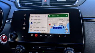
Every Earth Day, Google Maps gets new "sustainability" tools, from a default eco-friendly route setting to better tools for finding EV charging stations. With Earth Day 2024 rolling around, we're once again highlighting all of the Google Maps tools for eco-friendly directions for road trips, flights, trains, and more.
Why does this matter? Back in 2022, Google estimated that its eco-friendly routing prevented "half a million metric tons of carbon emissions — the equivalent of taking 100,000 fuel-based cars off the road," and no doubt that number has jumped in the years since. Collectively, Google Maps users can have a serious impact by using its sustainability features.
From low-carbon alternative routes to real-time EV port availability, these are all the Google Maps eco-friendly tools you need to know about for Earth Day (and beyond).
How to find eco-friendly driving directions in Google Maps
1. Tap your Google account profile icon in Google Maps.
2. Select Settings.
3. Scroll down to find Navigation Settings.
4. Under Route options, toggle Prefer fuel-efficient routes on. This will suggest these routes by default "when arrival times are similar."
Be an expert in 5 minutes
Get the latest news from Android Central, your trusted companion in the world of Android
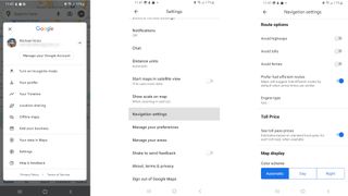
To specifically enable a fuel-efficient route for one trip:
1. Search for any destination in the Google Maps app.
2. At the bottom left, select Directions.
3. Enter your start location.
4. At the top right, select ... More.
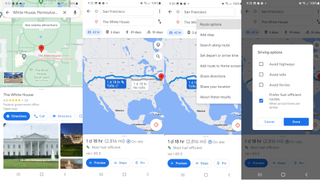
5. Select Route options.
6. Select Prefer fuel-efficient routes.
7. Select Done.
Once you trigger this option, hitting Directions will typically show a green leaf symbol and the promise that it is the "Most fuel-efficient" route available. Swipe up to show more information, and it'll say "Uses X% less fuel than alternate routes," using the following criteria:
- Average fuel or energy consumption for vehicles in your region
- Steepness of hills on your route
- Stop-and-go traffic patterns
- Types of roads, such as local roads or highways
If you decide that speed is more important for a trip than fuel economy, then simply re-follow the steps above and uncheck "Prefer fuel-efficient routes" to change back your results.
How to adjust Google Maps routes for electric or hybrid cars
Google Maps can actually take your type of vehicle into account for directions, which is especially useful if you need to know where the nearest charging station is for an efficient route.
1. Go back to Profile > Settings > Navigation Settings > Route Options.
2. Tap Engine type and choose Gas, Diesel, Electric, or Hybrid.
3. If you own an electric or hybrid car, go back into Settings and select Electric vehicle settings.
4. Tap Add plugs and enter which type your car needs. This way, when you search for nearby charging stations during your drive, Maps will take this into account.
Once this is set up, Google Maps will help electric car drivers on long trips to find "the best stop based on factors like current traffic, your charge level and expected energy consumption."
Also, when you search for nearby stations, you can filter the results by tapping Fast Charge above the map, so they only show stations that hit "150 kilowatts or higher," so you don't have to wait for long to get moving.
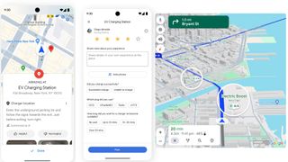
For Earth Day 2024, Google announced upcoming Maps features for EV drivers, shown in the screenshots above.
First, Google intends to use "AI-powered summaries in Google Maps that describe a charger’s specific location based on helpful information from user reviews," so it's easier to figure out where to go after you "arrive at your destination." It's part of their recent Google Gemini AI push.
On that note, Google Maps will now add new criteria to EV reviews, letting you describe which plug type you used, whether you successfully charged, and how long of a wait there was.
Google will use this data to populate the main map with nearby chargers and estimates for how long of a wait you'll face. This feature will arrive globally "in the coming months." Plus, it intends to add the nearest EV stops for people planning multi-stop trips.
How to find bike-share and scooter-share options in Google Maps
1. Search for your destination and select Directions.
2. Enter your start location.
3. Select the Cycling tab.
4. On the display bottom, you'll see the time it would take on Your bike. To that tab's right, you may see other bike-share or scooter-share options. Select another tab to see your options.
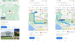
Partnered services will appear on the map, showing how many bikes are available at the nearest location. You'll also see approximate walking times to the nearest available bike, cycling distance to the nearest parking spot, and walk time from that spot to your final destination. And if the service has its own Android or iOS app, you'll see an Open app option to reserve your bike or scooter.
If, however, you don't see any other tabs, that means your city isn't currently supported by Google Maps, and you'll have to rely on your own bike to get around.
How to find driving and flying alternatives in Google Maps
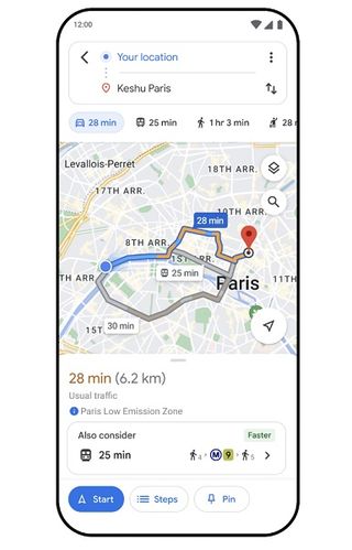
As part of Earth Day 2024, Google announced new Maps sustainability features, including one in select walkable cities worldwide that automatically shows public transit or walking directions when searching for driving directions.
It arrived on April 17 for Amsterdam, Barcelona, Brussels, Budapest, Cologne, Hamburg, London, Madrid, Melbourne, Milan, Montreal, Munich, Paris, Rome, Sydney, Vienna, and Zurich; we assume it'll arrive in other major cities soon.
As for flying alternatives, Google now automatically shows train alternatives when you search for flights since these will allow you to save on emissions for long-distance travel. If you're concerned about travel emissions, you can see how much carbon footprint your flight will have, then see if a train ride would be a better option.
Whether you're using Google Maps' eco-friendly driving directions on an Android phone or an iPhone, it's very easy to find this information by default. It's a nice change compared to other apps that either ignore this data or make you look for it.
If you're looking for other ways to change your habits for Earth Day, you can also use Google Maps to find eco-friendly businesses or recycling centers nearby. Or, you can look at sustainably made or repairable smartphones that'll lower your tech e-waste.

Michael is Android Central's resident expert on fitness tech and wearables, with an enthusiast's love of VR tech on the side. After years freelancing for Techradar, Wareable, Windows Central, Digital Trends, and other sites on a variety of tech topics, AC has given him the chance to really dive into the topics he's passionate about. He's also a semi-reformed Apple-to-Android user who loves D&D, Star Wars, and Lord of the Rings.
For wearables, Michael has tested dozens of smartwatches from Garmin, Fitbit, Samsung, Apple, COROS, Polar, Amazfit, and other brands, and will always focus on recommending the best product over the best brand. He's also completed marathons like NYC, SF, Marine Corps, Big Sur, and California International — though he's still trying to break that 4-hour barrier.
