How remnants of Hurricane Ida wreaked havoc on Northeast
Storms like these are clear indicators of climate change.
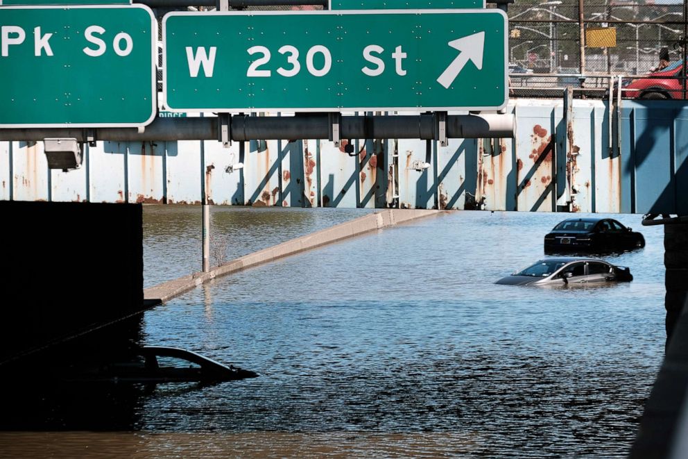
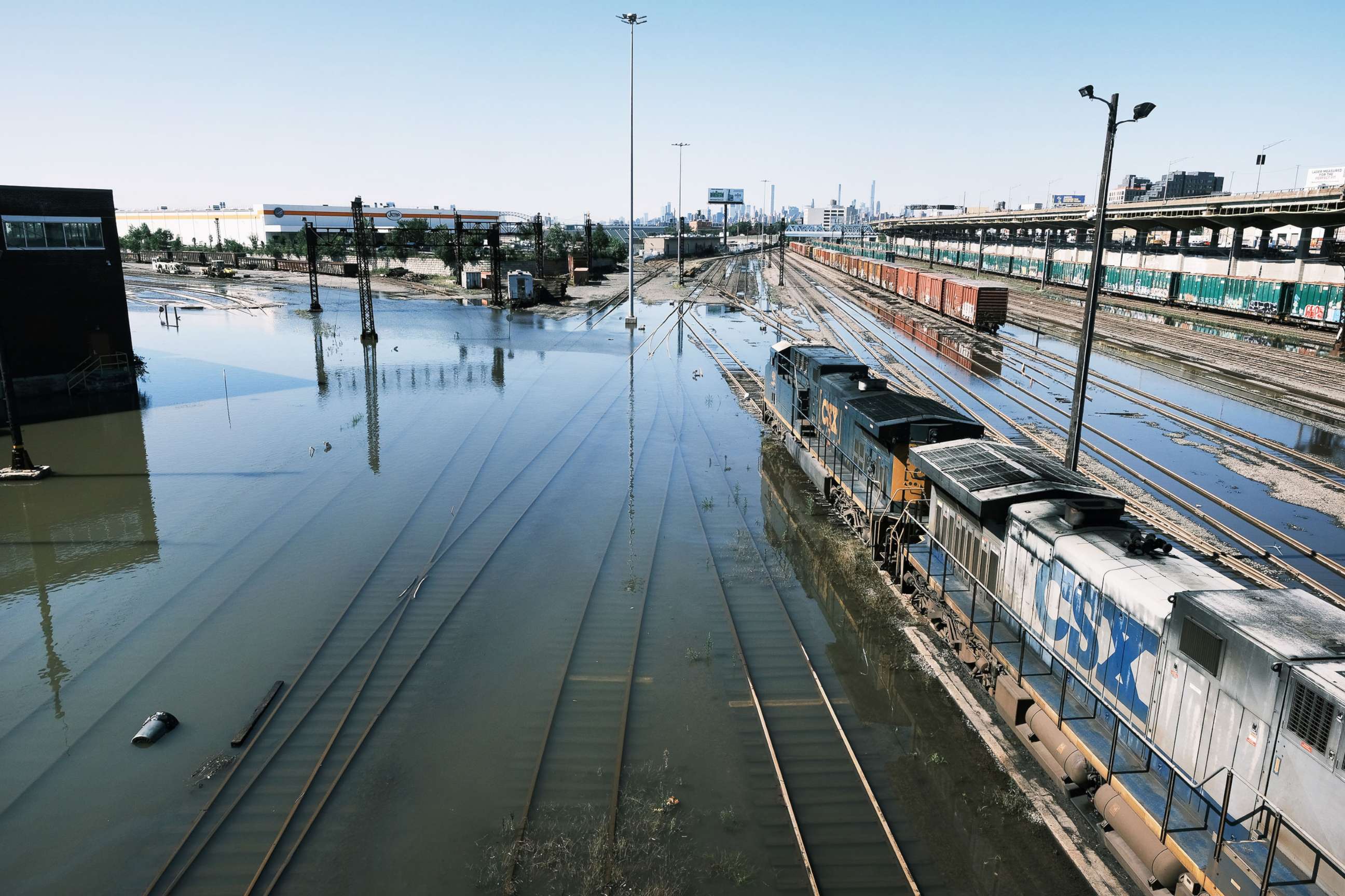
The remnants of Hurricane Ida brought a record-breaking deluge to the northeastern U.S. Wednesday.
The National Weather Service issued the first-ever flash flood emergency for New York City Wednesday evening while the city was walloped with 7.19 inches of rain. Over 3 inches of rain fell from 8:50 p.m. to 9:50 p.m., making it the wettest hour for the city on record. At least 45 people are dead in the Northeast due to the storm.
The amount of rain that fell in such a short amount of time made the storm unprecedented.
Parts of New York and New Jersey are coming off of their top three wettest summers on record, so the ground was already saturated with rainfall. New York City just broke rain records from Hurricane Henri less than two weeks ago.

Experts agree storms like these, which are being seen around the globe, are clear indicators of climate change. As temperatures warm, the amount of water vapor that the atmosphere can hold increases. This raises the ceiling on how much more intense extreme precipitation can become -- causing record-shattering rainfall.
"In reality, what was once the 100-year flood, the flood that had about a 1% chance of happening any given year, isn't the 100-year flood anymore," Daniel Swain, a climate scientist at the University of California, Los Angeles, told ABC News. He added that extreme precipitation and ensuing floods are not just taking place in North America, but also in Europe and southeast Asia as well.
"What's really becoming clear is ... the main reason for that is human-caused climate change, which is increasing the amount of water vapor in the atmosphere and raising the ceiling on how intense the precipitation is under a variety of meteorological conditions," Swain explained.
Across the Hudson River, in Newark, New Jersey, the city received its most rain in one day ever. Four people were found dead in one New Jersey apartment in the aftermath of the flooding Thursday morning.
While a storm's intensity always depends on the atmospheric dynamics in place, a typical post-tropical system may dump about 3 to 6 inches of rain as it hits the Northeast. Newark saw double that amount in one day -- 8.41 inches.
The historic storm the New York metro area saw Wednesday was a result of Ida's remnants interacting with a frontal system that helped it squeeze out the abundant tropical moisture still within Ida.
Parts of Connecticut and Rhode Island saw more than half a foot of rain Wednesday night. Flooding was reported in Boston early Thursday, as the storm finally moved off coast and exited the region later Thursday morning.
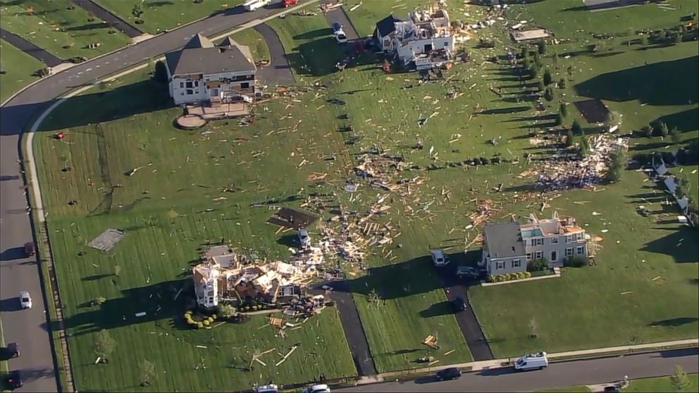
Tornadoes in the Northeast, heat advisory in the South
At least six tornadoes were reported across Maryland, New Jersey, Pennsylvania and Virginia in addition to the extreme flooding. In Annapolis, Maryland, roofs were ripped off homes and warehouses.
Tornadoes are normally rare in the Northeast because of topography and atmospheric conditions. Most tornadoes in the U.S. happen in the Great Plains, where the land is mostly flat.
The Northeast is abundant with hills and mountains that can disrupt the circulation and prevent tornadoes from forming. Also, atmospheric conditions are usually not extreme enough in the Northeast due to the moderating effects of nearby mild Atlantic Ocean and the Gulf Stream.
Tornado outbreaks happen when there's a collision of air masses with different temperatures. The greater the difference, the stronger the thunderstorm and therefore the bigger chance for tornadoes to happen.
As states across the South reel from the storm, heat advisories have been issued as many remain without power. The NWS in New Orleans lowered their criteria for this advisory for the area from 105 down to 100 degrees, because so many people aren't able to turn on air conditioning.
With high humidity in the region, the heat index is expected to surpass 105 degrees Thursday.
Hurricane season will peak in 1 week
The hurricane season doesn't peak until Sept. 10.
Hurricanes are intensifying more quickly and packing more moisture to deliver stronger hurricanes on land that drop more intense rainfall than we've ever seen.
Hurricane Ida was the fourth-fastest intensifying hurricane on record. In the last five years, the number of storms that undergo this type of rapid intensification have increased, including Hurricane Laura (2020), Michael (2018) and Harvey (2017).
This is in part due to conducive environmental conditions, including low wind shear, as well as well-above-normal sea-surface temperatures closer to the coasts, especially along the Gulf.
"As the climate continues to warm, we are going to see more ... precipitation events that shatter historical records and have impacts that are far greater than those that folks were accustomed to historically," Swain said. "In addition to being the summer of the flood ... it's also the summer of fire in other places and the summer of incredible, unprecedented, record-shattering heat in other places -- so there's a whole range of extreme weather events that we're seeing this year, many of which have really strong links to climate change."
There are currently two other systems in the Atlantic, including Hurricane Larry, which is currently a Category 1 hurricane with winds of 75 mph. It's forecasted to build in the Atlantic Ocean off Puerto Rico and become a Category 4 hurricane with winds of 130 mph in the coming days as it turns through the empty ocean.
Larry is not expected to threaten the U.S. or any landmass in the Atlantic; for now, it is called a "fish storm."
Related Topics
