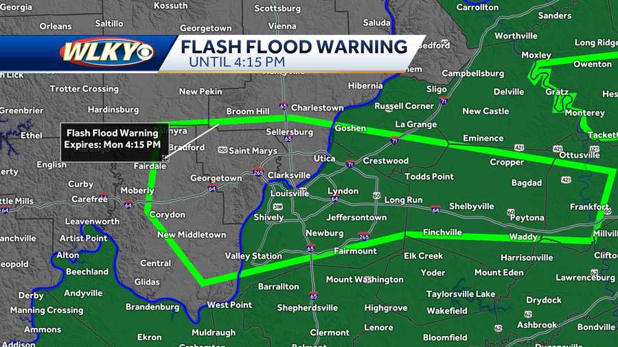
HEAVY RAIN IMPACTS: Flash flood warning until 4:15 p.m. in Louisville region
Heavy soaking rains are expected to bring some possible flooding concerns to our area.
Heavy soaking rains are expected to bring some possible flooding concerns to our area.
Soaking showers and torrential downpours will be heading into the viewing area over the next few days. A flash flood watch will go into effect Tuesday morning, continuing through Wednesday morning.
[image id='e1ca26a3-9342-4839-8729-a6c7a8e515ea' mediaId='abf2ea2b-1487-4aa3-aeb7-c9a323dba4f9' align='center' size='medium' share='true' caption='Flash Flood Watch ' expand='' crop='original'][/image]On Monday, a front will serve as the primary trigger to our storms. The National Weather Service issued a flash flood warning until 4:15 p.m. Monday for Jefferson, Oldham and Shelby counties in Kentucky. It's also in effect for Clark, Floyd and Harrison counties in southern Indiana.
According to the National Weather Service, a line of storms with torrential downpours is slowly sinking south along Interstate 64, causing reduced visibility and ponding on roadways. Motorists should take extra precautions.
[twitter align='center' id='1432390447129841668' username='WLKYMoRose']https://twitter.com/WLKYMoRose/status/1432390447129841668[/twitter]Here's a look at Monday's rain:
[image id='0a235b1b-23ee-43b2-a186-97abe42d5cae' mediaId='12f6c040-687e-4fe2-9d9f-f0d0069314b3' align='center' size='medium' share='true' caption='Monday Afternoon ' expand='' crop='original'][/image] [image id='b50d7a90-3880-4cd8-a50e-8459749e95e2' mediaId='820230bd-b305-464b-821f-51d73c3fb85b' align='center' size='medium' share='true' caption='Monday Night' expand='' crop='original'][/image]The remnants of Ida will also be tracking north and east ushering in torrential downpours, especially south and east.
[image id='c8f314a4-9b18-42d1-97e6-3bd440f5216b' mediaId='e4efd428-268c-4c28-843a-03633dfc7a39' align='center' size='medium' share='true' caption='Tuesday Morning' expand='' crop='original'][/image][image id='fd6a12fb-18da-41c3-a860-581cc5b97a78' mediaId='4d017592-98ea-41d1-a063-5b4f4c0559b2' align='center' size='medium' share='true' caption='Tuesday Night' expand='' crop='original'][/image]Many areas will see 1-3 inches, with locally higher rain totals possible which could cause flooding concerns.
[image id='32ed0fe5-ccea-4eb6-b085-687e7283bf9f' mediaId='97aaf020-63f8-4d61-8053-877c16d00557' align='center' size='medium' share='true' caption='Flash Flood Watch ' expand='' crop='original'][/image]Click here for a look at what else to expect this week in the region.


