First Alert Forecast: Strong, severe storms tonight
Most of the weekend looks pleasant after tonight’s storms.
NASHVILLE, Tenn. (WSMV) - A First Alert Weather Day has been issued due to the potential for severe weather tonight.
Download the WSMV 4 First Alert Weather app for iPhone or Android. Our team of meteorologists will send alerts to your phone about conditions headed your way. They also share custom videos about the weather where you live.
Have weather pictures or videos? Share them here.
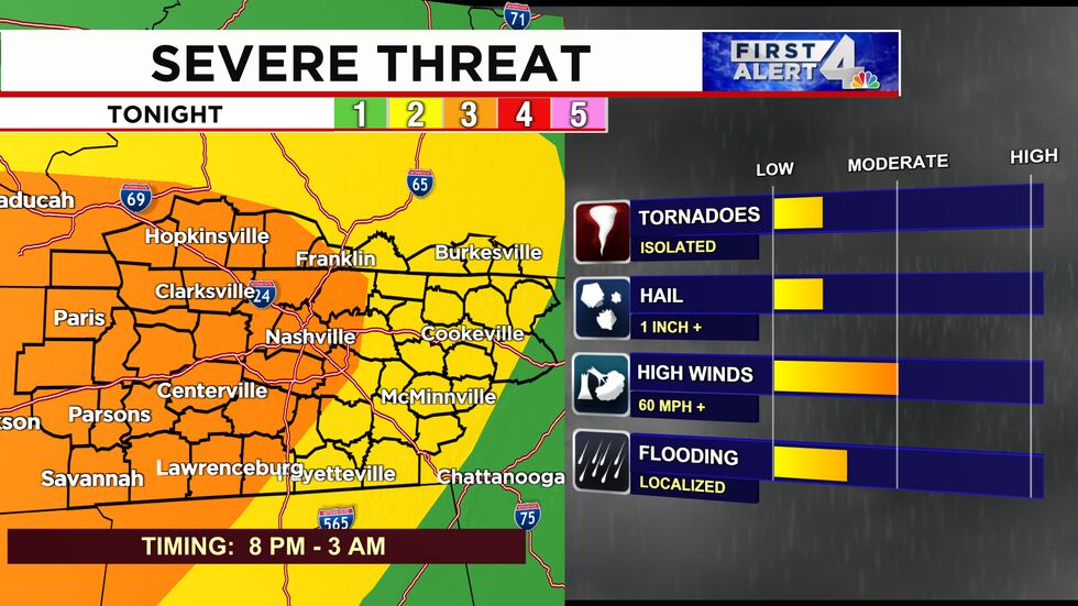
TONIGHT:
A Wind Advisory has been issued for Middle Tennessee until 7 am on Saturday. Wind could gust outside of thunderstorms to 50 mph at times.

A line of strong-severe storms will move into the area from the west this evening around 8 pm. They’ll contain very heavy downpours, frequent lightning, and the threat for damaging wind gusts, isolated tornadoes and localized flooding. A Flood Watch remains in effect for southern Kentucky until 1 pm, Saturday.
Storms should reach Clarksville by 9 pm tonight. Expect them on the west side of Nashville around 10 pm. They’ll move east into Murfreesboro around or just after 11 pm. Storms are expected in Cookeville by 1 am, Saturday. They’ll finally clear the Cumberland Plateau by 3 am.
Most of the rain will clear the area by sunrise on Saturday. However, it’ll stay gusty with southwest winds topping 35 mph at times even after the storms move out.
THIS WEEKEND:
Both Saturday and Sunday will be variably cloudy and very mild. The air will gradually dry out on Saturday. A few showers and isolated storms will be possible from late morning Saturday through early Saturday afternoon east of I-65 as the cold front pushes through.
Sunday will start cooler, in the 40s, but still have highs in the low-mid 70s.
A few showers will be possible especially over southern Middle Tennessee on Sunday night.
NEXT WEEK:
Next week will generally be cooler with low rain chances until Thursday and Friday.

Copyright 2023 WSMV. All rights reserved.