Justin Liles: Round 1 of new storm arrives tonight
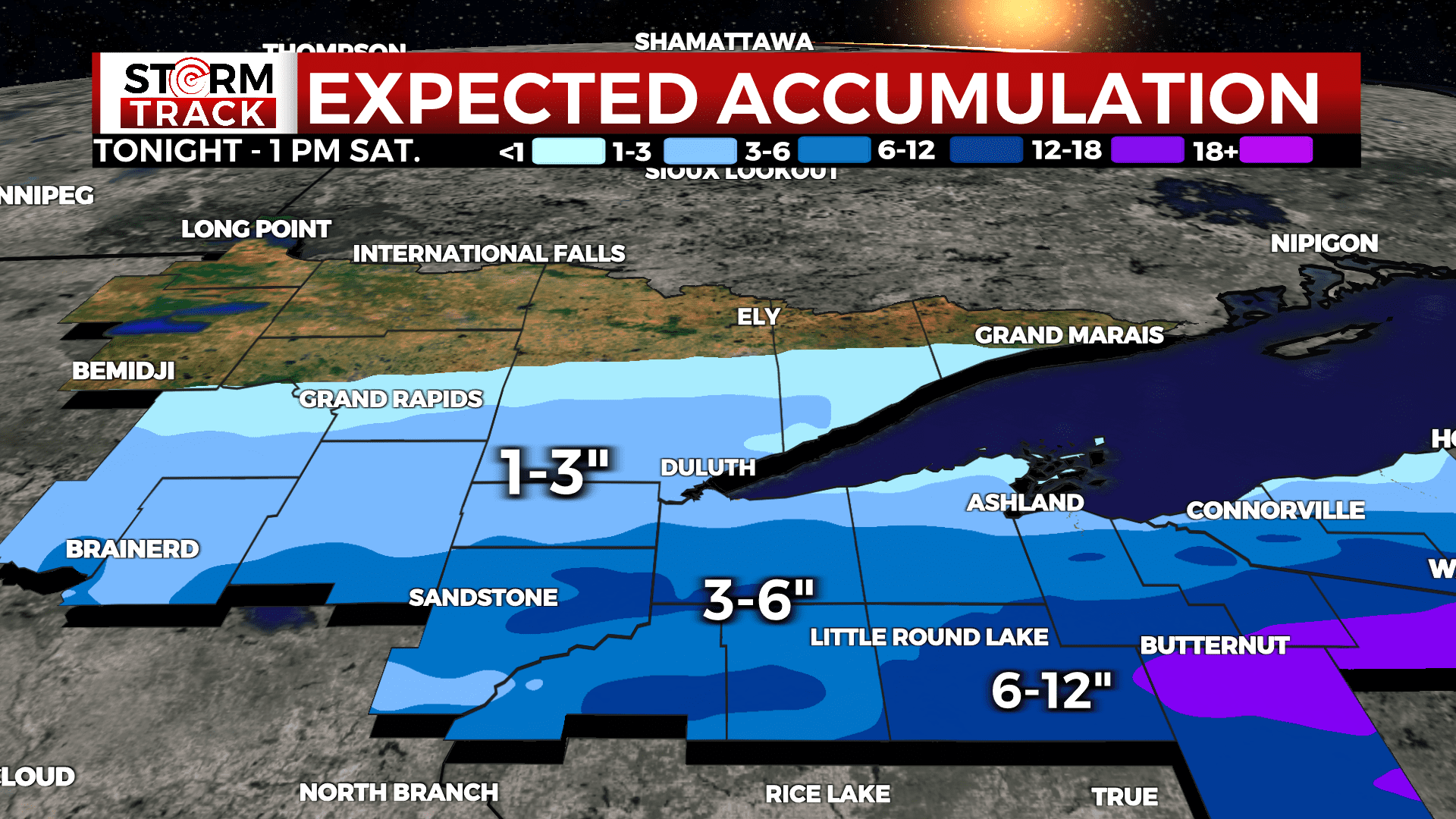
We’re still looking at two wave coming through the Northland this evening. The first wave tonight through tomorrow morning. It still looks as if the system is going to slide farther south. I still think a widespread 1-3” are likely with more to the southeast. The majority of the snow will fall tonight for our area. More snow is likely Friday afternoon into Saturday morning. East central MN and west central WI could see as much as 3-6” of snow. Places located from Hayward, WI east to Butternut could see more than 6” of snow. Plus winds will be high starting Friday afternoon.
Winds will likely gust up over 45-50 mph and winds will be sustained in the mid 20s. Travel will deteriorate the farther you go south Friday. It looks like we’ll get another break Saturday before another light clipper comes through Sunday evening. The start of the workweek looks quiet. However, a rather large Colorado low moves in Tuesday through Thursday next week. There is once again the possibility for significant snow and wind.
TONIGHT
Snow before 4am, then snow likely, possibly mixed with freezing rain. Patchy blowing snow after 4am. Low around 27. Blustery, with a northeast wind 5 to 10 mph increasing to 15 to 20 mph after midnight. Winds could gust as high as 35 mph.
FRIDAY
Snow likely, mainly after 1pm. Patchy blowing snow. Cloudy, with a high near 33. Windy, with a northeast wind 25 to 30 mph, with gusts as high as 50 mph.
FRIDAY NIGHT
A 50 percent chance of snow before 1am. Cloudy, then gradually becoming partly cloudy, with a low around 15. Very windy, with a north wind 25 to 35 mph, with gusts as high as 50 mph.
SATURDAY
Sunny, with a high near 33. Breezy, with a north wind 15 to 20 mph becoming northeast 5 to 10 mph in the afternoon. Winds could gust as high as 30 mph.
SUNDAY
A slight chance of rain and snow before 1pm. Partly sunny, with a high near 45. Breezy, with a south wind 15 to 20 mph, with gusts as high as 25 mph.
MONDAY
Partly sunny, with a high near 41. Breezy, with a west wind 10 to 15 mph, with gusts as high as 20 mph.
TUESDAY
Snow likely. Mostly cloudy, with a high near 33. Windy, with an east wind 15 to 25 mph, with gusts as high as 40 mph..
WEDNESDAY
Snow likely, possibly mixed with rain. Mostly cloudy, with a high near 37. Windy, with an east wind 25 to 30 mph, with gusts as high as 40 mph.