People run from a surge of the 1946 tsunami in Hilo on the Big Island. (Pacific Tsunami Museum/Wikimedia Commons)
Exactly 77 years ago, on April Foolʻs Day 1946, Hilo and the surrounding coast was hit by the most devastating tsunami in Hawaiʻi’s modern history. The death toll was 158.
The tsunami was triggered by a 7.4-magnitude earthquake (although some scientists now say it was closer to 8.5-magnitude) that happened in the middle of the night off the Alaskan coast. Less than five hours later, the monster waves rolled in from the Aleutian Islands, surprising the State of Hawaiʻi.
The first wave entered Hilo Harbor and then receded. The water in the bay seemed to disappear. “Boats were left to the sea floor next to flopping fish,” History.com said.
While some people went to investigate the strange occurrence, the massive tsunami came crashing into the Hilo waterfront, destroying it. The coastal villages were pounded with surges as tall as 3-story buildings. The maximum height was recorded in Ha’ena at 45 feet. A Laupahoehoe schoolhouse was crushed by the tsunami, killing the teacher and 25 students who were inside.
The 1946 tsunami on the Big Island did an estimated $26 million in damage (in 1946 dollars). (Army Corps of Engineers)
The tsunami of April 1, 1946 broke over Pier No. 1 in Hilo Harbor. The man in the foreground (lower left) became one of the 159 deaths on the islands. (Image credit: NOAA)
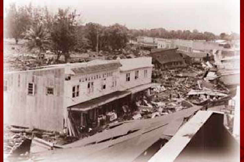
Kuwahara Store was one of the few structures on the ocean side of Kamehameha Avenue in downtown Hilo to survive the 1946 tsunami. (Pacific Tsunami Museum)
The devastation of lives and property ($26 million in damages in 1946 dollars) on that day galvanized an effort to create a tsunami warning system, which it did two years later called the Seismic SeaWave Warning System. It is now known as the Pacific Tsunami Warning Center (headquartered in Ewa Beach on O’ahu), one of two NOAA tsunami warning centers that are staffed 24 hours a day, 7 days a week.
ARTICLE CONTINUES BELOW AD
ARTICLE CONTINUES BELOW AD
“Tsunamis can strike with very little warning and cause enormous destruction,” said James DS. Barros, administrator of the Hawaiʻi Emergency Management Agency in a statement. “We observe Tsunami Awareness Month every year in Hawai‘i, starting on the anniversary of the deadly April Fools’ Day tsunami that caused so much sorrow and damage to our state in 1946.”
There were many lessons learned from that tsunami that are used to help protect people and property today.
The Pacific Tsunami Warning Center directly serves the Hawaiian Islands, the U.S. Pacific and Caribbean territories and the British Virgin Islands and is the primary international forecast center for the Pacific and Caribbean Basins. Tsunamis are Hawaiʻi’s deadliest natural disaster with a total of 293 people having been killed since 1900.
The Hawai‘i Emergency Management Agency defines a tsunami as a series of ocean wave masses generated primarily by earthquakes or underwater volcanic eruptions and landslides. Tsunamis can strike year-round and during any time of the day or night.
“Tsunamis can’t be predicted,” said Dr. Laura Kong, director of the International Tsunami Information Center. “We don’t know when and where the next big one will occur, so we need to be prepared.
ARTICLE CONTINUES BELOW AD
Hawai‘i County is partnering with the nonprofit Vibrant Hawaiʻi in an effort to spread the word on how to be prepared for such a natural disaster.
Talmadge Magno, Hawai‘i County Civil Defense administrator, said they look at all historic events, like the 1946 tsunami, and try to learn from them and incorporate new technology.
Magno said people need to understand the vulnerability along the coastline.
“If they feel an earthquake to the point it scares them, it’s a sign they should move away from the coastline to higher ground,” he said.
Since the coastlines are pretty populated, Magno said, sometimes the best solution is to walk away from the area instead of driving and getting stuck in traffic.
ARTICLE CONTINUES BELOW AD
“Tsunamis often come in multiple waves over a period of hours. Resist the temptation to watch the waves, especially if the water seems to draw back, exposing the ocean floor,” the state emergency management agency said.
On April 22, Magno is doing a preparedness talk at the Pacific Tsunami Museum in Hilo.
The museum, located at 130 Kamehameha Ave., will be offering free admission to first responders (fire, police and rescue personnel) and their families every Saturday this month, starting today. First responders are asked to bring their badge or ID upon entrance.
The biggest goal, Magno said, is to make sure Hawaiʻi County Civil Defense is able to inform as much of the public as possible if such an event occurs.
According to the International Tsunami Information Center, the last tsunami that caused significant damage in Hawai‘i was the 2011 Great East Japan tsunami, which was observed statewide causing $30 million in damage.
In January last year, tsunami surges hit the Kona Coast at 1:30 a.m. on a Saturday following a volcanic eruption that occurred at approximately 6:27 p.m. Hawai‘i Standard Time in the vicinity of Tonga. Flooding was reported at Kailua Pier down to Keauhou Harbor.
As part of the Tsunami Awareness Month observance, the Hawaiʻi Emergency Management Agency will purchase ad time for its “Don’t Fool Around; Get to High Ground!” public service announcement campaign.
The colorful animated PSAs focus on the natural warning signs of a local tsunami – strong shaking, a roaring noise from the ocean, and water receding from the beach – that may indicate that a tsunami is approaching even before the warning sirens sound.
If residents or visitors near shore notice any of those signs, they should immediately move away from the coast; if they can’t retreat to higher terrain, they may also seek shelter in a sturdy building on the fourth floor or higher.
This comments section is a public community forum for the purpose of free expression. Although Big Island Now encourages respectful communication only, some content may be considered offensive. Please view at your own discretion. View Comments