undefined
Posts
undefined
Followers
Coastal Storm Will Start Off Active Week Before Separate Thanksgiving Eve System: Latest
By Joe Lombardi,
22 hours ago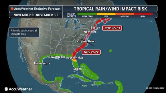
A coastal storm is closing in on the Northeast, with updated forecasts sharpening the timing of its heaviest rain and changing expectations for its strongest winds.
The National Weather Service expects rain to spread across the New York region Sunday afternoon, Nov. 22, and continue into Monday morning, Nov. 23. The heaviest rainfall is expected to be farthest east.
Rain should become widespread Sunday evening, with the overnight hours bringing the greatest concern for downpours across Long Island, Connecticut, and southern New England.
The NWS projects 1 to 2 inches across the New York region, with localized totals approaching 3 inches. Amounts could drop sharply toward New York City and points west if the offshore trend continues.
Farther north, 1 to 3 inches is expected in New England, most likely east of the Connecticut River toward the I-95 corridor. Most heavy rain should exit southern New England by Monday’s morning rush.
AccuWeather also identifies localized flooding potential in Virginia, Maryland, eastern Pennsylvania, and southern New Jersey. Its coastal-risk and impact graphics highlight gusty winds, storm surge, and coastal flooding.
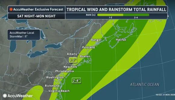
Rainfall through Monday night, Nov. 23, ranges from 1 to 2 inches on the western fringe to 2 to 4 inches in parts of the coastal corridor.
AccuWeatherWind projections require a distinction between coastal communities and waters offshore.
The NWS expects gusts around 25 to 30 mph along the New York-area coast, with a low chance of briefly reaching 40 to 45 mph in a small area farther east. Southern New England’s coastal gusts could reach 25 to 45 mph, strongest near Cape Cod and the islands.
AccuWeather’s updated outlook forecasts a broader coastal zone of 40-to-60-mph gusts but says the likelihood of hurricane-force gusts has decreased. Its supplied map places a stronger 60-to-80-mph band offshore.
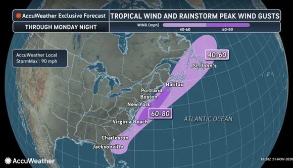
Peak gusts of 40 to 60 mph near the coast are expected, with a stronger offshore band up to 80 mph through Monday night, Nov. 23.
AccuWeatherThe outlet’s track graphic carries the system north toward Atlantic Canada by Monday. Its rainfall map shows 1 to 2 inches along the western fringe and 2 to 4 inches in parts of the coastal corridor.
The NWS expects generally minor coastal impacts from the storm. Brief street flooding remains possible, particularly where drainage is poor. Wet roads and reduced visibility could complicate early holiday trips.
A separate storm could pose a greater coastal flooding threat Thanksgiving Eve on Wednesday night, Nov. 25, into Thanksgiving Day, Thursday, Nov. 26. Its precise track and strength remain uncertain.
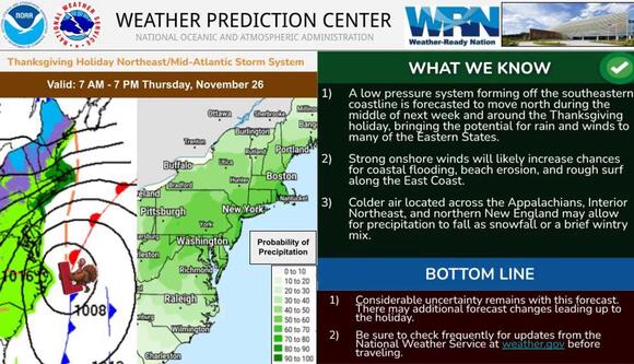
A separate Thanksgiving storm could bring rain, coastal flooding, and an inland wintry mix Thursday, Nov. 26. Forecast uncertainty remains considerable.
National Weather ServiceCheck back with Daily Voice for the latest updates.
 Add to Preferred Sources


